Welcome, Autel Pilots!
Join our free Autel drone community today!
Join Us

RTK EVO TEST 2 with attached data

jmason702

Well-Known Member
Joined
Aug 30, 2020
Messages
1,023
Reaction score
341
Age
46
RTK TEST 2.zip


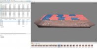
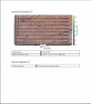
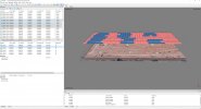
Here is the flight with 6 recorded points ALL in WGS84 Ellipsoid. 80 AGL- 5MPH- 280 photos, I am processing now with DD using points 3 and 6 as checkpoints and the other 4 as GCPs

Feel free to process in Meta and Pix, smooth flight no issues... ALL fixed solutions using NTRIP
 
Google Earth reports the center point of image MAX_0001.jpg as 738.8 meters (2424 feet)
If you add 80 feet to Google Earth's surface level, the camera should actually be close to 763.2 meters (2504 feet)

MAX_0001.jpg exif data reports elevation of the camera as 736.6 meters (2416.7 feet)
An approximate difference of minus 26.6 meters (87.3 feet)

Google Earth is not using ellipsoid height I guess.
 
Last edited:
Am I doing something wrong here? first time using Metashape?
 

Attachments

  • meta.jpg
    meta.jpg
    835.6 KB · Views: 29
Google Earth reports the center point of image MAX_0001.jpg as 738.8 meters (2424 feet)
If you add 80 feet to Google Earth's surface level, the camera should actually be close to 763.2 meters (2504 feet)

MAX_0001.jpg exif data reports elevation of the camera as 736.6 meters (2416.7 feet)
An approximate difference of minus 26.6 meters (87.3 feet)

If you capture an image with the drone on the ground, shouldn't the exif elevation be very close to the ground elevation at that point as referenced to WGS84? Why is it so much lower?
Not sure, unless the drone is trying to project surface elevation?
 
MUCH Better... need to hit the update tab
 

Attachments

  • Meta2.jpg
    Meta2.jpg
    1 MB · Views: 12
I'm guessing that Google Earth uses the EGM96 model for height and that is the difference to the ellipsoid used by the drone. But I was hoping someone would know definitively.
Thats a very good possibility. I have noticed that in my area I am getting between 60 to 80 feet difference when comparing ellipsoid to the geoid
 
  • Like
Reactions: Dave Pitman
DD Report....................... Thoughts??
 

Attachments

  • DD1.jpg
    DD1.jpg
    193.5 KB · Views: 20
  • DD2.jpg
    DD2.jpg
    263.3 KB · Views: 17
  • DD3.jpg
    DD3.jpg
    239.5 KB · Views: 14
  • DD4.jpg
    DD4.jpg
    290.8 KB · Views: 13
  • DD6.jpg
    DD6.jpg
    247.2 KB · Views: 13
  • DD5.jpg
    DD5.jpg
    353.2 KB · Views: 15
It still looks like DD isn't giving a sufficiently heavier weight to the GCPs.

I'm also curious about the GSD calculation of .97 inches/px. That seems like too low of resolution for 80 feet capture height. But I'm referencing a P4P's camera.

What were your overlap settings?
 
Last edited:
  • Like
Reactions: jmason702
The EVOs PRO camera in my opinion is better than P4P, I own both, Then again the P4P has done great also
 
I'm guessing that Google Earth uses the EGM96 model for height and that is the difference to the ellipsoid used by the drone. But I was hoping someone would know d
It still looks like DD isn't giving a sufficiently heavier weight to the GCPs.

I'm also curious about the GSD calculation of .97 inches/px. That seems like too low of resolution for 80 feet capture height. But I'm referencing a P4P's camera.

What were your overlap settings?
I don't know about Drone Deploy, but it does (or did) use Pix4D's Engine, and Pix4D on Mapper Desktop has a default Accuracy setting for GCPs as .02. His images are rated .01.
 
How about you take an image on the ground of the GCP you measured with the Emlids. Nadir, perfectly centered over the target. We then should know what elevation its giving.
 
  • Like
Reactions: jmason702
Pix4D

I took images as WGS84 and elevations as ellipsoid.
I took Control Points as WGS84 and ellipsoid
Out was WGS84 with EGM96 applied.

Orthometric Height is around 737 to 739m

1634431415425.png
1634431468983.png
1634431567736.png

1634431771234.png

Bottom right corner shows the elevation of the selected point on the cloud.
 
  • Like
Reactions: jmason702
I'm also curious about the GSD calculation of .97 inches/px.
The EVOs PRO camera in my opinion is better than P4P, I own both, Then again the P4P has done great also

I'm referring to the Ground Sample Distance, not really the quality of the camera. With a flight height of 80', I would expect a GSD of somewhere around .3 inches/px, not .97 inches/px.

EDIT: I see I was looking at the DEM GSD. Elsewhere in the report, it states .24 inches/px. which makes sense.
 
Last edited:
  • Like
Reactions: jmason702
I don't know about Drone Deploy, but it does (or did) use Pix4D's Engine, and Pix4D on Mapper Desktop has a default Accuracy setting for GCPs as .02. His images are rated .01.
If I'm reading the report correctly, is says that the GCP mean RMS error is .69 inches (.018 m) and the camera position mean RMS error is .42 feet. I think the GCP should be set to at max .005 meters which is what you have in P4D, correct?
 
Last edited:
Pix4D

I took images as WGS84 and elevations as ellipsoid.
I took Control Points as WGS84 and ellipsoid
Out was WGS84 with EGM96 applied.

If I'm reading the report correctly, you used 1 point as a GCP and 5 points as check points. And for the checkpoints, the largest mean RMSE was less than 4cm. Is that correct?
 
  • Like
Reactions: jmason702
If I'm reading the report correctly, is says that the GCP mean RMS error is .69 inches and the camera position mean RMS error is .42 feet. For contrast, I usually set a surveyed GCP to .001 meters (.04 inches) in MS.

Yes

If I'm reading the report correctly, you used 1 point as a GCP and 5 points as check points. And for the checkpoints, the largest mean RMSE was less than 4cm. Is that correct?

Yes.

I left accuracy for the cameras with what's in the metadata. I used .005 for the GCP's.

With my PPK kit i set the cameras to .04 and the Control Points at .2 (Default Pix4D).

I don't know if me only marking 5 images on each point is the problem, as I was in a hurry. I can go back and mark them all if needed.
 
  • Like
Reactions: jmason702

Latest threads

Members online

Forum statistics

Threads
11,291
Messages
103,022
Members
9,902
Latest member
MountainDroneTN