- Joined
- May 9, 2021
- Messages
- 293
- Reaction score
- 153
- Age
- 68
- Location
- Kingwood, TX
- Website
- www.raptoraerialservices.com
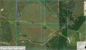
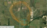
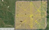
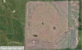
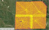
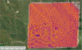
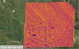
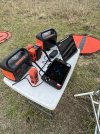
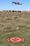
I recently completed a challenging 530 acres RGB Visible and Thermal IR Drone Survey over the southern end of the Hockley Salt Dome. Below are some specs and screen captures of the survey results. My goal is to identify any "thermal" anomalies and ground truth them.
RGB Visible Survey
Thermal IR Survey
RGB Visible Survey
- 4 overlapping sections
- 4 launch points close to the center of each section
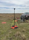
- 5 GCPs
- RTK (EOS Arrow Gold and Emlid Reach RS2+ LOCAL NTRIP)
- Autel Evo II Enterprise Pro 6K V2
- 300 AGL
- 80%/75% Overlap
- 17 MPH
- 2 days
- 6,309 images
Thermal IR Survey
- 4 overlapping sections
- 4 launch points close to the center of each section
- No GCPs
- RTK (EOS Arrow Gold and Emlid Reach RS2+ LOCAL NTRIP)
- Autel Evo II Enterprise V2 RTK with Dual FLIR 640R Radiometric Thermal
- 250 AGL
- 80%/75% Overlap
- 11 MPH
- 4 days (5 days including repeat section)
- 36,689 images (46,285 images including repeat section)
- SimActive Correlator3D (Photogrammetry)
- Global Mapper (GIS)
- Surfer (Final Maps)
Attachments
-
 screen_capture-1.jpg310.9 KB · Views: 39
 -
 screen_capture-2.jpg496.8 KB · Views: 41
 -
 screen_capture-3.jpg309.4 KB · Views: 36
 -
 screen_capture-4.jpg640.8 KB · Views: 39
 -
 screen_capture-5.jpg499.4 KB · Views: 39
 -
 screen_capture-6.jpg510.2 KB · Views: 43
 -
 IMG_5614.JPG2.9 MB · Views: 40
 -
 IMG_5607.JPG3.8 MB · Views: 42
 -
 IMG_7504.JPG3.1 MB · Views: 40
 -
 IMG_5357.JPEG1.6 MB · Views: 41