You are using an out of date browser. It may not display this or other websites correctly.
You should upgrade or use an alternative browser.
You should upgrade or use an alternative browser.
RTK Test with Recorded point with RS2 and Drone on top of point
- Thread starter jmason702
- Start date
Dave Pitman
Well-Known Member
Dave Pitman
Well-Known Member
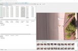
I don't have experience working with an RTK drone in MS, so I'm adapting my GCP workflow. This is what I get using the point as a GCP, and then as a Checkpoint. (Note that my workspace is in FEET, not METERS)
I'm guessing that you did not run OPTIMIZE CAMERAS after you imported the Point and located it in the photos ?
_
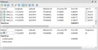
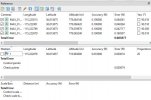
I'm guessing that you did not run OPTIMIZE CAMERAS after you imported the Point and located it in the photos ?
_


Last edited:
WOW, I am new to MS... trying to figure this out. No I did not optimize cameras after importing point and tagging. I did it before then after importing photos... my badI don't have experience working with an RTK drone in MS, so I'm adapting my GCP workflow. This is what I get using the point as a GCP, and then as a Checkpoint. (Note that my workspace is in FEET, not METERS)
I'm guessing that you did not run OPTIMIZE CAMERAS after you imported the Point and located it in the photos ?
_
View attachment 12268
View attachment 12269
Dave Pitman
Well-Known Member
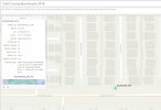
check this out, found a mount point close to my house. I am about to do a small mission over it, I went and painted a circle around it so we can locate it better
Cool. You'll also get to play with entering a known point's coordinates and CRS into your RS2. Hopefully that will go well !
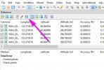
In MS, try this simple workflow.
- Import images
- Align images
- Import Points
- Filter images by point - adjust position in images
- Optimize Cameras
Dave Pitman
Well-Known Member
That could be throwing everything off
Using known points, there is always going to be transformation needed. I don't think they will ever be in WGS84
Last edited:
Dave Pitman
Well-Known Member
another keynote: I have been using my RS2 as a NTRIP caster to the drone. Today I did to missions with the drone connected to the local NTIP by itself. (without the RS2) I seem to get better numbers using the RS2 as a caster.
I think being the Rs2 has a much stronger connection to the NTRIP Mount point. and your way closer to the drone than to the mount point. If that makes sence
I think being the Rs2 has a much stronger connection to the NTRIP Mount point. and your way closer to the drone than to the mount point. If that makes sence
Dave Pitman
Well-Known Member
another keynote: I have been using my RS2 as a NTRIP caster to the drone. Today I did to missions with the drone connected to the local NTIP by itself. (without the RS2) I seem to get better numbers using the RS2 as a caster.
I think being the Rs2 has a much stronger connection to the NTRIP Mount point. and your way closer to the drone than to the mount point. If that makes sence
The base is stationary so it's position should be more accurate when corrected. Then it is providing corrections to the rover (drone). It makes sense.
Maybe compare the accuracy settings in the image EXIF when it is receiving corrections from the base vs. from NTRIP directly, (if you haven't already)
I know how to enter a known point into the RS2 but what is CRS? not familiar with the abbreviation... corrections?Cool. You'll also get to play with entering a known point's coordinates and CRS into your RS2. Hopefully that will go well !
In MS, try this simple workflow.
- Import images
- Align images
- Import Points
- Filter images by point - adjust position in images
- Optimize Cameras
Last edited:
Dave Pitman
Well-Known Member
"Control Reference System" just means the datum used.I know how to enter a known point into the RS2 but what is CRS? not familiar with the abbreviation... corrections?
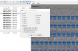
"Adaptive" usually is okay.So when you optimize cameras are you using or checking any of the advanced tabs?
Similar threads
- Replies
- 4
- Views
- 938
- Replies
- 6
- Views
- 2K
- Replies
- 3
- Views
- 611
- Replies
- 28
- Views
- 6K
Latest threads
-
-
-
Seeking Recommendations for Custom Voiceover Solutions
- Started by nobes
- Replies: 1
-
We need your Autel evo 2 V1 6K rugged bundle.
- Started by Autel-euducational
- Replies: 1
-
Questions on original Evo 1 and the new app Autel Sky
- Started by jaja6009
- Replies: 0


