Welcome, Autel Pilots!
Join our free Autel drone community today!
Join Us

RTK Test with Recorded point with RS2 and Drone on top of point

jmason702

Well-Known Member
Joined
Aug 30, 2020
Messages
1,023
Reaction score
341
Age
46

Attachments

  • MAX_0104.JPG
    MAX_0104.JPG
    3.3 MB · Views: 28
  • Drones Point.jpg
    Drones Point.jpg
    108.5 KB · Views: 29
  • RS2 Point.jpg
    RS2 Point.jpg
    28 KB · Views: 28
Last edited:
More
 

Attachments

  • MS no GCP NO CP.jpg
    MS no GCP NO CP.jpg
    176.1 KB · Views: 21
  • Screenshot_20211030-101102_ReachView 3.jpg
    Screenshot_20211030-101102_ReachView 3.jpg
    241.1 KB · Views: 21
  • 20211030_101300.jpg
    20211030_101300.jpg
    890.8 KB · Views: 19
Can not get camera options to stay in manual during missions...?
 
Here is the DD report, no GCPs, and no checks... Since we have already proven the drone to be quite accurate on its own. But this report is by far the best I have ever seen!!! LOL
DD report and Metashape Error side by side.
 

Attachments

  • DDreport.jpg
    DDreport.jpg
    284.8 KB · Views: 24
  • DD report 2.jpg
    DD report 2.jpg
    313.1 KB · Views: 25
  • MS no GCP NO CP.jpg
    MS no GCP NO CP.jpg
    176.1 KB · Views: 26
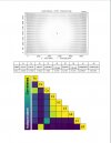
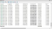
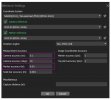
150' AGL, 102 photos, 6 MPH, 80/75 overlap, All fixed solutions Home Test - Google Drive
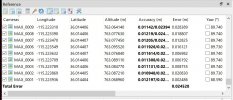
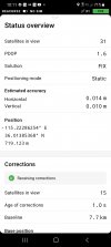
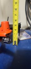
Z vertical, RS2 is saying 716.994, Drone is saying on same point 717.066 meters. That's a 2.834-inch difference, with makes sense cause the drone's antenna sits hight than the point recorded. see attached,
Not sure where the drone's antenna centerline is exactly.
 

Attachments

  • 20211030_121110.jpg
    20211030_121110.jpg
    785.4 KB · Views: 12
Re processed and got the same results... wonder if it is that accurate... I did make a change to the RS2 in base mode before the project
 

Attachments

  • DD Report.jpg
    DD Report.jpg
    281.4 KB · Views: 9
Not sure where the drone's antenna centerline is exactly.

The RS2 (or any survey gnss gear) takes the phase center of the antenna and subtracts the distance of the housing. You input your rover pole height and it subtracts that as well in order to tell you what the coordinate is of the point ON THE GROUND, not the antenna's coordinate.
Similarly, the coordinate written to the image exif should be the camera sensor's position, not the antenna. Without measuring, I'm guessing the center of the evo's sensor is probably closer to 1.5 - 1.75 inches above the ground. If your offsets are correct in the RS2, that is the vertical difference you should get in a perfect world...I think ! If Autel is writing the antenna's coordinate to the image exif, that is an incorrect proceedure. The processing software will not be accounting for the differential between the antenna height and the center of the camera sensor. In fact, with a drone, the height, direction and angle between the antenna and the sensor should all be accounted for when correcting the xyz position from the antenna to the sensor.
 
Last edited:
  • Like
Reactions: jmason702
Yes, my survey point is a 2-meter pole. Then witch should put me at the exact CenterPoint on the ground. I have it set to that perimeter... The drone was set directly over the center of target
 
If you have access to a known point, a reputable monument of some sort, I would set up on that with a FIX solution on the drone directly from the NTRIP network, and see what you get. You should be able to find a list of monuments in your state.
 
Last edited:
  • Like
Reactions: jmason702
Your tests have me close to buying a Evo 2 Enterprise kit along with an RTK module. Keep up the great work!
 
another test at home... This time 200' AGL, 7MPH, 80/70 overlap, no wind, sunny, and still in auto camera with fixed ISO. I can NOT figure out how to map with manual camera settings...

meta shape and DD attached, also the file with one point recorded, if anyone would like to process... only 85 photos


Attachments

  • DD test report.jpg
    DD test report.jpg
    414 KB · Views: 9
  • MS test 2.jpg
    MS test 2.jpg
    238.3 KB · Views: 10
Last edited:
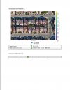
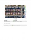
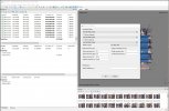
Somehow, I accidentally removed the work area in Meta shape, which also has your photos by point or marker. Not sure how to get it back?

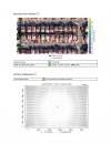
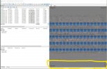
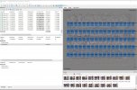
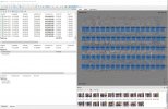
Screenshot attached, also realigned photos
 

Attachments

  • InkedMS_LI.jpg
    InkedMS_LI.jpg
    2.2 MB · Views: 10
With Point and update
 

Attachments

  • msCP.jpg
    msCP.jpg
    915.2 KB · Views: 9
  • msgcp.jpg
    msgcp.jpg
    900.9 KB · Views: 7
using the weighting protocol that I saw on here. let me double-check that
 

Attachments

  • AGI.jpg
    AGI.jpg
    87.1 KB · Views: 13
here is what I used
 

Attachments

  • Screenshot 2021-11-06 180802.jpg
    Screenshot 2021-11-06 180802.jpg
    657.6 KB · Views: 10

Latest threads

Members online

Forum statistics

Threads
11,292
Messages
103,024
Members
9,903
Latest member
Aerugo