Welcome, Autel Pilots!
Join our free Autel drone community today!
Join Us

EVO RTK Map Process with 4 GCPs and 2 CHECKPOINTS

2.5in on checkpoints, we are getting close... :D
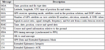
Corrections from base to rover when using Ntrip connection are defined by RTCM protocol:
RTCM Rev3 Common Message Types
Most common message used for >90% of all RTK applications
1004 Extended L1&L2 GPS RTK Observables for GPS RTK Use, the main msg X
1005 Stationary RTK Reference Station ARP X
1006 Stationary RTK Reference Station ARP plus the Antenna Height X
1007 Antenna Descriptor (msg 1008 (X) is also commonly used) X
1012 Extended L1&L2 GLONASS RTK Observables, the other main msg X
1013 System Parameters, time offsets, lists of messages sent
1017 GPS Combined Geometric and Ionospheric Correction Differences
1019 GPS Broadcast Ephemeris (orbits) X
1020 GLONASS Broadcast Ephemeris (orbits) X
1029 Unicode Text String (used for human readable text)
1033 Receiver and Antenna Descriptors
1045 Galileo Broadcast Ephemeris

Most of survey grade recivers work in WGS84 + elipsoid as native (reciver send it to controller), software on controller transforms it to datums set by user. That's defined by NMEA protocol (GLL message).
 

Attachments

  • nmea format.png
    nmea format.png
    37.7 KB · Views: 11
  • Screenshot_20211011-121949~2.png
    Screenshot_20211011-121949~2.png
    155 KB · Views: 11
  • Screenshot_20211011-121803.png
    Screenshot_20211011-121803.png
    109.8 KB · Views: 11
Last edited:
  • Like
Reactions: jmason702
"The position of the camera center relative to the phase center of the airborne A-RTK antenna, under the body axis system: (-2.63, 0.31, 83.5) mm, and the photo EXIF coordinates have been compensated. The positive XYZ axis of the body axis system points to the front, right, and bottom of the aircraft respectively."
I would expect to see this elevation in EXIF.

RTK drone image positions are essentially ACPs (air control points), and the possible error without GCPs is vertical bias, that occurs (logically) due to the way the point cloud point positions are calculated. Using single GCP should be enough to correct it.
Data from P4RTK mostly allows me to get ~ 1 inch accuracy on three axes without using GCPs. (80m AGL, 70/70 overlap nadir only for areas without buildings, checkpoints on the geodetic control line assumed with classic static measurement and precise leveling).

@Blade Strike can you confirm that the antena/camera compesation is implemented?
I'll try to check that but would be great to know from the source :)
Yes it’s accounted for. That was my first question to engineering when I received my unit.. didn’t even want to play with something if it was like a m200 series .
 
  • Like
Reactions: jmason702
"The position of the camera center relative to the phase center of the airborne A-RTK antenna, under the body axis system: (-2.63, 0.31, 83.5) mm, and the photo EXIF coordinates have been compensated. The positive XYZ axis of the body axis system points to the front, right, and bottom of the aircraft respectively."
I would expect to see this elevation in EXIF.

RTK drone image positions are essentially ACPs (air control points), and the possible error without GCPs is vertical bias, that occurs (logically) due to the way the point cloud point positions are calculated. Using single GCP should be enough to correct it.
Data from P4RTK mostly allows me to get ~ 1 inch accuracy on three axes without using GCPs. (80m AGL, 70/70 overlap nadir only for areas without buildings, checkpoints on the geodetic control line assumed with classic static measurement and precise leveling).

@Blade Strike can you confirm that the antena/camera compesation is implemented?
I'll try to check that but would be great to know from the source :)
You are Awesome! Thanks for working on this. I am out of town for work, but I will try this weekend to fly another site and keep all data in WGS84, a smaller site with around 200 photos.
and post up the data. I think its great we can process with 3 different software to compare and test and learn from.
Sounds good. I am glad to just get to see the Evo 2 RTK in action. I may be purchasing.
 
  • Like
Reactions: jmason702
I posted a new flight in a new thread with all data, RTK EVO TEST 2
 
OK , so my remarks as a spatial analyst who has been doing photogrammetry for 30 years. Your error is about 2-3 times your GSD which is not good! Your camera exterior orientation calibration is false - no lens has distortion like this. I have two possible reasons for this both are more than likely contributing. 1) Your GCP layout and number is very poor for the photo count and area; 2) Your various capture methods/settings are not suited to the target object you are trying model.

This includes possibly having too much compression in your photos, you may have been flying too fast, too close to target and getting blur in photos, your camera settings like ISO, focal distance etc were all set to auto and constantly changing, RTK is only at best 1-2 inches accurate so no point in flying for 0.3 inch GSD, and many, many more possible issues.

Photogrammetry is not a push button application and requires a detailed understanding of the science. Simply taking photos and proceeding them in some software all looks good at first glance but if you look a little harder, you get results like what you are seeing.

Reprocessing in different software won’t fix your issues, it will only possibly further hide the issues inherent in the data. Pix 4D is good at this unless you have a cgood understanding of photogrammetry to understand how to read the error reports and the calibration results. No Phantom or EVO will ever produce 'Excelent Results' in my opinion, just 'Pretty Results'. To produce excelent results you need a different type of camera and lens and a lot more.......

Thats my 2 cents worth anyway.
DAMN BRO.... settle down a lil. we just testing this stuff out, I'll be happy to run more testing at different AGL, and the camera settings
 
OK , so my remarks as a spatial analyst who has been doing photogrammetry for 30 years. Your error is about 2-3 times your GSD which is not good! Your camera exterior orientation calibration is false - no lens has distortion like this. I have two possible reasons for this both are more than likely contributing. 1) Your GCP layout and number is very poor for the photo count and area; 2) Your various capture methods/settings are not suited to the target object you are trying model.

This includes possibly having too much compression in your photos, you may have been flying too fast, too close to target and getting blur in photos, your camera settings like ISO, focal distance etc were all set to auto and constantly changing, RTK is only at best 1-2 inches accurate so no point in flying for 0.3 inch GSD, and many, many more possible issues.

Photogrammetry is not a push button application and requires a detailed understanding of the science. Simply taking photos and proceeding them in some software all looks good at first glance but if you look a little harder, you get results like what you are seeing.

Reprocessing in different software won’t fix your issues, it will only possibly further hide the issues inherent in the data. Pix 4D is good at this unless you have a cgood understanding of photogrammetry to understand how to read the error reports and the calibration results. No Phantom or EVO will ever produce 'Excelent Results' in my opinion, just 'Pretty Results'. To produce excelent results you need a different type of camera and lens and a lot more.......

Thats my 2 cents worth anyway.
I like your passion and experience!
 
OK , so my remarks as a spatial analyst who has been doing photogrammetry for 30 years. Your error is about 2-3 times your GSD which is not good! Your camera exterior orientation calibration is false - no lens has distortion like this. I have two possible reasons for this both are more than likely contributing. 1) Your GCP layout and number is very poor for the photo count and area; 2) Your various capture methods/settings are not suited to the target object you are trying model.

This includes possibly having too much compression in your photos, you may have been flying too fast, too close to target and getting blur in photos, your camera settings like ISO, focal distance etc were all set to auto and constantly changing, RTK is only at best 1-2 inches accurate so no point in flying for 0.3 inch GSD, and many, many more possible issues.

Photogrammetry is not a push button application and requires a detailed understanding of the science. Simply taking photos and proceeding them in some software all looks good at first glance but if you look a little harder, you get results like what you are seeing.

Reprocessing in different software won’t fix your issues, it will only possibly further hide the issues inherent in the data. Pix 4D is good at this unless you have a cgood understanding of photogrammetry to understand how to read the error reports and the calibration results. No Phantom or EVO will ever produce 'Excelent Results' in my opinion, just 'Pretty Results'. To produce excelent results you need a different type of camera and lens and a lot more.......

Thats my 2 cents worth anyway.
I am, or we are trying to find the best way to do this... I have processed in many ways, fixed camera settings, etc... Currently trying to do smaller-scale maps to determine accuracy. To see if the EVO RTK is accurate enough.
Testing is the way we will find out, so what is your advice?
 

Latest threads

Members online

Forum statistics

Threads
11,229
Messages
102,656
Members
9,818
Latest member
redwingaerials