Wow man, that’s actually really great modelHow's this for pretty?


You are using an out of date browser. It may not display this or other websites correctly.
You should upgrade or use an alternative browser.
You should upgrade or use an alternative browser.
RTK with Smart Controller is working! And Base Station!
- Thread starter jmason702
- Start date

The one thing about Autel, the IQ. It’s Absolutely stunning.Thank You Sir

Il dato che ti ho riportato con lo stesso rilievo (scatto jpeg + dng contemporaneo) e condizioni uguali (2 gcp e 1qcp) da indicazioni di esattezze diverse è questo grazie al fatto che il dng è un file più ricco e le informazioni migliori sono nelle ombre che nelle alte luci. quindi se vuoi capire capisci altrimenti non c'è peggior sordo di chi non vuol sentire. Avrebbe più senso per il drone memorizzare i dati gnss solo su dng poiché dng è facilmente convertibile in jpeg. Penso di dire cose ovvie che gli ingegneri avranno capito. Ho trovato il modo per archiviare i dati exif (xmp) sul dng, quindi il problema non è più mio. grazie per aver risposto alle domande e alle preoccupazioni. buon lavoroIn realtà è abbastanza buono, ma puoi fare come 3 checkpoint e nessun GCP? Sembra che tu abbia solo un punto di controllo, potrebbe essere sbagliato perché posso leggere tutto.
We tested Autel Enterprise with Explorer 1.0.59 and FW 2.1.57
All fw + app files here: Autel Enterprise + RTK - Google Drive
Tell me the firmware version 2.1.57 on google drive for the drone version without a smart controller?
What nobody knows? Even the owner of google drive?Tell me the firmware version 2.1.57 on google drive for the drone version without a smart controller?
elistechnology
Well-Known Member
Lastest beta version which is:
Autel Explorer 1.1.7.93 https://dl.dropboxusercontent.com/s/wk3fvj4c0fe66id/Explorer_V1.1.7.93-modelc-release.apk?dl=0
EVO II V2: V2.1.61 https://dl.dropboxusercontent.com/s/8cgkywzv1pgzaek/Model-C_WiMax8020_FW_V2.1.61.zip?dl=0
EVO II Downloads
have everything that the version 2.1.57 has + improvement in logging RINEX + RC connection stability + somehow improvemets in RTK connection itself.
Kamil has removed some of the files from his drive, you would need Model-C_WiMax8020_FW_V2.1.57.
Dougcjohn
Well-Known Member
- Joined
- Apr 7, 2019
- Messages
- 187
- Reaction score
- 96
- Age
- 67
That is excellent model and pt Cloud too. The cars wheels, body curves with reflection reproduced very clean. What are you using for your modeling processing?How's this for pretty?
Sorry to ask, but can someone fill me in on the acronyms used in this thread? I am not a technophobe, but I am trying to wrap my head around why this issue is important and what exactly users who are using this are trying to accomplish with their drones.
Any kind of brief explanation and summary would be appreciated. Thanks
Any kind of brief explanation and summary would be appreciated. Thanks
Sorry to ask, but can someone fill me in on the acronyms used in this thread? I am not a technophobe, but I am trying to wrap my head around why this issue is important and what exactly users who are using this are trying to accomplish with their drones.YES, and next is to try it with my base station...
Any kind of brief explanation and summary would be appreciated. Thanks
Drone DeployThat is excellent model and pt Cloud too. The cars wheels, body curves with reflection reproduced very clean. What are you using for your modeling processing?
I will reply to this later, after work. ThanksSorry to ask, but can someone fill me in on the acronyms used in this thread? I am not a technophobe, but I am trying to wrap my head around why this issue is important and what exactly users who are using this are trying to accomplish with their drones.
Any kind of brief explanation and summary would be appreciated. Thanks
edgardcafe
Well-Known Member
I would like to get some info as well ! Thank you !I will reply to this later, after work. Thanks
Malli35998
Well-Known Member
- Joined
- May 9, 2021
- Messages
- 311
- Reaction score
- 153
- Age
- 69
- Location
- Kingwood, TX
- Website
- www.raptoraerialservices.com
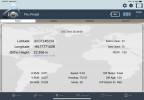
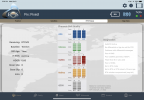
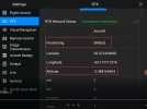
I recently purchased an Evo II Enterprise Pro 6K drone. I received the RTK Module yesterday. I am new using an RTK drone. I have used an EOS Arrow Gold GNSS RTK system for positioning GCPs for several years. Yesterday, I logged into my local NTRIP Network using the Autel Explorer RTK interface on the Smart Controller. After a bit of trial and error, I was able to log in. I was connected to an RTK base station located about 15-16km away using a single mountpoint (RTK_RTCM3). I also setup my EOS Arrow Gold GNSS RTK receiver to record location at same position and altitude as the drone. I let the drone sit for at least 5-10 min to ensure a good fix. In the RTK interface the Positioning showed “SINGLE”. I would have expected “FIX”. The lat-long values looked pretty good. The Altitude shown was way off (even went negative for a short time) vs the EOS Arrow Gold GNSS RTK system. Any thoughts/recommendations would be greatly appreciate.
Attachments
Last edited:
Dear
In the last test carried out with the latest firmware version in evo 2 enterprise RTK the process is working correctly, either in RTK or PPK
For RTK, use i50 GNSS CHCNAV equipment that allows the NTRIP connection configuration, generating a Wi-Fi network with the antenna and connecting the smart controller to said Wi-Fi.
the error on the screen was little more than centimeter flying connected to RTK antenna
for the PPK process, the Rinex and MRK files were satisfactory, providing the necessary information for the post process.
Now we are testing Evo 2 Pro RTK equipment that presents NTRIP connectivity problems (Autel sent us a beta App for android and ISO equipment) and also delivers the incomplete rinex file, for which they told us to install the firmware in its Beta version.
Greetings from Chile!!!!
PS: sorry for my english
My EVO PRO RTK works perfect on NTRIP or from my Base stationDear
In the last test carried out with the latest firmware version in evo 2 enterprise RTK the process is working correctly, either in RTK or PPK
For RTK, use i50 GNSS CHCNAV equipment that allows the NTRIP connection configuration, generating a Wi-Fi network with the antenna and connecting the smart controller to said Wi-Fi.
the error on the screen was little more than centimeter flying connected to RTK antenna
for the PPK process, the Rinex and MRK files were satisfactory, providing the necessary information for the post process.
Now we are testing Evo 2 Pro RTK equipment that presents NTRIP connectivity problems (Autel sent us a beta App for android and ISO equipment) and also delivers the incomplete rinex file, for which they told us to install the firmware in its Beta version.
Greetings from Chile!!!!
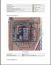
PS: sorry for my englishView attachment 11823View attachment 11824View attachment 11825View attachment 11826View attachment 11827
Similar threads
- Replies
- 4
- Views
- 949
- Replies
- 0
- Views
- 673
- Replies
- 3
- Views
- 2K
- Replies
- 1
- Views
- 1K
- Replies
- 13
- Views
- 5K


Latest threads
-
-
Onocoy NTRIP. Has anyone tried this set up for RTK drone survey (photo mosaic and 3D capture and generation).
- Started by HorusQcopter
- Replies: 0
-
-
-