EVO RTK


You are using an out of date browser. It may not display this or other websites correctly.
You should upgrade or use an alternative browser.
You should upgrade or use an alternative browser.
Comparing Evo II Enterprise to Mavic 3 Enterprise for Mapping
- Thread starter yarrr
- Start date


jmason,
Thanks for the images from the Mavic 3E!!!
I have been playing with them and wow I got some great results.
I am processing another round from them so I cannot look but, were your images nadir only?
With no GCPs and 4 CPs I am getting really tight data.
My Phantom 4 RTK will have a vertical shift if I don't have the Altitude Optimization (1 Line of oblique) on.

I had a lower RMSE but have been playing around with Gradual Selection.
I also had Agisoft import the camera calibration from the metadata, I may try to run it again and just let Agisoft figure out the calibration to see if there is a large difference.
At work we really want to buy a dedicated mapping drone to monitor our beaches and the Mavic 3E looks really good! But the Sensefle eBee and its over people qualification will probably be a better fit since its a fix wing and can fly over people.
I'll report back after I play around with some settings.
Thanks for the images from the Mavic 3E!!!
I have been playing with them and wow I got some great results.
I am processing another round from them so I cannot look but, were your images nadir only?
With no GCPs and 4 CPs I am getting really tight data.
My Phantom 4 RTK will have a vertical shift if I don't have the Altitude Optimization (1 Line of oblique) on.
I had a lower RMSE but have been playing around with Gradual Selection.
I also had Agisoft import the camera calibration from the metadata, I may try to run it again and just let Agisoft figure out the calibration to see if there is a large difference.
At work we really want to buy a dedicated mapping drone to monitor our beaches and the Mavic 3E looks really good! But the Sensefle eBee and its over people qualification will probably be a better fit since its a fix wing and can fly over people.
I'll report back after I play around with some settings.

Yeah I finally saw that there was the altitude optimization there.yes all images are nadir with the exception of Altitude Optimization on the last pass
Thanks again. I am going to run the Evo 2 data next.
This gives me good data to give to other public safety agencies when they want to see the different outputs from Evo 2 RTK, Mavic 3E which I don't have access to at this time.
Anyone know where I can get Matrice 300 RTK images taken with a P1 or L1? I want to compare the outputs to a Sony A7.
The Evo map has some problems that are not present in the same areas of the M3E map.In my shared DD maps, witch ortho looks better to you. The M3E OR EVO?
I noticed issues like this freqently when processing Evo images with WebODM.
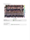
Attachments
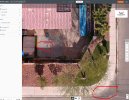
In my shared DD maps, witch ortho looks better to you. The M3E OR EVO?
I think I like the coloring and exposure of the Evo map, but as yarr stated the Evo map has a lot more stitching errors.
I wouldn't be mad with either one of them for my use cases.
But neither is enough to make me move past my Phantom 4 RTK as it does what I need easily and I have 10 batteries for it.
The rate of technological advancement may have the Mavic 4 E having a Full Frame sensor. That will be my next mapping upgrade personally. For work though, the eBee with it flight over people is what I really need to be able to fully map our beaches in one day.
Thanks to both yarr and jmason for such a great thread.
Also is your dog allowed in the pool? In my Agimap he looks tempted.
Yes, he is allowed, but to cold right now, but he will still jump in sometimesAlso is your dog allowed in the pool? In my Agimap he looks tempted.
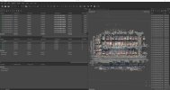
I ran the data some more times in Agisoft.
I had a vertical shift for the Evo 2 data like it is missing the oblique images, which it is not.
Also, can anyone confirm this, does the Evo 2 give camera calibration parameters in its metadata? Upon uploaidng the images when you look at Camera Calibration it is populated just like the Mavic 3E and Phantom 4 RTK.
With the Evo 2 and using the Precalibrated Camera Calibration imported but not fixed I had a vertical shift of 10 cm, but X and Y were tight.
Next I let Agisoft do the Camera Calibration with Auto and the results tightened right up.
With the Phantom 4 RTK, I sometimes try using the Precalibrated Camera params as a starting point and then let Agisoft change them, but not all the time.

Thanks to all for the testing and images. This should help others when making a choice.
For me I will not upgrade my mapping solution until there is a Mavic or Evo with a Full Frame camera.
I am still very happy with my Phantom 4 RTK results in both precision and accuracy as well as the density and color of the point cloud and the other outputs.
I had a vertical shift for the Evo 2 data like it is missing the oblique images, which it is not.
Also, can anyone confirm this, does the Evo 2 give camera calibration parameters in its metadata? Upon uploaidng the images when you look at Camera Calibration it is populated just like the Mavic 3E and Phantom 4 RTK.
With the Evo 2 and using the Precalibrated Camera Calibration imported but not fixed I had a vertical shift of 10 cm, but X and Y were tight.
Next I let Agisoft do the Camera Calibration with Auto and the results tightened right up.
With the Phantom 4 RTK, I sometimes try using the Precalibrated Camera params as a starting point and then let Agisoft change them, but not all the time.
Thanks to all for the testing and images. This should help others when making a choice.
For me I will not upgrade my mapping solution until there is a Mavic or Evo with a Full Frame camera.
I am still very happy with my Phantom 4 RTK results in both precision and accuracy as well as the density and color of the point cloud and the other outputs.


My WEB ODM keeps crashing after the latest update... any advise?I noticed issues like this freqently when processing Evo images with WebODM.
I ran it again with camera opt. in auto and still was off 5cm on the Z. With the EVO
If you have time and you explain your workflow in Metashape. I understand if you don't have time for such a task.
I'll keep working on it.
Thanks
If you have time and you explain your workflow in Metashape. I understand if you don't have time for such a task.
I'll keep working on it.
Thanks
Similar threads
- Replies
- 0
- Views
- 663
- Replies
- 8
- Views
- 895
- Replies
- 5
- Views
- 783
- Replies
- 4
- Views
- 936


Latest threads
-
-
-
Seeking Recommendations for Custom Voiceover Solutions
- Started by nobes
- Replies: 1
-
We need your Autel evo 2 V1 6K rugged bundle.
- Started by Autel-euducational
- Replies: 1
-
Questions on original Evo 1 and the new app Autel Sky
- Started by jaja6009
- Replies: 0