Welcome, Autel Pilots!
Join our free Autel drone community today!
Join Us

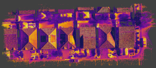
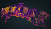
EVO2 Enterprise DUAL 640T RTK: maps and models of IR and RGB jpegs (NTRIP data)

my thoughts are leaning in the same direction, I don't understand why FLIR RJPEG won't work with their software... But FLIR is very popular. with that said I don't think you can go wrong with the 640R and it meets the USA standards also! I wish someone on here owned a 640R or could give us all the details like mapping with it extra, FLIR is a trusted name and has great software to use, and everyone likes it. I do not know if FLIR studio can work with orthos?? and yes this kinda is starting to make me mad. we can only use the IRPCTool.

What software is that company using??
 
Last edited:
my thoughts are leaning in the same direction, I don't understand why FLIR RJPEG won't work with their software... But FLIR is very popular. with that said I don't think you can go wrong with the 640R and it meets the USA standards also! I wish someone on here owned a 640R or could give us all the details like mapping with it extra, FLIR is a trusted name and has great software to use, and everyone likes it. I do not know if FLIR studio can work with orthos?? and yes this kinda is starting to make me mad. we can only use the IRPCTool
So is the problem with the 640T is that it does not use RJPEG??? Can people chime in on this that own a 640T?
 
  • Like
Reactions: ChristianH
you said you had 2 requests, did the other accept the 640T. I think the company you were talking to is DJI fanboys. and use their software, to be honest after some thought.
For the most part, I think some people want FLIR and some don't care either way.
Attached is something else I saw... Let me know your thoughts
 

Attachments

  • sky link.jpg
    sky link.jpg
    209.2 KB · Views: 19
anyone knows the GSD of the Evo 2 640T Enterprise without the RTK module? thanks...
The GSD is the distance between center points of each sample on the ground, which in this case are represented by pixels of images representing the ground. This is going to be a function of sensor size, picture MP and distance / height flown. The sensor on the 640T is smaller then the 6K Pro camera for example, so keep that in mind. Secondly, this has nothing to do with how accurate and precise the "mapping" is to the actual geo location. Using surveyed GCP's will help anchor the mapping to a better accuracy and precision. Adding RTK or PPK post processing should give between 1-3 cm of accuracy and precision if GSD is around 1cm. Remember, if not a licensed "surveyor" do not claim a survey.
 
  • Like
Reactions: ChristianH
Could someone please send me a sample thermal dataset of a 640T and/or 640R ?
I'd like to test them on my local WebODM instance.
 
Pix-Pro is done, WebODM still processing.
*edit: for Pix-Pro I can only process 300 Images at once because of my licence model. So I've processed the first 300.
*edit2: Pix-Pro officially don't supports thermal imaging pictures
1653931864380.png

*edit3: WebODM is done but it's a fail. While it was processing, I read that it's not supporting thermal imaging as of now:
1653939561354.png
*edit4: attaching the report, it doesn't seem to bad. Only the point cloud is messed up.

May I use this dataset for further testing with the WebODM and Pix-Pro team, do you allow it @jmason702 ?
 

Attachments

  • Summary_640T_Test.pdf
    108.8 KB · Views: 6
  • Pillar-Rock-Court-3052022-report_reprint.pdf
    4.5 MB · Views: 1
Last edited:
  • Like
Reactions: jmason702
anyone knows the GSD of the Evo 2 640T Enterprise without the RTK module? thanks...
The imagery’s ground resolution for RGB-only nadir missions at 60 m AGL is 1 cm/px (7680x4320px).
For missions with dual imagery (RGB+IR) the GSD at 60 m AGL for RGB is 2 cm/px (3840x2160px, FOV 79°) and 5.5 cm/px for IR (640x512px, FOV 33°).
 

Latest threads

Members online

No members online now.

Forum statistics

Threads
11,226
Messages
102,644
Members
9,818
Latest member
redwingaerials