

You are using an out of date browser. It may not display this or other websites correctly.
You should upgrade or use an alternative browser.
You should upgrade or use an alternative browser.
EVO2 Enterprise DUAL 640T RTK: maps and models of IR and RGB jpegs (NTRIP data)
- Thread starter vr-pilot
- Start date

ChristianH
Active Member
I might be able to try this with Agisoft Metashape. I'm curious to see first-hand how it handles the thermal data.Here is the data set on the thermal map, if anyone once to try it on MS or PIX, when I tried it on MS it did not go well... not sure if you have to set it up for thermal or how to
125 AGL 85/80 overlap, 5MPH iron bowThermal Map - Google Drive color
Last edited:
378 photosI might be able to try this with Agisoft Metashape. I'm curious to see first-hand how it handles the thermal data.
ChristianH
Active Member
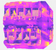
I was able to make a thermal orthomosaic from the TIFF files, see attached. One issue I've run into is the scaling of the temperature values which requires a conversion equation (current values are in the ~3000 range). I've found references to other thermal sensors for this conversion factor but not for the Autel 640T (XT709). reference link here378 photos
The ortho from the JPEG image is just an RGB image without temperature values which is why your "thermal" ortho doesn't have temperatures. I've attached the simple JPEG ortho I created in metashape.
Cheers,
Christian
Attachments

Thanks for your work, Looks great, I would like to know how to reference the data from the 640T... something to look into.
Thanks
Thanks
- Joined
- Nov 11, 2021
- Messages
- 76
- Reaction score
- 50
- Age
- 56
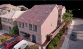
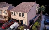
The 48 MP 3D model looks very detailed!640T 8000x6000 Model of my home
What is your impression in terms of "denser point cloud"? Does "higher pixel count" lead to a more true representation of i.e. "roof edges" in comparison to the 20MP camera?
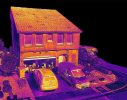
That thermal ortho looks also fantastic! Very much detail in the temperature spreads! It can very well be utilized for many kinds of analyzes...Thermal Ortho with DD, I can not do temp points or read the radiometric values on DD because I don't have the enterprise plan
Wow! Did you thought it would come out this well? Imagine all the kinds of 3D representations were relative temperature depiction is already a good enough approach.Thermal Model... I thought thermal models were very hard to pull off?
DD is doing a great job in putting all this imagery together...
- Joined
- Nov 11, 2021
- Messages
- 76
- Reaction score
- 50
- Age
- 56
Thank you for investigating an "absolute temperature" measurement approach. The MS workflow utilizing the "Raster Calculator" is great! Also the applied color palette is convincing.The ortho from the JPEG image is just an RGB image without temperature values which is why your "thermal" ortho doesn't have temperatures. I've attached the simple JPEG ortho I created in metashape.
From my experience DD is the unbeaten champion when it comes to map and model "finalization" in terms of getting even the most difficult processing job done. It is a black box though and quite pricy if you want all options available.
MS lets (or forces) you dive deeply into the matter but requires fixing some problems yourself, which at the end of the day leads to a better overall understanding of the photogrammetry job itself. (But the MS way is harder than throwing images into DD's cloud.)
P4D left me disappointed to some degree in the past, but there seem to be enough satisfied users.
Last edited:
ChristianH
Active Member
I've used P4D for processing regular RGB data but it struggled with thermal imagery. Agisoft Metashape seems to do a good job at multiple tasks and input data types. I've tried MS once before when looking for a simple ortho solution, I'll have to try messing with it a bit more.Thank you for investigating an "absolute temperature" measurement approach. The MS workflow utilizing the "Raster Calculator" is great! Also the applied color palette is convincing.
From my experience DD is the unbeaten champion when it comes to map and model "finalization" in terms of getting even the most difficult processing job done. It is a black box though and quite pricy if you want all options available.
MS lets (or forces) you dive deeply into the matter but requires fixing some problems yourself, which at the end of the day leads to a better overall understanding of the photogrammetry job itself. (But the MS way is harder than throwing images into DD's cloud.)
P4D left me disappointed to some degree in the past, but there seem to be enough satisfied users.
I checked out the Autel IR_PCTool utility and it works so long as you have the JPEG and IRG files. The thermal data is stored in the IRG file as well as the TIFF file. I was hoping to get clues as to what the conversion formula is for the XT709 TIFF files by comparing spot values in IR_PCTool to the output thermal ortho from TIFF files in Metashape. It appears that the scaling factor is around *0.01 but that's about all I can really say unless there are some ground control points for temperature.
From the video links you shared, the gentlemen processing the survey data with Metashape were showing that RTK was working however, the orthomosaic produced did not have thermal data embedded. I know this because Metashape can only use TIFF's for thermal maps (manual here) and the orthos they made were directly from the JPEG files (they point this out in the video). I'd be curious to see them follow up with a thermal ortho and to know what conversion formula they use to get absolute temperature values. This would be key in thermal mapping.
Cheers,
Christian
So being that the IR_PCTool uses IRG and TIFF files to obtain temperature data, are we getting absolute temps?? Or relative temps??I've used P4D for processing regular RGB data but it struggled with thermal imagery. Agisoft Metashape seems to do a good job at multiple tasks and input data types. I've tried MS once before when looking for a simple ortho solution, I'll have to try messing with it a bit more.
I checked out the Autel IR_PCTool utility and it works so long as you have the JPEG and IRG files. The thermal data is stored in the IRG file as well as the TIFF file. I was hoping to get clues as to what the conversion formula is for the XT709 TIFF files by comparing spot values in IR_PCTool to the output thermal ortho from TIFF files in Metashape. It appears that the scaling factor is around *0.01 but that's about all I can really say unless there are some ground control points for temperature.
From the video links you shared, the gentlemen processing the survey data with Metashape were showing that RTK was working however, the orthomosaic produced did not have thermal data embedded. I know this because Metashape can only use TIFF's for thermal maps (manual here) and the orthos they made were directly from the JPEG files (they point this out in the video). I'd be curious to see them follow up with a thermal ortho and to know what conversion formula they use to get absolute temperature values. This would be key in thermal mapping.
Cheers,
Christian
-Let me pull up the point cloud and I will screenshot itThe 48 MP 3D model looks very detailed!
What is your impression in terms of "denser point cloud"? Does "higher pixel count" lead to a more true representation of i.e. "roof edges" in comparison to the 20MP camera?
That thermal ortho looks also fantastic! Very much detail in the temperature spreads! It can very well be utilized for many kinds of analyzes...
Wow! Did you thought it would come out this well? Imagine all the kinds of 3D representations were relative temperature depiction is already a good enough approach.
DD is doing a great job in putting all this imagery together...
-No I did not expect the thermal ortho to turn out as well as it did! DD is great at stitching. I love DD, just not their pricing structure! Wish I could get a discount
Do you have DD enterprize? Can you process some of this imagery if you do? I would love to see the thermal capabilities of DDThank you for investigating an "absolute temperature" measurement approach. The MS workflow utilizing the "Raster Calculator" is great! Also the applied color palette is convincing.
From my experience DD is the unbeaten champion when it comes to map and model "finalization" in terms of getting even the most difficult processing job done. It is a black box though and quite pricy if you want all options available.
MS lets (or forces) you dive deeply into the matter but requires fixing some problems yourself, which at the end of the day leads to a better overall understanding of the photogrammetry job itself. (But the MS way is harder than throwing images into DD's cloud.)
P4D left me disappointed to some degree in the past, but there seem to be enough satisfied users.
I have access to it. I will run it now and post results.Do you have DD enterprize? Can you process some of this imagery if you do? I would love to see the thermal capabilities of DD
I tried to upload the images and the metadata files. It would not accept the metadata files. Any ideas?
Last edited:
Prolly because its Autel, and they don't support the platformI have access to it. I will run it now and post results.
I tried to upload the images and the metadata files. It would not accept the metadata files. Any ideas?
Prolly because its Autel, and they don't support the platform
Drone Deploy Thermal Map
DroneDeploy
 www.dronedeploy.com
When I uploaded thermal images from my Mavic 2 Enterprise Advanced the map stitched. The stitching was not good, but it did have radiometric data. The radiometric data was inaccurate.
With the Autel Evo 2 640 images the map stitched to together very nicely, but no radiometric data.
I am sure both platforms will be fixed in the future, Drone Deploy is forever on the move.
Mavic 2 Enterprise Advanced Thermal Map - Radiometric
DroneDeploy
 www.dronedeploy.com
Last edited:
ChristianH
Active Member
In my case, Agisoft Metashape doesn't suppor R-JPEG but it does support TIFF. I wonder if DD can even make use of the IRG or TIFF files?Drone Deploy Thermal Map
DroneDeploy
When I uploaded thermal images from my Mavic 2 Enterprise Advanced the map stitched. The stitching was not good, but it did have radiometric data. The radiometric data was inaccurate.
With the Autel Evo 2 640 images the map stitched to together very nicely, but no radiometric data.
I am sure both platforms will be fixed in the future, Drone Deploy is forever on the move.
Mavic 2 Enterprise Advanced Thermal Map - Radiometric
DroneDeploy
edit: just found this on DD FAQ:
Can you process thermal imagery in DroneDeploy?
Currently, we are able to stitch thermal orthomosaics via Thermal Live Map. We are working to support radiometric JPG and TIFF files."Seems like a bit of a tail chasing, but if you've tried it on your DD then I'd probably trust that information. Sidenote: Thermal GCPs would be very beneficial if DD incorporated them.
Note: The IR_PCTool only uses JPEG and IRG. It appears that it uses the JPEG for the display (RGB) on screen and then it uses the IRG thermal data as an overlay so you can query temperatures. It doesn't use the TIFF file because I've tested different combinations of file types in a single folder with the tool.So being that the IR_PCTool uses IRG and TIFF files to obtain temperature data, are we getting absolute temps?? Or relative temps??
When an ortho is made from the JPEG alone in DD, P4D, Metashape, etc., it is only an RGB image. You need the IRG, a converted R-JPEG or TIFF to create an ortho with temperature data. The IRG and TIFF files contain absolute temperature (radiometric) though the numbers stored in those files aren't necessarily degrees C as I've found out with the TIFF ortho (it needs a conversion formula). Hope that makes sense.
-Christian
ChristianH
Active Member
I posted PNG screenshots, you could post a secure folder link if you wanted to share the actual files.I have access to it. I will run it now and post results.
I tried to upload the images and the metadata files. It would not accept the metadata files. Any ideas?
Similar threads
- Replies
- 0
- Views
- 641
- Replies
- 6
- Views
- 2K
- Replies
- 4
- Views
- 2K
- Replies
- 9
- Views
- 3K
- Replies
- 4
- Views
- 3K

