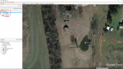
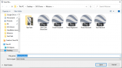
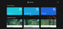
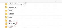
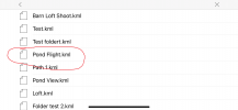
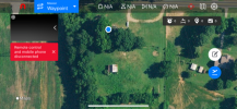
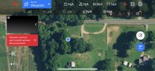
Saw your note about the kml import using steps I mentioned other day not working with a GE kml you created. Went into GEP (should work with GE as well), created a folder with four waypoints, WPT1, WPT2, WPT3, WPT4. For each, assigned an altitude relative to ground (default is something else) in meters. Then saved the folder as a kml (note default is kmz). Copied the kml to app/device per my notes from other day and put in the autel explorer folder. Opened missions, imported kml, all was good, all four waypoint and their alt, saved it as a different name, etc.
The following is what the kml looks like:
<?xml version="1.0" encoding="UTF-8"?>
<kml xmlns="
http://www.opengis.net/kml/2.2" xmlns:gx="
http://www.google.com/kml/ext/2.2" xmlns:kml="
http://www.opengis.net/kml/2.2" xmlns:atom="
Atom Syndication Format namespace">
<Document>
<name>DowntownStillwater.kml</name>
<StyleMap id="m_ylw-pushpin">
<Pair>
<key>normal</key>
<styleUrl>#s_ylw-pushpin</styleUrl>
</Pair>
<Pair>
<key>highlight</key>
<styleUrl>#s_ylw-pushpin_hl</styleUrl>
</Pair>
</StyleMap>
<Style id="s_ylw-pushpin">
<IconStyle>
<scale>1.1</scale>
<Icon>
<href>
http://maps.google.com/mapfiles/kml/pushpin/ylw-pushpin.png</href>
</Icon>
<hotSpot x="20" y="2" xunits="pixels" yunits="pixels"/>
</IconStyle>
</Style>
<Style id="s_ylw-pushpin_hl">
<IconStyle>
<scale>1.3</scale>
<Icon>
<href>
http://maps.google.com/mapfiles/kml/pushpin/ylw-pushpin.png</href>
</Icon>
<hotSpot x="20" y="2" xunits="pixels" yunits="pixels"/>
</IconStyle>
</Style>
<Style id="s_ylw-pushpin_hl0">
<IconStyle>
<scale>1.3</scale>
<Icon>
<href>
http://maps.google.com/mapfiles/kml/pushpin/ylw-pushpin.png</href>
</Icon>
<hotSpot x="20" y="2" xunits="pixels" yunits="pixels"/>
</IconStyle>
</Style>
<StyleMap id="m_ylw-pushpin0">
<Pair>
<key>normal</key>
<styleUrl>#s_ylw-pushpin0</styleUrl>
</Pair>
<Pair>
<key>highlight</key>
<styleUrl>#s_ylw-pushpin_hl0</styleUrl>
</Pair>
</StyleMap>
<Style id="s_ylw-pushpin0">
<IconStyle>
<scale>1.1</scale>
<Icon>
<href>
http://maps.google.com/mapfiles/kml/pushpin/ylw-pushpin.png</href>
</Icon>
<hotSpot x="20" y="2" xunits="pixels" yunits="pixels"/>
</IconStyle>
</Style>
<Folder>
<name>DowntownStillwater</name>
<open>1</open>
<Placemark>
<name>WPT4</name>
<open>1</open>
<LookAt>
<longitude>-92.80122997210027</longitude>
<latitude>45.05551847171713</latitude>
<altitude>0</altitude>
<heading>1.582849244737425</heading>
<tilt>42.79317963865753</tilt>
<range>447.6557441501732</range>
<gx:altitudeMode>relativeToSeaFloor</gx:altitudeMode>
</LookAt>
<styleUrl>#m_ylw-pushpin</styleUrl>
<Point>
<altitudeMode>relativeToGround</altitudeMode>
<gx:drawOrder>1</gx:drawOrder>
<coordinates>-92.80341385667415,45.05549823202078,50.00000000000001</coordinates>
</Point>
</Placemark>
<Placemark>
<name>WPT3</name>
<open>1</open>
<LookAt>
<longitude>-92.80156942084959</longitude>
<latitude>45.0572025499004</latitude>
<altitude>0</altitude>
<heading>1.582609018330471</heading>
<tilt>42.7931787432212</tilt>
<range>447.5090078370976</range>
<gx:altitudeMode>relativeToSeaFloor</gx:altitudeMode>
</LookAt>
<styleUrl>#m_ylw-pushpin</styleUrl>
<Point>
<altitudeMode>relativeToGround</altitudeMode>
<gx:drawOrder>1</gx:drawOrder>
<coordinates>-92.79970861411709,45.05713786669462,70</coordinates>
</Point>
</Placemark>
<Placemark>
<name>WPT1</name>
<LookAt>
<longitude>-92.80372842165717</longitude>
<latitude>45.05861813038249</latitude>
<altitude>0</altitude>
<heading>1.581111387851459</heading>
<tilt>42.83385512269637</tilt>
<range>430.483021297643</range>
<gx:altitudeMode>relativeToSeaFloor</gx:altitudeMode>
</LookAt>
<styleUrl>#m_ylw-pushpin0</styleUrl>
<Point>
<altitudeMode>relativeToGround</altitudeMode>
<gx:drawOrder>1</gx:drawOrder>
<coordinates>-92.80458492905071,45.05880671281025,39.99999999999999</coordinates>
</Point>
</Placemark>
<Placemark>
<name>WPT2</name>
<LookAt>
<longitude>-92.80353065241725</longitude>
<latitude>45.05759828154165</latitude>
<altitude>0</altitude>
<heading>1.5816972076382</heading>
<tilt>51.48706590935318</tilt>
<range>310.0276532931038</range>
<gx:altitudeMode>relativeToSeaFloor</gx:altitudeMode>
</LookAt>
<styleUrl>#m_ylw-pushpin0</styleUrl>
<Point>
<altitudeMode>relativeToGround</altitudeMode>
<gx:drawOrder>1</gx:drawOrder>
<coordinates>-92.8045410805169,45.05727630966438,39.99999999999999</coordinates>
</Point>
</Placemark>
</Folder>
</Document>
</kml


")

