Sounds like you are trying to stich a map/model mission? If so, then there are DroneDeploy, Pix4D among others. If you are a DiY and computer/software tech savy, there is opensource webodm/odm that you can deploy on your own computer, or via Azure or other clouds.
Note some software/platforms may have a limit on number of images per map/model also dependent on plan/subscription or free/trial version. Have used Pix4D, routinely used DD, as well as webodm/odm.
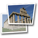
Here's example of a 231 image via Autel mission (3D/crisscross) processed via webodm (free)

If you have not done so, you sign up for a trial of software/platforms such as DD, pix4d, etc and upload a subset of your missions to see how it works.
Otoh, if you are stiching panos, 180, 360, sphereical, etc, 1000+ images is a lot, however there are numerous tools from Adobe PS among others, and a free tool from Microsoft called ICE (Image Composite Editor) that is a great resource.