Welcome, Autel Pilots!
Join our free Autel drone community today!
Join Us

stitching a large number of mission photo's

bruik

Member
Joined
Mar 6, 2021
Messages
16
Reaction score
3
Age
57
Dear forum members.
The other day I let my EVO II pro fly a mission. It took 1110 high quality photos of a certain building site.
The overlap is about 80%.
Now I would like to stitch these photo's together into one big high quality photo.
Any suggestions on how to do that?
Thanks for your time.
 
Dear forum members.
The other day I let my EVO II pro fly a mission. It took 1110 high quality photos of a certain building site.
The overlap is about 80%.
Now I would like to stitch these photo's together into one big high quality photo.
Any suggestions on how to do that?
Thanks for your time.

PTGUI....for the best results you will want the Pro version, but for your project the regular version should suffice.

 
a MapsMadeEasy account will do it for you, charging per job, and produce a DEM and a point cloud as well as a .jpg and .tif (?) of the stitched images. Am interested to know whether PTGUI can incorporate the real world coordinates and position the image correctly.
 
a MapsMadeEasy account will do it for you, charging per job, and produce a DEM and a point cloud as well as a .jpg and .tif (?) of the stitched images. Am interested to know whether PTGUI can incorporate the real world coordinates and position the image correctly.

That is a good point, I've only ever used it to stitch panoramas. I did some research on their website and it looks like even the latest version is more focused on Panorama stitching vs. photogrammetry. It works exceptionally well at stitching overlapping images but it may fall apart when trying to stitch this type of project.
 
a MapsMadeEasy account will do it for you, charging per job, and produce a DEM and a point cloud as well as a .jpg and .tif (?) of the stitched images. Am interested to know whether PTGUI can incorporate the real world coordinates and position the image correctly.
Sounds interesting. Thanks.
 
Sounds like you are trying to stich a map/model mission? If so, then there are DroneDeploy, Pix4D among others. If you are a DiY and computer/software tech savy, there is opensource webodm/odm that you can deploy on your own computer, or via Azure or other clouds.

Note some software/platforms may have a limit on number of images per map/model also dependent on plan/subscription or free/trial version. Have used Pix4D, routinely used DD, as well as webodm/odm.

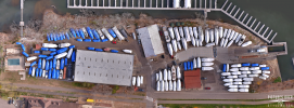
Here's example of a 231 image via Autel mission (3D/crisscross) processed via webodm (free)
StillwaterMarina2D_220_110921awaw.png

If you have not done so, you sign up for a trial of software/platforms such as DD, pix4d, etc and upload a subset of your missions to see how it works.

Otoh, if you are stiching panos, 180, 360, sphereical, etc, 1000+ images is a lot, however there are numerous tools from Adobe PS among others, and a free tool from Microsoft called ICE (Image Composite Editor) that is a great resource.
 
Last edited:

Latest threads

Members online

Forum statistics

Threads
11,280
Messages
102,953
Members
9,878
Latest member
Elio-Italy