Welcome, Autel Pilots!
Join our free Autel drone community today!
Join Us

Evo 2 Pro suicides itself into a tree...

Shain Rufus

Well-Known Member
Joined
Oct 20, 2021
Messages
47
Reaction score
8
Age
47
Been flying for almost 8 years and this is the second drone crash I have had. The first being a DJI mavic Air that RTH on its own into trees due to losing signal from the controller while standing 7 feet from it. This time, I was flying the Autel Evo 2 pro. Flown this for over a year now and its been faithful until today. Arrived at the home today for the photoshoot. Went through my pre-flight checklist...everything good. Launched the drone, got it into the first picture position and snapped the image at about 5 feet from the ground under a tree. Nothing different...I have done this over 100 times. It did not immediately take the picture however. I have had this issue happen before and it sometimes would take about 5 or 7 seconds and then it would register. This time however it did not. It took about 25 seconds and it finally took it. Then I preceded to move the drone into the next position. However, I noticed the drone immediately turn away from me...and then proceed to take off vertically as if it were RTH for some reason. I could not do anything via the RC as it ignored all inputs. The controller was still connected to it as well as the visual system. It ignored its obstacle avoidance systems and proceeded to go into the tree limbs and then crash.

So now I'm on hold with their customer service department. I hope NO ONE has to do this as I'm convinced they have ONLY one employee managing their phones. I started at position 8 in their que and I'm now finally number 1 at almost 2 hours now on hold... Thats pathetic. I'm sure this is going to be considered "pilot error" because DJI tried to weasel out of it till I posted videos and contacted the BBB. Just irritates me when crap like this happens. I can accept pilot error if it was my mistake...but when you have no explanation and the drone just does what it wants to do...its frustrating.
They NEED to give us the option to turn off the RTH function. DJI does and Autel needs to as well. Someone is going to get hurt...

I'll keep everyone posted on how this updates if anyone is interested.
 

Attachments

  • Screenshot_20230106_134341_Call.jpg
    Screenshot_20230106_134341_Call.jpg
    5.6 KB · Views: 33
  • Like
Reactions: ply17410
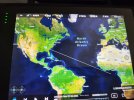
After looking at the flight records I can see the Evo 2 did the EXACT same thing the dji mavic air did years ago. It confused itself to be somewhere else. Look at the flight record map. It assumed I was off the coast of Africa...and looking at the home I was at...that is the direction the drone turned and faced when it proceeded to rise up into the tree WHILE ignoring controller commands.
Here is a YouTube video showing the progress:

Autel Crash
 

Attachments

  • 20230106_150444.jpg
    20230106_150444.jpg
    3.1 MB · Views: 30
Last edited:
  • Like
Reactions: ply17410
Been flying for almost 8 years and this is the second drone crash I have had. The first being a DJI mavic Air that RTH on its own into trees due to losing signal from the controller while standing 7 feet from it. This time, I was flying the Autel Evo 2 pro. Flown this for over a year now and its been faithful until today. Arrived at the home today for the photoshoot. Went through my pre-flight checklist...everything good. Launched the drone, got it into the first picture position and snapped the image at about 5 feet from the ground under a tree. Nothing different...I have done this over 100 times. It did not immediately take the picture however. I have had this issue happen before and it sometimes would take about 5 or 7 seconds and then it would register. This time however it did not. It took about 25 seconds and it finally took it. Then I preceded to move the drone into the next position. However, I noticed the drone immediately turn away from me...and then proceed to take off vertically as if it were RTH for some reason. I could not do anything via the RC as it ignored all inputs. The controller was still connected to it as well as the visual system. It ignored its obstacle avoidance systems and proceeded to go into the tree limbs and then crash.

So now I'm on hold with their customer service department. I hope NO ONE has to do this as I'm convinced they have ONLY one employee managing their phones. I started at position 8 in their que and I'm now finally number 1 at almost 2 hours now on hold... Thats pathetic. I'm sure this is going to be considered "pilot error" because DJI tried to weasel out of it till I posted videos and contacted the BBB. Just irritates me when crap like this happens. I can accept pilot error if it was my mistake...but when you have no explanation and the drone just does what it wants to do...its frustrating.
They NEED to give us the option to turn off the RTH function. DJI does and Autel needs to as well. Someone is going to get hurt...

I'll keep everyone posted on how this updates if anyone is interested.

I don't understand, why would you use a drone to take pictures 5' AGL under a tree? A handheld camera is much better suited for that type of project unless the tree happens to be in the middle of a swamp or something like that.

More than likely the drone lost its GPS signal due to the tree or suffered a compass error and tried to correct it via RTH. Did you take off from cement? I have been flying various things for almost 20yrs and have never had the problems you describe but I also don't spend any time under trees or that close to the ground most of the time. The only time I am under tree cover is when I am landing or taking off and I get out into the open as quickly as possible.

It is very important for drones that they maintain a clear line of sight to the controller AND to the sky for GPS synch; its also not a good idea to stay within 20' or so of the ground due to the increased potential for compass errors from rebar and other sources. A drone is at its safest at least 100' AGL in wide open spaces.

I have had plenty of customers ask me to fly very low and close to the ground; I tell them if they want that kind of footage then they will need to pay for regular videography coverage or photography coverage; drones are great for many things; but they do have limitations.
I have been doing this type of Photography and videography for almost 8 years. Many of the places where I photograph are around trees. I've had this happen twice in 2 drones and it's a glitch of some sort. I've had the drone RTH before and I still could control it. This ignored ALL commands and the pause button. Nothing worked.

I understand how these craft work and how they receive signals from the rc and GPS as well as their visual systems. The tree coverage isn't as big of an issue as one may think. And when the drone loses GPS signal it uses the obstacle avoidance cameras to keep its position steady while it awaits connectivity. Fly under a cover structure and you will see.

And yes I could use a handheld gimble but why would I if I'm using the drone to get shots of a property. Time is money and if the drone can get a shot in under a minute versus setting up my ronin 2 and balancing the camera in 20 minutes...then I'll do the drone. As I said...it's worked for my business all these years and my clients are happy.

Yes I had a clear line of sight to the drone. I launched from concrete once it had a good signal as well. It wasn't windy and clear skies. No metal structures near nor any powerlines. 2 trees in the yard and both less than 80 feet tall with no leaf coverage.
 
  • Like
Reactions: ply17410
Yes I had a clear line of sight to the drone. I launched from concrete once it had a good signal as well.

I asked specifically about concrete because it has rebar in it, rebar has a high chance of causing compass malfunctions which is why I never launch from concrete. I always place my rugged case on grass if at all possible then I place the drone on top of it. Even then sometimes I've had compass error warnings in some scenarios such as parking garages. For parking garages I first place my case on the hood of my car then the drone on top of that to launch. While landing, I land as quickly as possible whenever parking garages or concrete are involved.

More than likely you had a compass calibration issue due to launching from concrete; neither OA nor GPS will save a drone if the compass malfunctions which is probably also why the location on the map went haywire. If the drone detects it before takeoff it will not let you takeoff and will put an alert on the screen. If it doesn't detect it before takeoff then it is pretty much always a total loss. IMU and compass calibration failures are pretty much unrecoverable.

This is also probably why you lost both the DJI and Autel drones in similar scenarios, all drones that I've ever flown are strongly susceptible to compass errors when concrete is involved. Sidewalks, driveways, and especially parking garages can all end in a crash if you launch from them. Regular pavement doesn't have this problem; I've even had compass warnings when there are buried powerlines nearby.
And yes I could use a handheld gimble but why would I if I'm using the drone to get shots of a property. Time is money and if the drone can get a shot in under a minute versus setting up my ronin 2 and balancing the camera in 20 minutes...then I'll do the drone. As I said...it's worked for my business all these years and my clients are happy.

I get what you are saying, and time is definitely money, that's also why I don't shoot residential real estate anymore; that industry is in a race to the bottom in my area, everything is going up except what RE agents are willing to pay, commercial real estate and construction is a whole different story, but it won't change the fact that using a drone for that type of work that close to the ground is far riskier for the drone. I do think if you start launching from grass and using the top of your case as your launch platform you will have better results. But there is always a chance of a compass calibration error mid-flight due to something buried in the ground since your drones spend so much time near the ground.

Also, totally unrelated but one big time saver for when you do need to use the Ronin is to get the Ronin bag that lets you carry it fully assembled. I can complete the setup, balancing, and calibration for my RS2 in under a minute thanks to that bag. I don't think I've broken down my RS2 in over a year now. I have a dedicated gimbal camera and the gimbal stays assembled so all I need to do is adjust the tilt axis occasionally depending on what lens I'm using.
 
  • Like
Reactions: bedellrt
I asked specifically about concrete because it has rebar in it, rebar has a high chance of causing compass malfunctions which is why I never launch from concrete. I always place my rugged case on grass if at all possible then I place the drone on top of it. Even then sometimes I've had compass error warnings in some scenarios such as parking garages. For parking garages I first place my case on the hood of my car then the drone on top of that to launch. While landing, I land as quickly as possible whenever parking garages or concrete are involved.

More than likely you had a compass calibration issue due to launching from concrete; neither OA nor GPS will save a drone if the compass malfunctions which is probably also why the location on the map went haywire. If the drone detects it before takeoff it will not let you takeoff and will put an alert on the screen. If it doesn't detect it before takeoff then it is pretty much always a total loss. IMU and compass calibration failures are pretty much unrecoverable.

This is also probably why you lost both the DJI and Autel drones in similar scenarios, all drones that I've ever flown are strongly susceptible to compass errors when concrete is involved. Sidewalks, driveways, and especially parking garages can all end in a crash if you launch from them. Regular pavement doesn't have this problem; I've even had compass warnings when there are buried powerlines nearby.


I get what you are saying, and time is definitely money, that's also why I don't shoot residential real estate anymore; that industry is in a race to the bottom in my area, everything is going up except what RE agents are willing to pay, commercial real estate and construction is a whole different story, but it won't change the fact that using a drone for that type of work that close to the ground is far riskier for the drone. I do think if you start launching from grass and using the top of your case as your launch platform you will have better results. But there is always a chance of a compass calibration error mid-flight due to something buried in the ground since your drones spend so much time near the ground.

Also, totally unrelated but one big time saver for when you do need to use the Ronin is to get the Ronin bag that lets you carry it fully assembled. I can complete the setup, balancing, and calibration for my RS2 in under a minute thanks to that bag. I don't think I've broken down my RS2 in over a year now. I have a dedicated gimbal camera and the gimbal stays assembled so all I need to do is adjust the tilt axis occasionally depending on what lens I'm using.
I have never seen issues from launching on concrete. Matter of fact the first time something like this happened there was no concrete. Secondly if it were a RTH due to compass calibration issues then the drone would NOT refuse inputs. I have seen issues similar with compass calibration issues while in air and it still allowed flight control. This situation ignored ALL inputs WHILE staying connected to the RC. Construction codes around our neck of the woods don't require rebar anyway so this isn't an issue. Regardless...the drone did not act erratic nor should it ignore flight commands unless something else was wrong. The ONLY thing it did due while sitting in position for the first shot was delaying the first picture command that was sent for an extended time.
As far as in the ronin...its already assembled. I just have to load the camera and balance it which must be done on a flat surface...which mostly requires I go inside due to exterior terrain not being flat. I get your point...I really do but this isn't an issue with magnetic interference or compass problems. I have those situations pop up rarely...but in ALL of those situations I was able to control the drone. This did not. It ignored everything as if the controller was disconnected WHILE being connected.

And as far as in doing real estate...I do it because I enjoy doing it. I'm not out there to climb the ladder to be at the top. I do it because its what I love to do. Sure I could be doing bigger and more profitable things but thats not what I'm in it for.
 
Compass errors generally are only an issue on startup when the craft gets it's initial reading. A compass error will usually manifest as a "toilet bowl" flight pattern as the IMU strains to regain its bogus compass heading leading to an out of control spiral. Furthermore, there are differences between loss of connection from the controller RTH and low battery RTH. You still have control over a low battery RTH but a loss of control RTH, the aircraft just does its default attempt to return to the home point until a control signal has been regained by the aircraft. Obstacle avoidance around trees sometimes works (as when the tree is full of leaves) and sometimes doesn't (when the tree is bare and just has random skinny branches). It sounds like you encountered the loss of control signal RTH and the branches of the tree didn't have enough mass to trigger the OA. I would take up the case of why you lost signal from that distance in the first place with Autel.
 
  • Like
Reactions: Shain Rufus
Compass errors generally are only an issue on startup when the craft gets it's initial reading. A compass error will usually manifest as a "toilet bowl" flight pattern as the IMU strains to regain its bogus compass heading leading to an out of control spiral. Furthermore, there are differences between loss of connection from the controller RTH and low battery RTH. You still have control over a low battery RTH but a loss of control RTH, the aircraft just does its default attempt to return to the home point until a control signal has been regained by the aircraft. Obstacle avoidance around trees sometimes works (as when the tree is full of leaves) and sometimes doesn't (when the tree is bare and just has random skinny branches). It sounds like you encountered the loss of control signal RTH and the branches of the tree didn't have enough mass to trigger the OA. I would take up the case of why you lost signal from that distance in the first place with Autel.
That's what I'm currently working on with them. I'm sending it Monday and fairly confident it will be expensive to repair. I'm not sure what took place due to the above stated parameters but that's what I felt happened. It is odd though that it showed still connected and the video feed connected as well. I don't have a screenshot of the situation as it was over in seconds. However the first thing I looked at was controller connection strength and it was full bars. Doesn't mean it couldn't have taken place...the trick is determining why. though I have never tested the situation before...I'm curious if the distance limit of 1500ft came into play here since for a moment the drone thought it was off the coast of Africa. I'm not sure what happens if the drone finds itself outside of the range. I know what it does when reaching it...but never tested when its outside the range. But even IF it does a RTH...I would expect to be able to control the drone manually.
I do wish they would give us the ability to turn off RTH from the settings and set the drone to hover IF it loses connection like DJI does. This would remedy situations like this in the future.
 
After looking at the flight records I can see the Evo 2 did the EXACT same thing the dji mavic air did years ago. It confused itself to be somewhere else. Look at the flight record map. It assumed I was off the coast of Africa...and looking at the home I was at...that is the direction the drone turned and faced when it proceeded to rise up into the tree WHILE ignoring controller commands.
Here is a YouTube video showing the progress:

Autel Crash
These strange flight 'paths' are not uncommon with my drone. If I see such a path appearing I land immediately and reboot both the drone and the controller. I notice that if I am in a new location and do a compass calibration then these paths will be triggered but things get sorted out after rebooting a couple of times. I wrote to Autel after the first couple of times it happened but received no response.
 
  • Like
Reactions: Shain Rufus
So as an update...I haven't been told as to what happened with the drone. Emails have been ignored other than the invoice for repair that was sent which was for 2 arms and the black internal housing. I'm not too hopeful though on getting answers as the last question I had in regards to updates was answered after 6 months.
 
After looking at the flight records I can see the Evo 2 did the EXACT same thing the dji mavic air did years ago. It confused itself to be somewhere else. Look at the flight record map. It assumed I was off the coast of Africa...and looking at the home I was at...that is the direction the drone turned and faced when it proceeded to rise up into the tree WHILE ignoring controller commands.
Here is a YouTube video showing the progress:

Autel Crash
I can tell you that GPS coordinates 0,0 are just off the coast of Africa (A spot called Null Island, off the coast of Guinea). Exactly where your drone was headed. I use Skyebrowse for 3D mapping, and some of my videos haven't had a decodable .*** file (the GPS location files) attached for some reason, and the map always shows the center point right off the coast of Africa. Sounds like your EVO was on a mission to Africa...which somehow it saw as its RTH location.
 

Attachments

  • nullisland.jpg
    nullisland.jpg
    67.6 KB · Views: 15
Received the bird back from repairs. No info on why it flew away. I have asked again in an email and I'll update once/if I hear back.
As far as flying after making sure everything is up to date...it handles a bit odd. First I had to completely change all of the EXP and Sensitive flight settings as those were making the drone fly crazy. It would flight left quickly but then crawl to the right. Was very odd and not sure why all of a sudden the original settings I had fixed up were now Greek to the drone.

Once I fixed the flight settings I still see that the camera can't stay level as it has always been a problem since day 1. Anyone else have this issue? I calibrate it and its good for half a flight but then it gets tilted. Not bad...but definitely not level. Just for comparisons I took out my mavic air 2 and the Phantom 4 pro...even after being boxed up for months...no camera stability problems. But every flight with the Autel it gets tilted after a little bit in the air.

Another thing...and this is just an annoying quirk that has been with the drone since day one but I'm curious if anyone else has issues with this. No matter what setting I put the drone to and no matter what speed it is set too...ascending up either goes up by a little or a HUGE amount. I find that I just want to go up about a foot and sometimes it shoots up by 5 or 7 feet. Other times it goes up about a foot like I need it to do. I've tried to see if slightly pushing the stick up or pumping it up for a split second makes a difference and most of the time it doesn't. What I can't understand is why none of the flight settings allow me to adjust this speed of ascent. Any ideas? I've been flying for almost 8 years and this is the only drone I have had that has these type of quirks. Even in the slower tripod like mode it ascends quickly.
 
Been flying for almost 8 years and this is the second drone crash I have had. The first being a DJI mavic Air that RTH on its own into trees due to losing signal from the controller while standing 7 feet from it. This time, I was flying the Autel Evo 2 pro. Flown this for over a year now and its been faithful until today. Arrived at the home today for the photoshoot. Went through my pre-flight checklist...everything good. Launched the drone, got it into the first picture position and snapped the image at about 5 feet from the ground under a tree. Nothing different...I have done this over 100 times. It did not immediately take the picture however. I have had this issue happen before and it sometimes would take about 5 or 7 seconds and then it would register. This time however it did not. It took about 25 seconds and it finally took it. Then I preceded to move the drone into the next position. However, I noticed the drone immediately turn away from me...and then proceed to take off vertically as if it were RTH for some reason. I could not do anything via the RC as it ignored all inputs. The controller was still connected to it as well as the visual system. It ignored its obstacle avoidance systems and proceeded to go into the tree limbs and then crash.

So now I'm on hold with their customer service department. I hope NO ONE has to do this as I'm convinced they have ONLY one employee managing their phones. I started at position 8 in their que and I'm now finally number 1 at almost 2 hours now on hold... Thats pathetic. I'm sure this is going to be considered "pilot error" because DJI tried to weasel out of it till I posted videos and contacted the BBB. Just irritates me when crap like this happens. I can accept pilot error if it was my mistake...but when you have no explanation and the drone just does what it wants to do...its frustrating.
They NEED to give us the option to turn off the RTH function. DJI does and Autel needs to as well. Someone is going to get hurt...

I'll keep everyone posted on how this updates if anyone is interested.
I had exactly the same thing happen to me today! Landed in the talest tree in the town home complex. I must get it down somehow before it falls of its own accord and, God forbid, hits someone or a pet. And I have had similar problems reaching anyone at Autel. I am about to bail and try another drone by another company.
 
I find that I just want to go up about a foot and sometimes it shoots up by 5 or 7 feet. Other times it goes up about a foot like I need it to do. I've tried to see if slightly pushing the stick up or pumping it up for a split second makes a difference and most of the time it doesn't. What I can't understand is why none of the flight settings allow me to adjust this speed of ascent.

I have also noticed this behavior on my EVO 2. Have you noticed this behavior gets worse on windy days? Many drones use internal air pressure for measurement of altitude changes. On windy days the air pressure difference can be affected by minimal wind offsets that make the drone misunderstand how fast or slow it rises or descends.

There are two flight modes I used in the past that seems to smooth this out. One is called "Dual Stability" and the other is "Precision Flight". Depending on the weather and intended movements this can help you make the drone move slower. Modes can be turned on and off while in the air.

I agree when you will say this could have been made more elaborate and clear or even more accessible by software design.
 
Last edited:
Once I fixed the flight settings I still see that the camera can't stay level as it has always been a problem since day 1. Anyone else have this issue? I calibrate it and its good for half a flight but then it gets tilted. Not bad...but definitely not level. Just for comparisons I took out my mavic air 2 and the Phantom 4 pro...even after being boxed up for months...no camera stability problems. But every flight with the Autel it gets tilted after a little bit in the air.

Now I will answer to your tilted horizon question. I have noticed, that the aircraft must be in an absolute level position when the gimbal calibrates after power up. The stupid part is, every time a new battery is inserted out in the field the gimbal will calibrate again. In the field you are never 100% level, unless you carry a table with adjustable legs around and use that as takeoff point.

What happens is the camera's horizon gets calibrated to the heading before takeoff but not exactly to the pitch, and then if you change heading when airborne the tilted pitch shows up as horizon. One would expect the IMU vs gimbal should correct this via software but no it does not, also after several firmware releases this is still happening.

Solution: land aircraft at same spot as last takeoff, turn off aircraft, manually rotate aircraft heading by some 90 degree on the ground, turn aircraft back on, let gimbal do the initialization and fly to the same position, take a picture to compare.

Solution 2: Have a plate or table top with you that can be leveled in 2 directions, just for the calibration process.
 
Last edited:
  • Like
Reactions: G_G
Now I will answer to your tilted horizon question. I have noticed, that the aircraft must be in an absolute level position when the gimbal calibrates after power up. The stupid part is, every time a new battery is inserted out in the field the gimbal will calibrate again. In the field you are never 100% level, unless you carry a table with adjustable legs around and use that as takeoff point.

What happens is the camera's horizon gets calibrated to the heading before takeoff but not exactly to the pitch, and then if you change heading when airborne the tilted pitch shows up as horizon. One would expect the IMU vs gimbal should correct this via software but no it does not, also after several firmware releases this is still happening.

Solution: land aircraft at same spot as last takeoff, turn off aircraft, manually rotate aircraft heading by some 90 degree on the ground, turn aircraft back on, let gimbal do the initialization and fly to the same position, take a picture to compare.

Solution 2: Have a plate or table top with you that can be leveled in 2 directions, just for the calibration process.

These all sound like V2 or V3 issues, you did not mention what version you have, but I have a V1 with the original FW it shipped with (have never updated) and I don't have a single one of these issues, no horizon problems, no GPS problems, and no flight elevation change issues.

Occasionally the horizon will tilt after executing a turn, orbit, etc, but within a few seconds it levels back out, I have even had to take off occasionally from surfaces that are not perfectly level and it just fixes the horizon after takeoff. I used to pay particular attention to ensuring the takeoff surface was perfectly level, but these days I just look for the most convenient spot and shoot for somewhat level vs perfectly level.

IMO though the OP will continue to lose drones while using them in the way they have chosen to use them, drones simply are not a good fit for that type of project (flying low close to and underneath tree cover) so the occasional loss of the drone must be calculated in the client's service proposals to stay profitable. Drone's real power is 100'+ AGL showing the big picture, its just not the right tool for that type of job.
 
  • Like
Reactions: KANSAS KILLSHOT
Been flying for almost 8 years and this is the second drone crash I have had. The first being a DJI mavic Air that RTH on its own into trees due to losing signal from the controller while standing 7 feet from it. This time, I was flying the Autel Evo 2 pro. Flown this for over a year now and its been faithful until today. Arrived at the home today for the photoshoot. Went through my pre-flight checklist...everything good. Launched the drone, got it into the first picture position and snapped the image at about 5 feet from the ground under a tree. Nothing different...I have done this over 100 times. It did not immediately take the picture however. I have had this issue happen before and it sometimes would take about 5 or 7 seconds and then it would register. This time however it did not. It took about 25 seconds and it finally took it. Then I preceded to move the drone into the next position. However, I noticed the drone immediately turn away from me...and then proceed to take off vertically as if it were RTH for some reason. I could not do anything via the RC as it ignored all inputs. The controller was still connected to it as well as the visual system. It ignored its obstacle avoidance systems and proceeded to go into the tree limbs and then crash.

So now I'm on hold with their customer service department. I hope NO ONE has to do this as I'm convinced they have ONLY one employee managing their phones. I started at position 8 in their que and I'm now finally number 1 at almost 2 hours now on hold... Thats pathetic. I'm sure this is going to be considered "pilot error" because DJI tried to weasel out of it till I posted videos and contacted the BBB. Just irritates me when crap like this happens. I can accept pilot error if it was my mistake...but when you have no explanation and the drone just does what it wants to do...its frustrating.
They NEED to give us the option to turn off the RTH function. DJI does and Autel needs to as well. Someone is going to get hurt...

I'll keep everyone posted on how this updates if anyone is interested.
Shane,

Your situation, while in flight, sucks.

Autel does have the ability to cancel RTH on the SE Controller (or at least mine does). I don’t think I got the only one in the world with this feature though.

I think the underlying problem for your in flight situation was the aircraft wasn’t responding, so even if you knew where the cancel RTH button was, you would not have been able to control the rogue drone.

I did learn that if I put my EVO II Pro into RTH, I can still control the aircraft and maneuver it to avoid objects; but if it goes into RTH, say for a low battery (which was my case), I cannot control the drone without cancelling the RTH with the red cancel button in the top center of the controller screen.

The red button is positioned on the screen poorly though. The position hides it behind the GEOCORDs. I can still tap the button on the controller screen but it is fairly well hidden, behind the GEOCORDs.

I hope things worked out well with Autel Customer Service.
 
These all sound like V2 or V3 issues, you did not mention what version you have, but I have a V1 with the original FW it shipped with (have never updated) and I don't have a single one of these issues, no horizon problems

@herein2021, now you got me interested in finding out how you can have the same aircraft but never having any of these issues. I did do a firmware update once, that was more than a year ago. Our main aircraft has some of the mentioned issues occasionally and is equipped as written below, I never checked the details on our secondary aircraft:

Non fatal Issues I am referring to:

1. When ascending slowly with certain wind pressure sudden jumps in altitude occur, only if you press the stick up.
2. From highest speed forward movement to full stop, the aircraft moves up a few feet after horizontally coming to a halt.
3. The horizon gets tilted and gimbal doesn't self correct. I can manually fix this by a changed heading before takeoff.


EVO 2 Pro V1

Gimbal Model: XT705
Gimbal Mode: "Stabilized"
Gimbal Pitch EXP Sensitivity: "100"
Android App Version: V1.0.72
iOS App Version: V1.15.1
Camera Version: V0.2.32.32
Aircraft Flight Control: V0.0.4.57
Aircraft Image Transmission: V1.1.1.47
 
Last edited:
@herein2021, now you got me interested in finding out how you can have the same aircraft but never having any of these issues. I did do a firmware update once, that was more than a year ago. Our main aircraft has some of the mentioned issues occasionally and is equipped as written below, I never checked the details on our secondary aircraft:

Non fatal Issues I am referring to:

1. When ascending slowly with certain wind pressure sudden jumps in altitude occur, only if you press the stick up.
2. From highest speed forward movement to full stop, the aircraft moves up a few feet after horizontally coming to a halt.
3. The horizon gets tilted and gimbal doesn't self correct. I can manually fix this by a changed heading before takeoff.


EVO 2 Pro V1

Gimbal Model: XT705
Gimbal Mode: "Stabilized"
Gimbal Pitch EXP Sensitivity: "100"
Android App Version: V1.0.72
iOS App Version: V1.15.1
Camera Version: V0.2.32.32
Aircraft Flight Control: V0.0.4.57
Aircraft Image Transmission: V1.1.1.47

It could just be a quality control problem, maybe some of your components are slightly out of allowable specs. That is not to say that mine for does not have its own long list of problems, just not the ones that you describe.

Also, I am using the Apple version of the app, not sure if it makes a difference, I will check to see what firmware version mine is running when I get a chance.
 
  • Like
Reactions: G_G and uas_gian
These all sound like V2 or V3 issues, you did not mention what version you have, but I have a V1 with the original FW it shipped with (have never updated) and I don't have a single one of these issues, no horizon problems, no GPS problems, and no flight elevation change issues.

Occasionally the horizon will tilt after executing a turn, orbit, etc, but within a few seconds it levels back out, I have even had to take off occasionally from surfaces that are not perfectly level and it just fixes the horizon after takeoff. I used to pay particular attention to ensuring the takeoff surface was perfectly level, but these days I just look for the most convenient spot and shoot for somewhat level vs perfectly level.

IMO though the OP will continue to lose drones while using them in the way they have chosen to use them, drones simply are not a good fit for that type of project (flying low close to and underneath tree cover) so the occasional loss of the drone must be calculated in the client's service proposals to stay profitable. Drone's real power is 100'+ AGL showing the big picture, its just not the right tool for that type of job.
You make it sound as though this is an issue I run into all the time. Lol. I've only had this drone do this...and many MANY other issues. Please explain to me where Autel or even DJI claim their drone use is not for low flying usage? I'm really curious
 

Latest threads

Members online

Forum statistics

Threads
11,495
Messages
104,193
Members
10,265
Latest member
QinuxHydroPure