Welcome, Autel Pilots!
Join our free Autel drone community today!
Join Us

Doing Manual Coords on the RS2

He posted that to give closure, but I have a feeling it will come back since it came out of nowhere and resolved on its own out of nowhere and has happened once before.
Okay, thanks for the update. I don't remember if it was discussed, but, always use the domain name and not the IP for Emlid Caster. There have been times when Emlid would change IPs and folks using the IP would not be able to connect. The domain name always points to the current IP. Probably not your issue, but just in case.
 
  • Like
Reactions: jaja6009
Local NTRIP works like this.

You setup your base on a known point. This point could be a survey benchmark, a point you made in OPUS or PPK or a point you averaged with RTN (NTRIP or VRS).

Use a wifi hotspot and then connect your Evo 2 RTK Controller and your base to this wifi. Corrections are now sent over wifi. The range is limited and you must have controller, wifi hotspot and base in close proximity (10-20 feet, but I never tested it for range really).
I have found using the RS2+ Local NTRIP option and WiFi connecting the RS2+ to EVO 2 Smart Controller as the most stable and consistent way to fly my RTK drone.

Create/Survey a "Known point"

I place a GCP on the ground. I have 2 different options to survey the location of the GCP. I either use my EOS Arrow Gold GNSS RTK receiver system to survey the location of the GCP or place the Emlid RS2+ GNSS RTK receiver system in a tripod over the GCP. Using Emlid Flow App, set the Base Mode to AVE FIX for 10-15 minutes. Finally, I set the Base Mode to Manual and input the Latitude, Longitude, and Ellipsoidal Height of the known point and apply antenna height.

Steps:

1. I connect the RS2+ using my iPad Pro via RS2+ WiFi
2. For the Base mode use Average FIX configured for 10 min (sometimes 15 min)
3. After 10 or 15 minutes, capture the Position data
4. Switch from Average FIX to Manual for the Coordinates entry method
5. Input the Coordinates generated from Step 4 and set the Antenna height (2.0m) then saved.
6. Reconnect to the RS2+ to the iPad Pro via RaptorRS2Plus WiFi.
7. Set the RS2+ Correction output to Local NTRIP
8. Connect the Autel Smart Controller to the RS2+ via RS2+ WiFi.
9. Smart Controller RTK Settings: Select Custom (NTRIP) Network

RTK IP Host:
192.168.42.1
Port: 2101
Account: reach
Password: emlidreach
Mountpoint: REACH

10. Hit Login
11. RTK Network Status:
Connection successful
12. Wait for RTK Positioning to go from SINGLE to FLOAT to FIX.
 
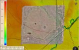
Also what are you looking for with the thermal?
The survey area covers a portion of the Hockley Salt Dome. The caprock (overlies the salt) is only a few hundred feet below the surface. I wanted to see if any heat from the underlying salt dome and associated caprock manifests itself at the surface along lineations. This is more of an academic survey, although this is an active oil field and they mine the salt.
 

Attachments

  • 2023-01-20_14-27-51.jpg
    2023-01-20_14-27-51.jpg
    289.8 KB · Views: 5
  • Like
Reactions: jmason702
I have found using the RS2+ Local NTRIP option and WiFi connecting the RS2+ to EVO 2 Smart Controller as the most stable and consistent way to fly my RTK drone.

Create/Survey a "Known point"

I place a GCP on the ground. I have 2 different options to survey the location of the GCP. I either use my EOS Arrow Gold GNSS RTK receiver system to survey the location of the GCP or place the Emlid RS2+ GNSS RTK receiver system in a tripod over the GCP. Using Emlid Flow App, set the Base Mode to AVE FIX for 10-15 minutes. Finally, I set the Base Mode to Manual and input the Latitude, Longitude, and Ellipsoidal Height of the known point and apply antenna height.

Steps:

1. I connect the RS2+ using my iPad Pro via RS2+ WiFi
2. For the Base mode use Average FIX configured for 10 min (sometimes 15 min)
3. After 10 or 15 minutes, capture the Position data
4. Switch from Average FIX to Manual for the Coordinates entry method
5. Input the Coordinates generated from Step 4 and set the Antenna height (2.0m) then saved.
6. Reconnect to the RS2+ to the iPad Pro via RaptorRS2Plus WiFi.
7. Set the RS2+ Correction output to Local NTRIP
8. Connect the Autel Smart Controller to the RS2+ via RS2+ WiFi.
9. Smart Controller RTK Settings: Select Custom (NTRIP) Network

RTK IP Host:
192.168.42.1
Port: 2101
Account: reach
Password: emlidreach
Mountpoint: REACH

10. Hit Login
11. RTK Network Status:
Connection successful
12. Wait for RTK Positioning to go from SINGLE to FLOAT to FIX.

Are you averaging with an RTN (NTIP or VRS) correction or just using the normal averaging?

For better Absolute accuracy, my workflow would be to PPK or OPUS the known point for the base. Whether the project needs it or not, my OCD wants absolute accuracy and averaging Single without corrections is going to be above meter absolute accuracy.

I am only adding this for others reading, so that they know, I am in no way questioning your workflow. Everybody's workflow needs to meet THEIR goals.
 

Latest threads

Members online

Forum statistics

Threads
11,290
Messages
103,014
Members
9,899
Latest member
rudymuller