Welcome, Autel Pilots!
Join our free Autel drone community today!
Join Us

Too good to be true?

agrofactory

Member
Joined
Jan 13, 2022
Messages
23
Reaction score
11
Hi. I've been performing several flights for my company in order to get a proper workflow to obtain good accuracy in the areas surveyed. My equipment is the EVO II RTK + RS2 base station and the software Agisoft Metashape. It turns out that from a couple flights ago I'm getting values for the errors that are too small to believe them. I'm talking less than a centimeter.

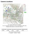
Regarding the flight: small area (2.2 ha), 100m altitude, 36km/h;

My workflow is the usual:
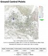
- Take some GCP with the RS2 connected to the local NTRIP on a pole.
- Place the RS2 as a base and connect the EVO to its corrections.
- Flight.
- On Agisoft:
  • Align photos (with rolling shutter compensation checked)
  • Load CPG and relocate if necessary.
  • Optimize cameras with fit additional corrections checked.
And the result is in this case an error of 0.7 cm. Is this really possible? How do I know when the results are within the expected parameters? I know that even a broken clock is right twice a day...

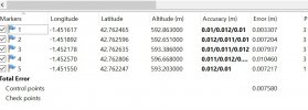
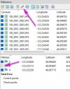
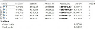
I attach some pics from the error distribution in order to explain myself.

Thanks for your comments. 👋
 

Attachments

  • cameralocations.jpg
    cameralocations.jpg
    584.8 KB · Views: 42
  • gcplocations.jpg
    gcplocations.jpg
    580.7 KB · Views: 42
It looks like I don't have any checkpoint. I attach the full report.
Can you change 2 GCPs to checkpoints?
In Metashape, you simply uncheck a marker before you Optimize Cameras and they will be processed as Check Points rather than Control Points. The error reported by the Check Point after optimization will give you a better idea of your global accuracy.
 

Attachments

  • 2.jpg
    2.jpg
    67.8 KB · Views: 13
  • Like
Reactions: agrofactory
In Metashape, you simply uncheck a marker before you Optimize Cameras and they will be processed as Check Points rather than Control Points. The error reported by the Check Point after optimization will give you a better idea of your global accuracy.
Copy. Checkpoint error around 5 cm.

Can you change 2 GCPs to checkpoints? and try a larger map, like 30 to 50acres

I have limited experience with Metashape

Looks really good non the less
There you go. The next time I flight a larger area.
 

Attachments

  • Captura de pantalla 2022-06-22 073102.jpg
    Captura de pantalla 2022-06-22 073102.jpg
    74.2 KB · Views: 8
Copy. Checkpoint error around 5 cm.


There you go. The next time I flight a larger area.
This is our experience as well on projects under about 30 acres but something you will experience as you visit larger sites is that those numbers will continually go up. Our projects are anywhere from 30-300 acres and our checkpoint errors are anywhere from 2-7cm. Elevation change and altitude also contribute to this as it does with every drone.
 

Latest threads

Members online

No members online now.

Forum statistics

Threads
11,226
Messages
102,644
Members
9,818
Latest member
redwingaerials