- Joined
- Jan 13, 2022
- Messages
- 23
- Reaction score
- 11
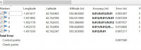
Hi. I've been performing several flights for my company in order to get a proper workflow to obtain good accuracy in the areas surveyed. My equipment is the EVO II RTK + RS2 base station and the software Agisoft Metashape. It turns out that from a couple flights ago I'm getting values for the errors that are too small to believe them. I'm talking less than a centimeter.
Regarding the flight: small area (2.2 ha), 100m altitude, 36km/h;
My workflow is the usual:
- Take some GCP with the RS2 connected to the local NTRIP on a pole.
- Place the RS2 as a base and connect the EVO to its corrections.
- Flight.
- On Agisoft:
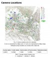
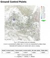
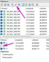
I attach some pics from the error distribution in order to explain myself.
Thanks for your comments.
Regarding the flight: small area (2.2 ha), 100m altitude, 36km/h;
My workflow is the usual:
- Take some GCP with the RS2 connected to the local NTRIP on a pole.
- Place the RS2 as a base and connect the EVO to its corrections.
- Flight.
- On Agisoft:
- Align photos (with rolling shutter compensation checked)
- Load CPG and relocate if necessary.
- Optimize cameras with fit additional corrections checked.
I attach some pics from the error distribution in order to explain myself.
Thanks for your comments.


