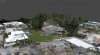
I'm at work, so I opened the last project I did here. When I click on capture, I get the blubble around the XYZ axis, the square at the end of the project and the dull gray background. It just looks bleh.... I still have a lot to learn about Metashape, but I haven't figured out how to improve there. Unless those are added in post processing.


You are using an out of date browser. It may not display this or other websites correctly.
You should upgrade or use an alternative browser.
You should upgrade or use an alternative browser.
Explorer App's Mission feature and My First Photogrammetry with the Evo
- Thread starter Ansia
- Start date
Jagerbomb52
Well-Known Member

Is it faster than Metashape? I just learned how to make video fly bys with Metashape. I was trying to figure out how you got the multicolor background.After 18 hours of it still not half ways done in Agisoft Metashape Professional I shut it down and did the who thing in Pix4D desktop. Just learning that program and have another 15 day trial to play around with it.
DadCorso80
Well-Known Member
- Joined
- Jul 4, 2018
- Messages
- 122
- Reaction score
- 65
- Age
- 47
☝Thats pretty cool! Is Metashape free or have a trial version? I've used Pix4D, just for orthomosaics, but like the capability to manipulate or refine the data as needed using the desktop program.
You have a 30 days trial and I believe the stand alone price is $179.☝Thats pretty cool! Is Metashape free or have a trial version? I've used Pix4D, just for orthomosaics, but like the capability to manipulate or refine the data as needed using the desktop program.
My company paid for mine, so I don't know how much they paid.
Jagerbomb52
Well-Known Member
I ended up using all the lowest settings in Agisoft and it took a couple of hours to complete. I uploaded the result to SketchFab if you want to look at it. Seems to have come out pretty well.
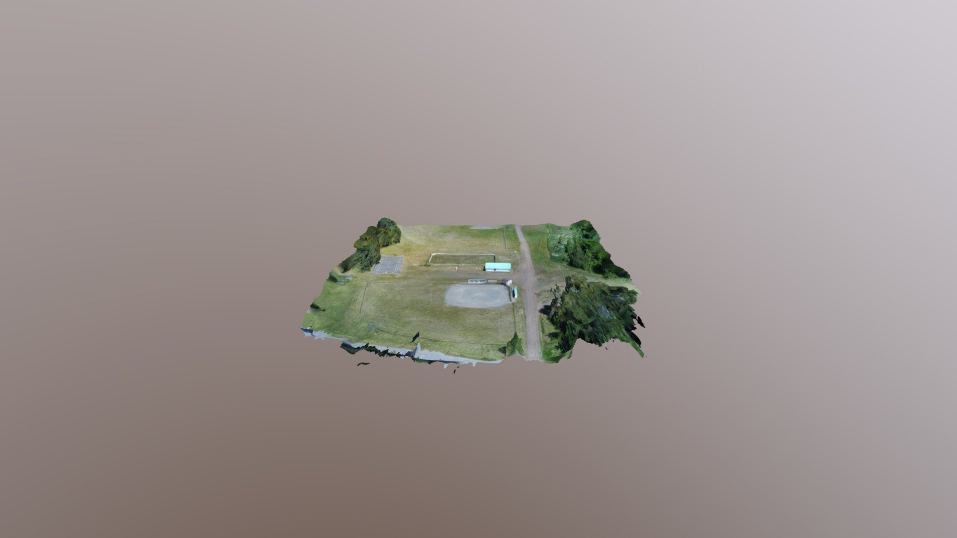
 sketchfab.com
BaseBall Field June 20th - 3D model by kbaerialphoto
Playing around with Pix4D - BaseBall Field June 20th - 3D model by kbaerialphoto
sketchfab.com
Looks pretty good. I would love to see a rendering in ultra high, but you need 128Gb of RAM and create the rendering in Dense Cloud in order to achieve that.I ended up using all the lowest settings in Agisoft and it took a couple of hours to complete. I uploaded the result to SketchFab if you want to look at it. Seems to have come out pretty well.
BaseBall Field June 20th - 3D model by kbaerialphoto
Playing around with Pix4D - BaseBall Field June 20th - 3D model by kbaerialphoto
Jagerbomb52
Well-Known Member
The one thing I never knew and will add next time is making sure in the options to have all three of these check marked for drone pictures.

I never have used those options as well. I followed the options given from the Agisoft webpage, and they specificly said to only check the first 2.The one thing I never knew and will add next time is making sure in the options to have all three of these check marked for drone pictures.
View attachment 4608
Jagerbomb52
Well-Known Member
I will try it this weekend and see if I get better results.I only posted that because I was watching some of this video and he suggested doing that. View attachment 4609
Fred
New Member
- Joined
- Sep 9, 2018
- Messages
- 3
- Reaction score
- 2
- Age
- 74
What mapping/modeling software did you use?As soon as I got home, I tried the new mission feature in the beta version of the Explorer app.
I still need to play with it, since I made some mistakes and it shows on the end result, but I'll get there. Anyways, here are the results. The 3D rendering ended up with a weird black circle around it, but that is probably my fault for cutting corners to get the model out before it was ready. I will have to do further testing.
View attachment 4584
View attachment 4581
View attachment 4582
Other than that, I say it looks pretty good. The orthomosaic in the other hand isn't really impressive. There is a lack of detail and definition. I don't know if it's because of the 12MP camera or I was to high.
View attachment 4583
The blurryness in the Orthomosaic is caused by the photos taken while the drone was turning. I will have to keep that in mind next time.
What do you guys think?
I use Agisoft Metashape for modeling. I used the Explorer beta app for mapping.What mapping/modeling software did you use?
So I added those check marks, removed the blurry photos and redid the rendering. It actually makes a world of difference. You can compare with my previous model. You can actually see the different fences that surround the basketball court and at the other side of the street.The one thing I never knew and will add next time is making sure in the options to have all three of these check marked for drone pictures.
View attachment 4608


Jagerbomb52
Well-Known Member
reportFunny no one else is gung ho over it but never the less I gave it a shot this morning with the IOS version and no go at this point.
Setting it up was easy then I pressed Fly and the small fly appears just above the bigger Fly.
I get a message "uploading waypoints 30%" right away but it stays at that percentage point then after roughly 1 minute the
message disappears and back with the Larger Fly again. I tried maybe 6 or seven times more with the same results.
The Evo was flying stationary at the minimum height stipulated (30 meters) like a lonesome cowboy.
Should I report to Autel or are they surveying this site for our experiences ?
Like the lonesome cowboy this Beta tryout is a close cousin.
Beachguy213
Member
- Joined
- Mar 29, 2019
- Messages
- 9
- Reaction score
- 0
- Age
- 51
Ok I am very new at thisAs soon as I got home, I tried the new mission feature in the beta version of the Explorer app.
I still need to play with it, since I made some mistakes and it shows on the end result, but I'll get there. Anyways, here are the results. The 3D rendering ended up with a weird black circle around it, but that is probably my fault for cutting corners to get the model out before it was ready. I will have to do further testing.
View attachment 4584
View attachment 4581
View attachment 4582
Other than that, I say it looks pretty good. The orthomosaic in the other hand isn't really impressive. There is a lack of detail and definition. I don't know if it's because of the 12MP camera or I was to high.
View attachment 4583
The blurryness in the Orthomosaic is caused by the photos taken while the drone was turning. I will have to keep that in mind next time.
What do you guys think?
When the drone is done with mission what program are you putting all the pictures together with or does the drone do that?
Agisoft MetashapeOk I am very new at this
When the drone is done with mission what program are you putting all the pictures together with or does the drone do that?
Any updates regarding uploading Waypoints? I couldn't upload mine while hovering about 20 feet up. I didn't think to try while it was right next to me.Funny no one else is gung ho over it but never the less I gave it a shot this morning with the IOS version and no go at this point.
Setting it up was easy then I pressed Fly and the small fly appears just above the bigger Fly.
I get a message "uploading waypoints 30%" right away but it stays at that percentage point then after roughly 1 minute the
message disappears and back with the Larger Fly again. I tried maybe 6 or seven times more with the same results.
The Evo was flying stationary at the minimum height stipulated (30 meters) like a lonesome cowboy.
Should I report to Autel or are they surveying this site for our experiences ?
Like the lonesome cowboy this Beta tryout is a close cousin.
Attachments
Similar threads
- Replies
- 5
- Views
- 515
- Replies
- 4
- Views
- 781
- Replies
- 4
- Views
- 997


