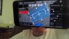
As soon as I got home, I tried the new mission feature in the beta version of the Explorer app.
I still need to play with it, since I made some mistakes and it shows on the end result, but I'll get there. Anyways, here are the results. The 3D rendering ended up with a weird black circle around it, but that is probably my fault for cutting corners to get the model out before it was ready. I will have to do further testing.


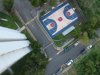
Other than that, I say it looks pretty good. The orthomosaic in the other hand isn't really impressive. There is a lack of detail and definition. I don't know if it's because of the 12MP camera or I was to high.

The blurryness in the Orthomosaic is caused by the photos taken while the drone was turning. I will have to keep that in mind next time.
What do you guys think?
I still need to play with it, since I made some mistakes and it shows on the end result, but I'll get there. Anyways, here are the results. The 3D rendering ended up with a weird black circle around it, but that is probably my fault for cutting corners to get the model out before it was ready. I will have to do further testing.
Other than that, I say it looks pretty good. The orthomosaic in the other hand isn't really impressive. There is a lack of detail and definition. I don't know if it's because of the 12MP camera or I was to high.
The blurryness in the Orthomosaic is caused by the photos taken while the drone was turning. I will have to keep that in mind next time.
What do you guys think?
Last edited: