Welcome, Autel Pilots!
Join our free Autel drone community today!
Join Us

Emlid Caster VS Local NTRIP

I have the Free trial of meta shape, mabey why it is not loading into the system, But what I am is confused. I had all this down really well.
And now I feel I don't know what is going on, was there some change in the systems in the states?
Not sure, but I need to figure this out.
Also, my DD account is almost up and I am so torn on what to get, keep DD, or move on to meta shape or Sim Active, or something else.
I need to produce non-radio metic maps as well, so Sim Active is kinda out. Meta shape is getting more confusing. and DD works great with RTK until you add GCPs or Check into the mix. Just venting my thought here... Thanks

Follow the link in the previous post above to add Geoid 18. Once you fix your State Plane and NAVD88 you should be good on that end.

My biggest problem with Drone Deploy is in my pure opinion it does not support RTK data in a transparent way like Agisoft and Pix4D. They do not tell you if they weight the images RTK derived coordinates and elevations according to the confidnece level assigned to them.
Next with Drone Deploy is that if you just use RTK images collected in ellipsoid heights, your data comes out with ellipsoid heights, not orthometric. My fix was to have to add the steps in the above post with using the Geoid 18 tool and then changing the metadata on all images and this added step takes time.

The datasets I got from you in the past if I remember all had control points using NAD83(2011) ellipsoid. This dataset had the control points using projected State Plane and orthometric heights in feet.


Drone Deploy by far is the best solution for sharing data and making reports. But I think in their effort to make it easy for those who don't understand GCS's and datums they in the end make us users with RTK drones have to work harder.

I did test their elevation calibration tool and it does work pretty well. I made my map with ellipsoid elevations and then calibrated the elevation to a control point with orthometric height. Comparing it to the same output in Agisoft, it was within a cm in 15 different sample areas.

Pix4D mapper has a similar problem. They do not allow local geoid undulation grids and instead you use arbitrary for elevations. It works well for small areas, but some of the more advanced Pix users do complain in their forums that over large areas this starts to become a problem.

You have to comeup with a dedicated workflow and stick to it. I know there are times you might have to change, especially if a project PLS provides control points in something other than your workflow and then you will have to adapt.

Nothing changed in Metashape, you just changed your control points to a projected coordinate system with orthometric heights. This is fine and will work once you make a custom Nevada State Plane East with NAVD88 in US feet and assign Geoid 18 as your undulation grid.

For now I am looking for the easiest metadata editing tool. If you can find an easy one, in the future just collect you control points in GCS NAD83(2011) and ellipsoid. Use Geoid 18 tool to get the geoid undulation. Do the math to get the orthometric height. Use a metadata editor to change the images height to orthometric. Import to Drone Deploy.

Can you answer this one question since you use Drone Deploy far more than me. I know DD wants at least 3 GCPs right? How is it with no GCPs and just 1 or more Check points?
 
I know there are times you might have to change, especially if a project PLS provides control points in something other than your workflow and then you will have to adapt.
If working where a PLS is setting control, ask them if they can provide geographic coordinates with ellipsoid heights for base and control points. Provide the surface and let them transform to their desired datums on their end It is in this latter step where most errors are introduced. Let them handle all of that in their shop. Make it easier on yourself and reduce your liability. They are the experts in geodesy and make the big bucks.

This doesn't stop you from leaning and practicing all of the above. For general customer work where the surface does not need to reference a project CRS, keeping the surface in LLH and heights adjusted to orthometric, gives customers the most useful info for general use, I have found. For example, it lines up well with Google Earth and other "retail facing" tools they are likely to use.
 
Last edited:
Follow the link in the previous post above to add Geoid 18. Once you fix your State Plane and NAVD88 you should be good on that end.

My biggest problem with Drone Deploy is in my pure opinion it does not support RTK data in a transparent way like Agisoft and Pix4D. They do not tell you if they weight the images RTK derived coordinates and elevations according to the confidnece level assigned to them.
Next with Drone Deploy is that if you just use RTK images collected in ellipsoid heights, your data comes out with ellipsoid heights, not orthometric. My fix was to have to add the steps in the above post with using the Geoid 18 tool and then changing the metadata on all images and this added step takes time.

The datasets I got from you in the past if I remember all had control points using NAD83(2011) ellipsoid. This dataset had the control points using projected State Plane and orthometric heights in feet.


Drone Deploy by far is the best solution for sharing data and making reports. But I think in their effort to make it easy for those who don't understand GCS's and datums they in the end make us users with RTK drones have to work harder.

I did test their elevation calibration tool and it does work pretty well. I made my map with ellipsoid elevations and then calibrated the elevation to a control point with orthometric height. Comparing it to the same output in Agisoft, it was within a cm in 15 different sample areas.

Pix4D mapper has a similar problem. They do not allow local geoid undulation grids and instead you use arbitrary for elevations. It works well for small areas, but some of the more advanced Pix users do complain in their forums that over large areas this starts to become a problem.

You have to comeup with a dedicated workflow and stick to it. I know there are times you might have to change, especially if a project PLS provides control points in something other than your workflow and then you will have to adapt.

Nothing changed in Metashape, you just changed your control points to a projected coordinate system with orthometric heights. This is fine and will work once you make a custom Nevada State Plane East with NAVD88 in US feet and assign Geoid 18 as your undulation grid.

For now I am looking for the easiest metadata editing tool. If you can find an easy one, in the future just collect you control points in GCS NAD83(2011) and ellipsoid. Use Geoid 18 tool to get the geoid undulation. Do the math to get the orthometric height. Use a metadata editor to change the images height to orthometric. Import to Drone Deploy.

Can you answer this one question since you use Drone Deploy far more than me. I know DD wants at least 3 GCPs right? How is it with no GCPs and just 1 or more Check points?
DD requires at least 4 points

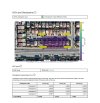
It works great with RTK and no points at all, and here is one I did with a minimum of 4 checkpoints.
 

Attachments

  • Screenshot 2023-02-04 154044.jpg
    Screenshot 2023-02-04 154044.jpg
    311.4 KB · Views: 7
  • Like
Reactions: jaja6009
I did test their elevation calibration tool and it does work pretty well. I made my map with ellipsoid elevations and then calibrated the elevation to a control point with orthometric height. Comparing it to the same output in Agisoft, it was within a cm in 15 different sample areas.
This has been my go-to way to get the state plane elevation with DD. It works well, but not perfectly. But have done work for licensed surveyors and had no issues
 
I will work on all of what you have provided, and Im thankful for the valuable information. Most of my work has been through DD and my workflow was to keep it in Global CS and calibrate elevation and export in NAD83 EPSG 6521
 
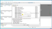
I think maybe cause Im on trial it will not load, attached
 

Attachments

  • Cant Load.jpg
    Cant Load.jpg
    189.8 KB · Views: 6
I'm with Dave Pitman on this. Keep it simple.

1. Average RS2 with NTRIP corrections in NAD83(2011) ellipsoid
2. Set Manual Base Mode on RS2 and use your averaged values. You are now outputting NAD83(2011) ellipsoid to your drone over Emlid Caster NTRIP.
3. Use RS+ to collect Control Points. Use Your State Plane and NAVD88 ft. Use them as your Check Points in DD.
4. Process your data. Mark your Control Points.
5. Use the elevation from a Check Point in the Drone Deploy Elevation Calibration Tool.

Done. You now have your elevations in orthometric.

I did this on a project and compared it to Agisoft using its geoid undulation grid and they agreed pretty well. Low centimeter to sub centimeter agreement in 15 random places I checked. And Drone Deploy should export your data with this shift in place.
 
  • Like
Reactions: jmason702
2. Set Manual Base Mode on RS2 and use your averaged values. You are now outputting NAD83(2011) ellipsoid to your drone over Emlid Caster NTRIP.
I am pretty positive you can skip this step in the workflow. Once the base is done averaging, it saves that point and sends it out through Emlid caster if you have it on
 
I'm with Dave Pitman on this. Keep it simple.

1. Average RS2 with NTRIP corrections in NAD83(2011) ellipsoid
2. Set Manual Base Mode on RS2 and use your averaged values. You are now outputting NAD83(2011) ellipsoid to your drone over Emlid Caster NTRIP.
3. Use RS+ to collect Control Points. Use Your State Plane and NAVD88 ft. Use them as your Check Points in DD.
4. Process your data. Mark your Control Points.
5. Use the elevation from a Check Point in the Drone Deploy Elevation Calibration Tool.

Done. You now have your elevations in orthometric.

I did this on a project and compared it to Agisoft using its geoid undulation grid and they agreed pretty well. Low centimeter to sub centimeter agreement in 15 random places I checked. And Drone Deploy should export your data with this shift in place.
I agree also it has always worked well. but I may be leaving DD, I want to buy a license and not have to pay for it every year. and I hate how DD charges me $50 every time I use checks or GCPs
 
I wanted to, I set up the Emlid app to do so.
Just an FYI. In Metashape, you can do all your processing within wgs84, or NAD83, etc., and then export the surface in State Plane, or another projected system, if that is your desired deliverable. It's not dependent on transforming coordinates in the field.
 
Just an FYI. In Metashape, you can do all your processing within wgs84, or NAD83, etc., and then export the surface in State Plane, or another projected system, if that is your desired deliverable. It's not dependent on transforming coordinates in the field.
Thanks, that does answer another one of my questions
 
Can Metashape produce a Thermal JPEG non-radiometric map? Just using thermal JPEGs 640 x 512
 
You having the demo version might be the reason you cannot update the geoid, we would have to check the Agisoft forum for the answer.

Agisoft can make RGB orthos using 640 rez thermal images.
Agisoft as of right now is not making a radiometric ortho with Autel Evo 2 640T, Mavic 2 EA, M3E or H20 Series as I still have not seen anyone figure out the formula in its Raster Transform. (This could be wrong as someone may have solved it by now.)

You have a tough choice to make. Drone Deploy does some things noone else does, has the best integrated sharing, has great tools for analysing shared data (The volume tool with the raised TIN is a favorite of anyone using it) and adds radiometric thermals orthos pretty quick when new thermal sensors come out. I am lucky to have access to it through my college.
Don't let Agisoft and Pix4D scare you with the Coordinates Systems, Geoids, Ellipsoids and such. If you get stuck, just post it and there are always people on here that can answer your questions.
Pix4D Mapper 2 years straight has a discount on Cyber Monday, 2021 it was $2500 perpetual, and 2022 it was $3500 perpetual. It lacks true local geoid support (Geoid18 and 12 etc.) but still works great. Again, I am lucky to have access to it through my college.

I don't want to influence you, you need to pick what works for your business best and only you know that.

My reason for Agisoft were:
Local Geoid Support
Pricing
Its Tiled models are very good and they export out of Agi directly in ESRI scene layer for easy sharing (Must have ESRI Arc Online account and credits to host it).
Its ability to choose your Coordinate systems/datums for Output, Camera and Control Points.
It does have cloud processing and sharing (Not as good as Drone Deploy).
A decent forum for help (Pix4D has the best Customer Support in my experience but you must pay the annual 15%? fee after perpetual purchase). The one lady figured out with a sample dataset that my Mavic 2 Enterprise Advanced uses ellipsoid for it Altitude in metadata. (Sharp Lady).
Proper weighting of RTK obtained images and Control Points. You import the confidence levels and Agi weights it in processing. I don't know what Drone Deploy is doing in the background.

Correaltor, Carlson and the other are all great software. It is a hard decision. I want them all.
 
I ran the same last mission through DD again, with 4 GCPs, not checks, DD must have updated their system, before with an RTK Drone and GCPs the data went off like crazy. I put in the state plane points and numbers are good with Geoid elevations.
 
  • Like
Reactions: jaja6009
I ran the same last mission through DD again, with 4 GCPs, not checks, DD must have updated their system, before with an RTK Drone and GCPs the data went off like crazy. I put in the state plane points and numbers are good with Geoid elevations.
Its strange you say that. I recently ran a dataset in DD with RTK images, checks and GCPs. It came out close to double digits RMSE while in Pix and Agi it was 1 to 2 cm RMSE.
I asked Customer Support on our $8000 a year plan, and never even received a response.

Don't forget you also have the Elevation Calibration Tool. I tried it, and it worked pretty good in a comparison with Agi's output.
 
My trial is running out on meta shape, is there a tool? like a marker, you can put on the map and it gives you your coords and elevation at that point?

I could not find one yesterday when working with it, I did reprocess an older map from the EVO and one from the M3E and got good results with points in NAD83 6521. If I could get that geoid 18 to work I think I would be good to go.

Just still debating, I tried Carlson, Sim Active, PIX, and others, (not a fan of PIX) but I think the best two are DD and Metashape.
I know you are very limited with data control in DD, but it works so well! and as you stated, the tools and sharing are like no other.
Also as you stated, I wish I could have them all, but not possible. I will keep working on it...
Thanks for all your help!
Use the Draw Shape dropdown. Choose Point. Place the point. Right click on the point. Measure.
 
  • Like
Reactions: Dave Pitman

Latest threads

Members online

No members online now.

Forum statistics

Threads
11,290
Messages
103,017
Members
9,900
Latest member
Barry.bain