Welcome, Autel Pilots!
Join our free Autel drone community today!
Join Us

Best Practices to Connect an Emlid Reach RS2 Base to an Autel Evo II Pro Enterprise RTK Drone

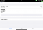
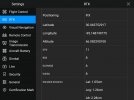
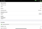
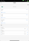
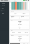
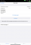
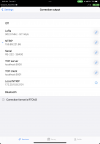
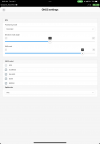
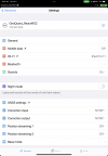
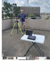
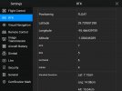
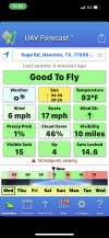
Attached is a series of screen captures showing before and after the battery change. RS2 was always receiving a FIX position before and after Autel drone battery change. Autel drone was receiving a FIX position before the battery change and FLOAT afterwards. I waited a long time and tried a number of trouble shooting steps but finally gave up on the Autel drone (Autel Explorer) receiving a FIX position.
 

Attachments

  • IMG_4178.PNG
    IMG_4178.PNG
    490.9 KB · Views: 7
  • 2022_05_19_11_04_40.jpg
    2022_05_19_11_04_40.jpg
    202.3 KB · Views: 7
  • 2022_05_19_11_24_00.jpg
    2022_05_19_11_24_00.jpg
    989.1 KB · Views: 7
  • IMG_4197.PNG
    IMG_4197.PNG
    299.8 KB · Views: 7
  • 2022_05_19_11_50_15.jpg
    2022_05_19_11_50_15.jpg
    206.8 KB · Views: 7
Have you tried walking the drone around when this happens? Ours floats for a while after the change and I walk 30ft out and back and see the deviation start to drop. If you see the sats drop from 25-30 to 10 out of the blue restart until it works. There's got to be something going on with the GNSS. I have seen it do this almost every flight. There's to many variables with connectivity issues to know for sure some times.
 
  • Like
Reactions: DanielD
Have you tried walking the drone around when this happens? Ours floats for a while after the change and I walk 30ft out and back and see the deviation start to drop. If you see the sats drop from 25-30 to 10 out of the blue restart until it works. There's got to be something going on with the GNSS. I have seen it do this almost every flight. There's to many variables with connectivity issues to know for sure some times.
Thanks. I will try this next time. I have picked up the drone off of the launch pad and brought it near the controller just to see if anything changes. No difference.
 
  • Like
Reactions: elphtrooper
Have you tried walking the drone around when this happens? Ours floats for a while after the change and I walk 30ft out and back and see the deviation start to drop. If you see the sats drop from 25-30 to 10 out of the blue restart until it works. There's got to be something going on with the GNSS. I have seen it do this almost every flight. There's to many variables with connectivity issues to know for sure some times.
I concur, after a battery change I was sitting in the grass waiting for a fix for 5 minutes. Then I picked up the UAS and walked 4 steps - boom, FIX.
 
  • Like
Reactions: elphtrooper
I am shooting a fairly complex survey tomorrow morning around a 20 story condo. It has been a while since I used the Emlid Reach RS2. I setup the equipment this morning in my driveway and captured a number of screen shots. I have two objectives with RTK, location accuracy and drone stability. Please review screen shots to see if my setup looks sound. Thanks so much!
 

Attachments

  • 37120D08-8CC3-416E-8220-2B500B190BAF.png
    37120D08-8CC3-416E-8220-2B500B190BAF.png
    409.5 KB · Views: 6
  • 0A7E56C3-A3C5-4915-A5F1-D36952D9A679.png
    0A7E56C3-A3C5-4915-A5F1-D36952D9A679.png
    736.5 KB · Views: 7
  • 572314BC-7CA2-48A2-AF22-36364F992EF3.png
    572314BC-7CA2-48A2-AF22-36364F992EF3.png
    777.6 KB · Views: 7
  • D178C58D-756F-4738-911C-FEF6A54C46E2.png
    D178C58D-756F-4738-911C-FEF6A54C46E2.png
    327.7 KB · Views: 7
  • 74B33BB3-71A0-42F3-B6B5-77D19C5994C7.png
    74B33BB3-71A0-42F3-B6B5-77D19C5994C7.png
    494.9 KB · Views: 7
  • 7F3C324A-9204-4634-B9F5-E3F93CFC0455.png
    7F3C324A-9204-4634-B9F5-E3F93CFC0455.png
    563.3 KB · Views: 6
  • 4CE697DE-8E4B-4BC6-9B9C-6153B3794BCF.png
    4CE697DE-8E4B-4BC6-9B9C-6153B3794BCF.png
    366.1 KB · Views: 4
  • C0333CED-0704-4C64-95F7-7E8C2E1EA553.png
    C0333CED-0704-4C64-95F7-7E8C2E1EA553.png
    547.4 KB · Views: 4
  • 141D8C8E-E757-4B17-823C-941A9D9274CC.png
    141D8C8E-E757-4B17-823C-941A9D9274CC.png
    557.4 KB · Views: 4
  • 8F7A90B0-C275-46DC-B000-C87C7AB49161.png
    8F7A90B0-C275-46DC-B000-C87C7AB49161.png
    327.5 KB · Views: 5
I am shooting a fairly complex survey tomorrow morning around a 20 story condo. It has been a while since I used the Emlid Reach RS2. I setup the equipment this morning in my driveway and captured a number of screen shots. I have two objectives with RTK, location accuracy and drone stability. Please review screen shots to see if my setup looks sound. Thanks so much!
On the base I would consider entering the known coordinate or that average fix point so that it stays static and can be trusted to be tight if you come back. Depending on where you are I would consider removing beidou and qzss. They're a 50/50 shot for us but we typically end up cutting them in PPK so why would I want to use them as part of the RTK fix...
 
  • Like
Reactions: Dave Pitman
On the base I would consider entering the known coordinate or that average fix point so that it stays static and can be trusted to be tight if you come back. Depending on where you are I would consider removing beidou and qzss. They're a 50/50 shot for us but we typically end up cutting them in PPK so why would I want to use them as part of the RTK fix...
Ok. I will plan to remove (uncheck) the beidou and qzss. I want to make sure I clearly understand your suggestion regarding the Base. I will not be over a known point such as a survey marker. I am simply connecting to the NTRIP network I subscribe to in order to get an RTK corrected fix over the spot where the RS2 is located. Are you suggesting that once I get a good FIX using average fix that I set Base mode settings to Manual and input the Position coordinates? Antenna height? Off or 2.134m?
 

Attachments

  • Base Mode Settings-3.jpg
    Base Mode Settings-3.jpg
    112.1 KB · Views: 0
  • Base Mode Settings-2.jpg
    Base Mode Settings-2.jpg
    119 KB · Views: 0
  • Base Mode Settings-1.jpg
    Base Mode Settings-1.jpg
    138.1 KB · Views: 0
position mode? Static if your not moving the base, if collecting GCPs then kinomatic
 
Also i set my ave fix to 10 min, set up base first then set everything else up. me personally I leave it as ave fix and not manual
after 10 min, it holds those coords
I know this because during those 10 min you will not get a fix on drone, until those 10 mins are done
 
  • Like
Reactions: Dave Pitman
Most surveyors I talk to say, to very accurately measure a point, its about 15 min set time
 
I agree! Other than removing (unchecking) the beidou and qzss satellites, I will continue to use average fix and let acquire but for 15 minutes. Attached is our typical setup. We will move the RS2 around to 3 different sides of the 16-17 story condo we are shooting.
 

Attachments

  • A5F690C1-3548-44E0-99E4-94AEEEBAD466.jpeg
    A5F690C1-3548-44E0-99E4-94AEEEBAD466.jpeg
    1.1 MB · Views: 6
Ok. I will plan to remove (uncheck) the beidou and qzss. I want to make sure I clearly understand your suggestion regarding the Base. I will not be over a known point such as a survey marker. I am simply connecting to the NTRIP network I subscribe to in order to get an RTK corrected fix over the spot where the RS2 is located. Are you suggesting that once I get a good FIX using average fix that I set Base mode settings to Manual and input the Position coordinates? Antenna height? Off or 2.134m?
You don't have to put it in manual but at least write the coordinate down or screenshot it so that if you come back you can go manual and input. The base height doesn't matter as long as you put the same value in you used for the first survey. We always enter our 2m regardless if it's a 2m rover rod or a 5.5ft permanent base pole.
 
  • Like
Reactions: Dave Pitman
Ok. I will plan to remove (uncheck) the beidou and qzss. I want to make sure I clearly understand your suggestion regarding the Base. I will not be over a known point such as a survey marker. I am simply connecting to the NTRIP network I subscribe to in order to get an RTK corrected fix over the spot where the RS2 is located. Are you suggesting that once I get a good FIX using average fix that I set Base mode settings to Manual and input the Position coordinates? Antenna height? Off or 2.134m?
The benefit of establishing a point via NTRIP and then using that point in manual, is that now your baseline to corrections is in meters and not kilometers. Baseline (lower) is king.

@elphtrooper s comment that if you establish a point, you can come back to it and verify the system is also a valid point.

Emlid has made recent changes to facilitate collecting a point (in a project) and then using that point as your coordinate in Manual base mode very easy.

Yes, in this scenario, set the antenna height both collecting the point and using the point in base mode.
 
Also i set my ave fix to 10 min, set up base first then set everything else up. me personally I leave it as ave fix and not manual
after 10 min, it holds those coords
I know this because during those 10 min you will not get a fix on drone, until those 10 mins are done
Your workflow is fine, Jeff. You are basically doing the same thing. The switch to Manual way just adds more options. Using the Local NTRIP feature is one, for example.
 
The screen capture shows 22 satellites visible to the Autel Evo 2 Enterprise RTK receiver. In this one area, I could not get from FLOAT to FIX. How many satellites does it take to get the Autel Evo 2 Enterprise drone into FIX positioning mode? Is it a magic number of satellites or the type of satellite (GPS, BDS, GLONASS, Galileo) that makes the difference? Other?
 

Attachments

  • 2022_07_06_11_54_40.jpg
    2022_07_06_11_54_40.jpg
    205.5 KB · Views: 3
  • IMG_2593.PNG
    IMG_2593.PNG
    899.6 KB · Views: 3
you have plenty of satellites, I'm not sure, I have had a FIX with just 12 and all the way up to 40 satellites
 

Latest threads

Members online

Forum statistics

Threads
11,292
Messages
103,023
Members
9,903
Latest member
Aerugo