- Joined
- May 9, 2021
- Messages
- 311
- Reaction score
- 153
- Age
- 69
- Location
- Kingwood, TX
- Website
- www.raptoraerialservices.com
Firmware is 28.4 . Says iRS2 is up to date.I am in Kingwood, TX. I will have to check the version of firmware.


Firmware is 28.4 . Says iRS2 is up to date.I am in Kingwood, TX. I will have to check the version of firmware.
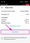
When selecting Average FIX for the Base mode I see no input for the antenna height. Only the Manual Base mode. Am I missing something?Firmware is 28.4 . Says iRS2 is up to date.
you're the MAN, enlight us, please...Whereabouts are you located? What Reach receiver firmware are you on?
When selecting Average FIX for the Base mode I see no input for the antenna height. Only the Manual Base mode. Am I missing something?

Ok. All makes sense! That is mostly how I started out. I will put this into a flowchart form and post for confirmation and comment. Thanks to all for responding and guiding me in the right direction.When using the RS2 to send corrections to the rover (drone) while occupying a known point, you want to use Manual Mode not Averaged, and enter the coordinates and the antenna height. So, if you are first establishing your known point via NTRIP, you would Average corrections for your given time, record the point, then switch the base mode to Manual, enter that recorded point's coordinates and antenna height, and then send corrections to the Evo via NTRIP/Emlid Caster. If I understand what you're up to correctly, that is !
I am in Kingwood, TX, about 25 miles NE of downtown Houston.you're the MAN, enlight us, please...
Okay, cool. I'm in Austin. If you're on 28.4 and it's not working correctly, then try 29.1. and if you're on 29.1 then vice versa and roll back to 28.4. there's two different issues that have been going on and they were both connectivity related.I am in Kingwood, TX. I will have to check the version of firmware.
This is the way.When using the RS2 to send corrections to the rover (drone) while occupying a known point, you want to use Manual Mode not Averaged, and enter the coordinates and the antenna height. So, if you are first establishing your known point via NTRIP, you would Average corrections for your given time, record the point, then switch the base mode to Manual, enter that recorded point's coordinates and antenna height, and then send corrections to the Evo via NTRIP/Emlid Caster. If I understand what you're up to correctly, that is !
Please review the attached workflow document and comment as necessary. Thanks.Ok. All makes sense! That is mostly how I started out. I will put this into a flowchart form and post for confirmation and comment. Thanks to all for responding and guiding me in the right direction.
Looks correct !Please review the attached workflow document and comment as necessary. Thanks.
Thanks Dave! I am still a little confused. My diagram is intended to use the antenna height (2.00m+0.134m = 2.134m) to move the known point height from the phase center of the antenna (Base Mode: Average FIX) directly to the ground beneath (Base Mode: Manual). I know when I use GCPs I am always using the height of the ground at each GCP location. I assume the RTK drone needs the height of the ground at the base station (RS2 receiver) location. I am new to RTK drones but not GCPs. Understanding the Base-Rover height setup has been somewhat challenging to understand.Basic Steps
In your flow chart for step 1, it looks good except that the position that the RS2 is displaying is the phase center of the antenna. Not the point on the ground. You are then using that coordinate for your Known Point. That is incorrect if you are then entering a pole length in the Manual point settings. You can probably just use the phase center coordinate in both, or you need to account for the pole length in the Manual point's settings.
- Establishing a Known Point
- Using the Known Point to broadcast corrections.
If you want to use the coordinate at the ground and not the phase center, then just open a project where you have entered a pole height and collect a point. Then you will have the coordinate at the ground (accounting for the pole length mentioned above) and not the phase center. You can verify that the collected point's elevation is the pole length lower than the coordinate that was displayed while receiving corrections.
Note, I'm using "pole length" to include the .134m which is added automatically by RV3 (total antenna height).
Hopefully this makes sense?
Thanks to all for being patient with me as I work through a good workflow.Thanks Dave! I am still a little confused. My diagram is intended to use the antenna height (2.00m+0.134m = 2.134m) to move the known point height from the phase center of the antenna (Base Mode: Average FIX) directly to the ground beneath (Base Mode: Manual). I know when I use GCPs I am always using the height of the ground at each GCP location. I assume the RTK drone needs the height of the ground at the base station (RS2 receiver) location. I am new to RTK drones but not GCPs. Understanding the Base-Rover height setup has been somewhat challenging to understand.
I think I may have been confusing so I edited my post. I think you are accounting for the pole height with the manual antenna height setting.Thanks Dave! I am still a little confused. My diagram is intended to use the antenna height (2.00m+0.134m = 2.134m) to move the known point height from the phase center of the antenna (Base Mode: Average FIX) directly to the ground beneath (Base Mode: Manual). I know when I use GCPs I am always using the height of the ground at each GCP location. I assume the RTK drone needs the height of the ground at the base station (RS2 receiver) location. I am new to RTK drones but not GCPs. Understanding the Base-Rover height setup has been somewhat challenging to understand.
Thanks Dave! Given your last statement, is the workflow I created correct? Will it give me the results I need to minimize the number of GCPs or even eliminate the need for GCPs at all? I would still survey in a couple of CPs.I think I may have been confusing so I edited my post. I think you are accounting for the pole height with the manual antenna height setting.
The difference between setting GCPs and using the RS2 as an NTRIP base is that the coordinate doesn't have to be on the ground unless you are also using that point as a GCP. In a base rover scheme, the base is simply sending corrections that it is calculating by determining variation from a known point. That known point could be the phase center, or the ground. It doesn't really matter. Now, if you were to set up on recorded known point, like a marker or monument, that coordinate is going to be the marker on the ground, obviously. But when you are just setting up and establishing a point on the fly via NTRIP, phase center is okay. But, it's probably better to stick to using the ground all the time in order to standardize your workflow.
If you are using the coordinate displayed in the Status Overview > Position (like in your chart) and enter that in your Base > Manual settings, you would not add an antenna height because that coordinate is not on the ground. It is the phase center. If you add an antenna height, you will get a bias in your corrections of that height. At least that is my understanding.Given your last statement, is the workflow I created correct?
Absolutely it will minimize the # of GCPs needed. I still use GCPs if accuracy is critical. They do tighten up a reconstruction to some degree. But I use a lot less. When you have the time on a project, set 7 points. Do 2 reconstructions. On one, use all 7 points as Checkpoints and see what the average error is. Then, process it again with 5 GCPs and 2 CPs and see what the average error is by comparison. You will get a feel for how much help it delivers and then you can make judgement calls based upon the demand of a particular project for what you need to do.Will it give me the results I need to minimize the number of GCPs or even eliminate the need for GCPs at all? I would still survey in a couple of CPs.
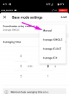
Is it correct to use Average FIX as the Base Mode on the RS2. Use Emlid Caster to pass RTK corrections between the RS2 receiver base and the Evo II RTK drone rover via NTRIP network? Once the drone survey is completed, process the drone image data as normal and convert from ellipsoid height to orth height?If you are using the coordinate displayed in the Status Overview > Position (like in your chart) and enter that in your Base > Manual settings, you would not add an antenna height because that coordinate is not on the ground. It is the phase center. If you add an antenna height, you will get a bias in your corrections of that height. At least that is my understanding.
If you have a marker on the ground that you know the coordinates of and set up your RS2 on that to send corrections rather than creating your own point via NTRIP like above, then you would enter the antenna height in the Base dialog because the published coordinate was measured at the ground.
I know it's confusing. But you just have to keep in mind that the gnss receiver is always telling you the coordinate at the phase center of the antenna. From there, you add an antenna height in circumstances where you want the coordinate to represent the spot on the ground, not the phase center.
Absolutely it will minimize the # of GCPs needed. I still use GCPs if accuracy is critical. They do tighten up a reconstruction to some degree. But I use a lot less. When you have the time on a project, set 7 points. Do 2 reconstructions. On one, use all 7 points as Checkpoints and see what the average error is. Then, process it again with 5 GCPs and 2 CPs and see what the average error is by comparison. You will get a feel for how much help it delivers and then you can make judgement calls based upon the demand of a particular project for what you need to do.
Michael (elphtrooper) says he doesn't usually use GCPs much. But he has lots of experience and in many cases he can just shift the entire surface in software to align it with some existing data if needed. I have provided data to earth works guys that just need a properly scaled surface and they can slide it around to align with drawings or whatever if needed.
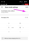
This is the setting to use when your RS2 is the Rover. It is a Rover when it is receiving corrections from an NTRIP Service.Is it correct to use Average FIX as the Base Mode on the RS2
After you have established your base coordinate (the step above) you then set the RS2 in Manual and specify the coordinate. Then you turn on send corrrections via Emlid Caster.Use Emlid Caster to pass RTK corrections between the RS2 receiver base and the Evo II RTK drone rover via NTRIP network?
Yes, if you need ortho height for your project.Once the drone survey is completed, process the drone image data as normal and convert from ellipsoid height to orth height?
Ok. Turn off antenna height (antenna height = 0)?This is the setting to use when your RS2 is the Rover. It is a Rover when it is receiving corrections from an NTRIP Service.
After you have established your base coordinate (the step above) you then set the RS2 in Manual and specify the coordinate. Then you turn on send corrrections via Emlid Caster.
Yes, if you need ortho height for your project.
I was just going to comment that I'm not sure if Reachview can have simultaneous connections to an NTRIP service and broadcast to Emlid Caster at the same time. I would guess no. But it seems to be working that way for you? I've posted that question over on the Emlid forum to see what they say and I'll relay what they say. Probably on Monday.On Average FIX, once the RS2 has calculated its position in base mode (receiving corrections from NTRIP). Then the RS2 has already found and holds that coords. Correct?
If so then why to switch to manual mode... just currous


We use essential cookies to make this site work, and optional cookies to enhance your experience.