

You are using an out of date browser. It may not display this or other websites correctly.
You should upgrade or use an alternative browser.
You should upgrade or use an alternative browser.
Best Practices to Connect an Emlid Reach RS2 Base to an Autel Evo II Pro Enterprise RTK Drone
- Thread starter Malli35998
- Start date


elphtrooper
Well-Known Member
- Joined
- May 6, 2022
- Messages
- 176
- Reaction score
- 111
- Age
- 50
Not yet. I'll hit it again tonight in hopes to get at least one project done tomorrow. If not I'll just keep doing what we're doing until we get there. Last thing I want to do is have to send it back.@elphtrooper you gotten your bird figured out yet?


elphtrooper
Well-Known Member
- Joined
- May 6, 2022
- Messages
- 176
- Reaction score
- 111
- Age
- 50
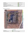
Looks pretty typical to me. Was this with RTK assist on in the bundle adjustment? I still never heard back from them from the sample data I ran before. Hadn't had a chance to run the new stuff but once I get the Evo working I'll have some more time.In the middle of this, does this look correct
yes, on this attachment it shows itLooks pretty typical to me. Was this with RTK assist on in the bundle adjustment? I still never heard back from them from the sample data I ran before. Hadn't had a chance to run the new stuff but once I get the Evo working I'll have some more time.
Attachments

- Joined
- May 9, 2021
- Messages
- 311
- Reaction score
- 153
- Age
- 69
- Location
- Kingwood, TX
- Website
- www.raptoraerialservices.com
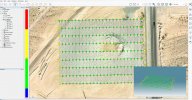
I put GCPs in Lat/Long/Altitude (m)/GCP ID.Sorry ......
- Joined
- May 9, 2021
- Messages
- 311
- Reaction score
- 153
- Age
- 69
- Location
- Kingwood, TX
- Website
- www.raptoraerialservices.com
No, how were they sent?you get the screenshots for rs2, hope that helps, but I'm pretty sure you were money all along
- Joined
- May 9, 2021
- Messages
- 311
- Reaction score
- 153
- Age
- 69
- Location
- Kingwood, TX
- Website
- www.raptoraerialservices.com
No, how did you send them?you get the screenshots for rs2, hope that helps, but I'm pretty sure you were money all along
- Joined
- May 9, 2021
- Messages
- 311
- Reaction score
- 153
- Age
- 69
- Location
- Kingwood, TX
- Website
- www.raptoraerialservices.com
Looks great! C3D does support CSV files. That is the way I load them. I generally load Lat/Long/Altitude (m)/GCP ID. Always has worked fine for me.It turned out beautiful in DD a while back, I can not get the GCPs to upload in simactive, looks as if they don't use CSV files. I converted it to a text file and it shows up but won't upload
- Joined
- May 9, 2021
- Messages
- 311
- Reaction score
- 153
- Age
- 69
- Location
- Kingwood, TX
- Website
- www.raptoraerialservices.com
I see them now. I missed them earlier. Your screen captures describe the way I setup the RS2. I have given SimActive a lot of feedback and data to review. I reprocessed the data with a single GCP (vs none). The Z values measured at known GCP locations were <0.5 ft to <1 ft different. I am not sure how well they handle RTK-Assisted data especially with no GCPs.No, how were they sent?
- Joined
- May 9, 2021
- Messages
- 311
- Reaction score
- 153
- Age
- 69
- Location
- Kingwood, TX
- Website
- www.raptoraerialservices.com

elphtrooper
Well-Known Member
- Joined
- May 6, 2022
- Messages
- 176
- Reaction score
- 111
- Age
- 50
The elevation is derived at the phase center and then the rod height is subtracted so the value is the surface. If you run a grid CRS with a Geoid then you will get orthometric elevations.Back to the Emlid Reach RS2. See attachment. It appears the elevation the RS2 is showing is the ellipsoid height of the receiver (before the antenna height (2.134m) is substracted) Correct?
- Joined
- May 9, 2021
- Messages
- 311
- Reaction score
- 153
- Age
- 69
- Location
- Kingwood, TX
- Website
- www.raptoraerialservices.com
It appears the rod height is not being subtracted so the value is the receiver height. This may be a setup issue. I independently measured the ellipsoidal height of the same base location with an EOS Arrow Gold GNSS RTK receiver. The ellipsoid height was -7.886m for the receiver. Substracting the 2.035m rod height results in a ellipsoid height of -9.928m for the surface. To me, using Average FIX, it is not obvious how the rod (antenna) height is being applied. I wish they made it clearer what the height measurement represents (receiver vs surface).The elevation is derived at the phase center and then the rod height is subtracted so the value is the surface. If you run a grid CRS with a Geoid then you will get orthometric elevations.
elphtrooper
Well-Known Member
- Joined
- May 6, 2022
- Messages
- 176
- Reaction score
- 111
- Age
- 50
Are you on the Emlid forum as well? I know I have seen this question before because it is pretty vague on how it technically works. I remember downloading and just noticing that the rod height showed 7ft when it is actually 6.56ft (2m) but there was a reason for it as backend data that didn't affect the orthometric values. I'm assuming you are using geodetic coordinates and ellipsoid heights for you analysis? It's not often I see negative HAE values. I don't know if this might get you on a track that helps.It appears the rod height is not being subtracted so the value is the receiver height. This may be a setup issue. I independently measured the ellipsoidal height of the same base location with an EOS Arrow Gold GNSS RTK receiver. The ellipsoid height was -7.886m for the receiver. Substracting the 2.035m rod height results in a ellipsoid height of -9.928m for the surface. To me, using Average FIX, it is not obvious how the rod (antenna) height is being applied. I wish they made it clearer what the height measurement represents (receiver vs surface).
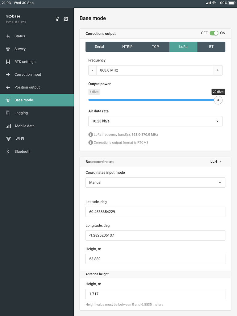
Base Antenna Height
We were collecting ground control points yesterday with our base placed over a known point. As usual we entered the manual coordinates, but in the past I have always added the antenna height to the height field in the LLH entry. This time I used the actual mark height and added the antenna...
 community.emlid.com
- Joined
- May 9, 2021
- Messages
- 311
- Reaction score
- 153
- Age
- 69
- Location
- Kingwood, TX
- Website
- www.raptoraerialservices.com
I ultimately use ortho heights. I am using a base-rover configuration with the rover being a drone. Both the base (RS2) and the drone (Autel Evo 2 RTK) use ellipsoid height. My primary focus has been getting the RS2 setup correctly so that I can record RTK corrected positions. I convert the drone surveys to ortho height using photogrammetry processing software using a minimal number of GCPs.Are you on the Emlid forum as well? I know I have seen this question before because it is pretty vague on how it technically works. I remember downloading and just noticing that the rod height showed 7ft when it is actually 6.56ft (2m) but there was a reason for it as backend data that didn't affect the orthometric values. I'm assuming you are using geodetic coordinates and ellipsoid heights for you analysis? It's not often I see negative HAE values. I don't know if this might get you on a track that helps.
Base Antenna Height
We were collecting ground control points yesterday with our base placed over a known point. As usual we entered the manual coordinates, but in the past I have always added the antenna height to the height field in the LLH entry. This time I used the actual mark height and added the antenna...
elphtrooper
Well-Known Member
- Joined
- May 6, 2022
- Messages
- 176
- Reaction score
- 111
- Age
- 50
All drones use geodetic (geographic) coordinate systems. In the US you can plug in WGS84/NAD38 and the photogrammetry software exports to grid. We don't use GCP's anymore. On an average site we have gone from 20 GCP's to 4 checkpoints. We average the error across the board and end up with a calculation sheet for backup. DroneDeploy's elevation calibration gets it to ortho and away we go. Are you using the Emlid local NTRIP?I ultimately use ortho heights. I am using a base-rover configuration with the rover being a drone. Both the base (RS2) and the drone (Autel Evo 2 RTK) use ellipsoid height. My primary focus has been getting the RS2 setup correctly so that I can record RTK corrected positions. I convert the drone surveys to ortho height using photogrammetry processing software using a minimal number of GCPs.
- Joined
- May 9, 2021
- Messages
- 311
- Reaction score
- 153
- Age
- 69
- Location
- Kingwood, TX
- Website
- www.raptoraerialservices.com
I am not quite to the point of eliminating GCPs. I want to get to 4 GCPs and 2 CPs. Yes, I use an RTK correction service and Emlid Caster NTRIP for both the RS2 and RTK drone. My biggest issue, besides getting the RS2 to easily and quickly connect to an iOS mobile hotspot, is getting the height/altitude values correct.All drones use geodetic (geographic) coordinate systems. In the US you can plug in WGS84/NAD38 and the photogrammetry software exports to grid. We don't use GCP's anymore. On an average site we have gone from 20 GCP's to 4 checkpoints. We average the error across the board and end up with a calculation sheet for backup. DroneDeploy's elevation calibration gets it to ortho and away we go. Are you using the Emlid local NTRIP?
elphtrooper
Well-Known Member
- Joined
- May 6, 2022
- Messages
- 176
- Reaction score
- 111
- Age
- 50
Whereabouts are you located? What Reach receiver firmware are you on?I am not quite to the point of eliminating GCPs. I want to get to 4 GCPs and 2 CPs. Yes, I use an RTK correction service and Emlid Caster NTRIP for both the RS2 and RTK drone. My biggest issue, besides getting the RS2 to easily and quickly connect to an iOS mobile hotspot, is getting the height/altitude values correct.
- Joined
- May 9, 2021
- Messages
- 311
- Reaction score
- 153
- Age
- 69
- Location
- Kingwood, TX
- Website
- www.raptoraerialservices.com
I am in Kingwood, TX. I will have to check the version of firmware.Whereabouts are you located? What Reach receiver firmware are you on?
Similar threads
- Replies
- 0
- Views
- 669
- Replies
- 4
- Views
- 941
- Replies
- 4
- Views
- 2K
- Replies
- 3
- Views
- 1K


Latest threads
-
-
-
-
Seeking Recommendations for Custom Voiceover Solutions
- Started by nobes
- Replies: 1
-
We need your Autel evo 2 V1 6K rugged bundle.
- Started by Autel-euducational
- Replies: 1