

You are using an out of date browser. It may not display this or other websites correctly.
You should upgrade or use an alternative browser.
You should upgrade or use an alternative browser.
REALITY CAPTURE 1.2 THREAD
- Thread starter jmason702
- Start date
did you have a chance to process it? no problem if your busy broI will process in Pix4D, but it won't be until later tonight. I have to process 4 maps for work.
Dave Pitman
Well-Known Member
Not sure what's the problem but I cannot download. I either get only 110 images or it does not download at all.did you have a chance to process it? no problem if your busy bro
on Reality? no, not yet, need to try again...Were you able to get past the display issues?

I got the files, I did not notice that Google in its infinite wisdom would not let me download multiple zipped folders unless I checked a small popup. Processing now.on Reality? no, not yet, need to try again...
I will play around with it.
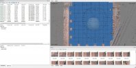
First one is with the Control Point as a Checkpoint
Pix4D
Images input as WGS84 with Ellipsoid Elevations
Check Point entered as WGS84 Ellipsoid elevations
Output in WGS84 UTM 11N


I got the horizontal shift that I also get on my PPK kit if Ground Control Points are not used. Part of this may be my confusion on the target. It's a painted X on the ground right?
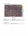
Images input as WGS84 with Ellipsoid Elevations
Check Point entered as WGS84 Ellipsoid elevations
Output in WGS84 UTM 11N
I got the horizontal shift that I also get on my PPK kit if Ground Control Points are not used. Part of this may be my confusion on the target. It's a painted X on the ground right?
Dave Pitman
Well-Known Member

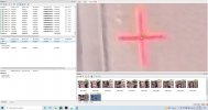
yes a orange XPix4D
Images input as WGS84 with Ellipsoid Elevations
Check Point entered as WGS84 Ellipsoid elevations
Output in WGS84 UTM 11N
View attachment 12357
View attachment 12358
View attachment 12359
View attachment 12360
View attachment 12361
I got the horizontal shift that I also get on my PPK kit if Ground Control Points are not used. Part of this may be my confusion on the target. It's a painted X on the ground right?

something is definitely not correct here...
190 ft AGL, 75/75 overlap, 11 MPH, manual, shutter 1250, 50 acres, over 700 photos, 1 point. Anyone let me know if you'd like the file to process?

DD report in feet. .72inch error VS MS at .82inch camera error
Attachments
I'll be back to help out maybe tomorrow. My computer is straining processing a 3800 image map that I promised someone.I will try Reality C. later, see if I can get a report off that
I have some questions on how you are going to transform into NAD83(2011) in the future, especially the NAVD88 elevations since that seems what you were doing before with GCPs.
I am really thinking about getting the Evo 2 Enterprise, as I like the images, battery life and pretty much all in one package from OEM.
Also with Reality Capture I think the display issues are due to just displaying. I got them all the time also when processing large datasets. On their online manual it explains it better.
The EVO 2 RTK or Enterprize seems to be the drone to get as far as really... everything to do with mapping and photo qualityI'll be back to help out maybe tomorrow. My computer is straining processing a 3800 image map that I promised someone.
I have some questions on how you are going to transform into NAD83(2011) in the future, especially the NAVD88 elevations since that seems what you were doing before with GCPs.
I am really thinking about getting the Evo 2 Enterprise, as I like the images, battery life and pretty much all in one package from OEM.
Also with Reality Capture I think the display issues are due to just displaying. I got them all the time also when processing large datasets. On their online manual it explains it better.
Similar threads
- Replies
- 2
- Views
- 1K


Latest threads
-
-
-
Seeking Recommendations for Custom Voiceover Solutions
- Started by nobes
- Replies: 1
-
We need your Autel evo 2 V1 6K rugged bundle.
- Started by Autel-euducational
- Replies: 1
-
Questions on original Evo 1 and the new app Autel Sky
- Started by jaja6009
- Replies: 0