I downloaded the pay-per-use version of this software, I am very surprised by how detailed and the dynamics of all that you can do. I have been looking at this for prolly 3 to 4 hours total and I can say there is a lot to it!!!
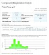
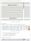
The great thing is you can produce your map model change or do anything to check the accuracy and so on, you only pay when you export something. Therefore it costs nothing to play with it and learn it. no trials...
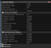
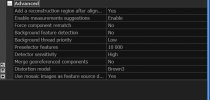
Secondly, I would have to say so far that there is a lot to figure out if you're into all the advanced tuning of the software, or you can push a button and it will do it all for you. But with the RTK drones, there is so much tweaking you can do, my head hurts after another 2 hours of looking at it.
Bonus--- it seems pretty cheap to export whatever you want. like a 1000 photo mission with ortho, DTMs, model, etc.. is like 20$, but you pay for nothing until you are done and happy with it.
From what I read, a gaming whale bought them out, added very advanced features, and completely changed the pricing system.
I want to start this thread for everyone interested in using this software (it's free to process and just advanced as Metashape or even more) You don't pay anything until you export and it's not very much. WAY better than paying 3500$ a year.
All users can post here on how they are setting up the software for an RTK drone or even a non-RTK drone, it appears to have a pretty high learning curve for advanced users.
I can tell this is going to be BIG!
Please share all experiences with the software here good or bad, so all that want to learn it can and we all can learn from each other.
Thanks
The great thing is you can produce your map model change or do anything to check the accuracy and so on, you only pay when you export something. Therefore it costs nothing to play with it and learn it. no trials...
Secondly, I would have to say so far that there is a lot to figure out if you're into all the advanced tuning of the software, or you can push a button and it will do it all for you. But with the RTK drones, there is so much tweaking you can do, my head hurts after another 2 hours of looking at it.
Bonus--- it seems pretty cheap to export whatever you want. like a 1000 photo mission with ortho, DTMs, model, etc.. is like 20$, but you pay for nothing until you are done and happy with it.
From what I read, a gaming whale bought them out, added very advanced features, and completely changed the pricing system.
I want to start this thread for everyone interested in using this software (it's free to process and just advanced as Metashape or even more) You don't pay anything until you export and it's not very much. WAY better than paying 3500$ a year.
All users can post here on how they are setting up the software for an RTK drone or even a non-RTK drone, it appears to have a pretty high learning curve for advanced users.
I can tell this is going to be BIG!
Please share all experiences with the software here good or bad, so all that want to learn it can and we all can learn from each other.
Thanks