Welcome, Autel Pilots!
Join our free Autel drone community today!
Join Us

Orthomosaic Maps and Arc Gis Pro

wes0007

New Member
Joined
Jul 21, 2021
Messages
1
Reaction score
0
Age
34
Hello, I'm new to the thread, Drones and Autel.... but I have experience using Arc Pro. I have done a few test flights and am preparing for a test creating a Orthomosaic Map using the Autel Explorer Missions. I have seen alot about Pics4D but am a student and short of asking my professor/college to buy it for the department am looking at using Arc Pro because it is already available to me. The only issue is that for the Ortho Mapping workspace in Arc Pro Autel is not listed as one of the Makers meaning I will have to input camera settings myself. I am able to get just about all the settings I need from the image properties window however I am at a loss for finding the "Pixel Size on the Sensor (in mm)". Does anyone know what that would be, where I could find it or how I can calculate that? Does anyone have experience using Arc Pro with a Autel drone? or Mapping with Autel in general. I'm open to advice and suggestions in general.
Below is a picture of the Camera Settings I need for Arc Pro. I can get Focal length, columns and rows from the properties window. The principal point and below are not required.
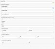

Arc Pro Settings.JPG
 
Hello, I'm new to the thread, Drones and Autel.... but I have experience using Arc Pro. I have done a few test flights and am preparing for a test creating a Orthomosaic Map using the Autel Explorer Missions. I have seen alot about Pics4D but am a student and short of asking my professor/college to buy it for the department am looking at using Arc Pro because it is already available to me. The only issue is that for the Ortho Mapping workspace in Arc Pro Autel is not listed as one of the Makers meaning I will have to input camera settings myself. I am able to get just about all the settings I need from the image properties window however I am at a loss for finding the "Pixel Size on the Sensor (in mm)". Does anyone know what that would be, where I could find it or how I can calculate that? Does anyone have experience using Arc Pro with a Autel drone? or Mapping with Autel in general. I'm open to advice and suggestions in general.
Below is a picture of the Camera Settings I need for Arc Pro. I can get Focal length, columns and rows from the properties window. The principal point and below are not required.


View attachment 11092
Great question. I haven't tried out an Autel Explorer mission in Pro yet...and will explore this for my own purposes as well. I would be inclined to set up Pro 'as if' you had used a different camera, see what value it puts in that PixelSize on the sensor', and then see if you can figure out what value to use for the Evo II (?) camera instead. Depending on how large your mission is, I might have a couple other options to suggest if you'd like to correspond with me directly: [email protected]...
 
I am needing those exact same answers for using Maps Made Easy to help calculate number of photos and dataset size. I found this information about the 1" sensor but it would be better if Autel would publish this information. They did list the settings for several DJI drones but none with the same setup as the EVO 2 Pro.

 
I can say I'm pretty familiar with mapping with the Evo 2 pro.

I'm an ArcGIS user, but use ESRI Sitescan to handle the processing of maps.
I cant give those exact values, but I can tell you what parameters Sitescan sets while processing from an Evo 2.

SiteScan has the camera listed as an XT705_10.6_5472x3648 (RGB)
the sensor dimensions are listed as 13.133mm x 8.755mm
Focal length is 10.570mm
Principal point x is 6.566mm
and Principal point y is 4.378mm

SiteScan produces some stellar results with the Evo2. Can't recommend it enough.
Would you be able to tRay a brief experiment for me? I am very curious if I can fly an autel UAV in the sitescan inspection mode? I dont currently have an autel to try this but am very curious since you are still manually flying the UAV in inspection mode. I am trying to open more options to myself besides DJI which I have been using for years. I realize that autel isn’t listed as supported by sitescan which I imagine just means the automated flying in the app for map creating but thought it may work in hte inspection tab of the sitescan app but have no way to verify besides taking a leap. Any info would be greatly appreciated. Thanks.
 

Latest threads

Members online

No members online now.

Forum statistics

Threads
11,280
Messages
102,952
Members
9,878
Latest member
Elio-Italy