Hello, I'm new to the thread, Drones and Autel.... but I have experience using Arc Pro. I have done a few test flights and am preparing for a test creating a Orthomosaic Map using the Autel Explorer Missions. I have seen alot about Pics4D but am a student and short of asking my professor/college to buy it for the department am looking at using Arc Pro because it is already available to me. The only issue is that for the Ortho Mapping workspace in Arc Pro Autel is not listed as one of the Makers meaning I will have to input camera settings myself. I am able to get just about all the settings I need from the image properties window however I am at a loss for finding the "Pixel Size on the Sensor (in mm)". Does anyone know what that would be, where I could find it or how I can calculate that? Does anyone have experience using Arc Pro with a Autel drone? or Mapping with Autel in general. I'm open to advice and suggestions in general.
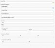
Below is a picture of the Camera Settings I need for Arc Pro. I can get Focal length, columns and rows from the properties window. The principal point and below are not required.

Below is a picture of the Camera Settings I need for Arc Pro. I can get Focal length, columns and rows from the properties window. The principal point and below are not required.


