

You are using an out of date browser. It may not display this or other websites correctly.
You should upgrade or use an alternative browser.
You should upgrade or use an alternative browser.
KML file
- Thread starter jmason702
- Start date
Dave Pitman
Well-Known Member
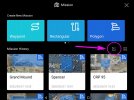
I'll have to look when I get homeOn the Mission page, do you have the import icon in the screenshot?
Dave Pitman
Well-Known Member

Detritalgeo
Well-Known Member
Dave Pitman
Well-Known Member
Thank you very much, Bro!fix is in the email
open the KML file in google earth and use the polygon tool and retrace it, save it as a KML file, and export it to your PC then to the SD card.
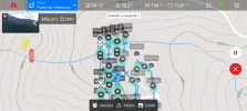
Then the Explorer app will open it as a Polly mission vs a waypoint mission
Then the Explorer app will open it as a Polly mission vs a waypoint mission
I’m able to upload Latitude, Longitude and Altitude. When I go into making alterations the “gimbal position” is not available. Is there a specific way that the Google Earth Pro needs to identify that setting in order for it to register in the upload?
Hola como estas soy de colombia he podido utilizar la mision tipo lineal para realizar vuelos con seguimiento de terreno utilizando la capacidad AGL y MSL de este tipo de mision. Esto solo es posible usando UgCS, pero la licencia es costosa, pero encontré una manera gratuita de hacerlo si te interesa contactarme. [email protected]
Attachments
How did you find the files? When i click the open button it just says "File placement path: mobile phone storage/android/data/com/autelrobotics.explorer/files/kmlscreen shot, thanks
Use the QGC is free, you just have to configure the camera, if you look at the previous message I have tried it successfully.is there any other way to utilize the terrain follow other than UGCS? This cost 150 USD / Month, that's a bit much for my taste
Similar threads
- Replies
- 3
- Views
- 631
- Replies
- 2
- Views
- 2K
- Replies
- 5
- Views
- 995
- Replies
- 2
- Views
- 1K


Latest threads
-
-
-
-
Seeking Recommendations for Custom Voiceover Solutions
- Started by nobes
- Replies: 1
-
We need your Autel evo 2 V1 6K rugged bundle.
- Started by Autel-euducational
- Replies: 1