Use the QGC is free, you just have to configure the camera, if you look at the previous message I have tried it successfully.


You are using an out of date browser. It may not display this or other websites correctly.
You should upgrade or use an alternative browser.
You should upgrade or use an alternative browser.
KML file
- Thread starter jmason702
- Start date
I am having the same problem. I can't copy the kml file from USB/SD card onto the requested locationHow did you find the files? When i click the open button it just says "File placement path: mobile phone storage/android/data/com/autelrobotics.explorer/files/kml
"File placement path: mobile phone storage/android/data/com/autelrobotics.explorer/files/kml
DanielD
Well-Known Member
- Joined
- May 16, 2022
- Messages
- 55
- Reaction score
- 16
had the same issue. The solution was just to open the kml directly and I was asked which program to open with -- > choose Autel Explorer. DoneI am having the same problem. I can't copy the kml file from USB/SD card onto the requested location

Detritalgeo
Well-Known Member
Before Ken left he said they were working on adding this to the Explorer App... who knows if they bailed on this or if it will only work with the Evo Max when ready...is there any other way to utilize the terrain follow other than UGCS? This cost 150 USD / Month, that's a bit much for my taste
DanielD
Well-Known Member
- Joined
- May 16, 2022
- Messages
- 55
- Reaction score
- 16
official statement from Autel, dated 20.03.2023:Before Ken left he said they were working on adding this to the Explorer App... who knows if they bailed on this or if it will only work with the Evo Max when ready...
"Unfortunately, our aircrafts do not have Terrain/altitude awareness. My apologies for any inconvenience this causes you. "

DanielD
Well-Known Member
- Joined
- May 16, 2022
- Messages
- 55
- Reaction score
- 16
I've configured the camera, thanks.Use the QGC is free, you just have to configure the camera, if you look at the previous message I have tried it successfully.
EDIT: how to configure the height correctly for the Autel explorer app? Google earth shows AGL correctly, the Autel explorer app shows ground level + MSL.
Last edited:
DanielD
Well-Known Member
- Joined
- May 16, 2022
- Messages
- 55
- Reaction score
- 16
Now we can do terrain following as well.
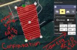
If you import your kml file, press on edit, then you can choose between AGL and MSL. Be sure to check the waypoint heights, since the Autel Explorer app adds 3 additional waypoints with "0" height to the mission.
If you import your kml file, press on edit, then you can choose between AGL and MSL. Be sure to check the waypoint heights, since the Autel Explorer app adds 3 additional waypoints with "0" height to the mission.
DanielD
Well-Known Member
- Joined
- May 16, 2022
- Messages
- 55
- Reaction score
- 16
still me, I did a thing:
GitHub - danieldobosi/jubilant-system
this script replaces the AMSL heights created in QGC with AGL. Feel free to test / comment / commit / change
GitHub - danieldobosi/jubilant-system
this script replaces the AMSL heights created in QGC with AGL. Feel free to test / comment / commit / change
Voy a realizar un vídeo con todos los pasos haciendo el Plan de vuelo con reconocimiento del terreno usando QGC y Google Earth Pro (GEP) (editar KML). cuando lo realice subo el enlace link. Tu solución con python es interesante,Todavía yo, hice una cosa:
GitHub - danieldobosi/jubilant-system
este script reemplaza las alturas AMSL creadas en QGC con AGL. Siéntase libre de probar/comentar/comprometer/cambiar
Attachments

Last edited:
Si puedes hacer video con este método seria interesanteTodavía yo, hice una cosa:
GitHub - danieldobosi/jubilant-system
este script reemplaza las alturas AMSL creadas en QGC con AGL. Siéntase libre de probar/comentar/comprometer/cambiar
Great solution. Thanks a bunch! I haven't flown using this method yet but a quick question (assuming you're importing the QGC KML to Autel Explorer as waypoints) there are turquoise triangle symbols that seem to indicate where photos are taken, but not at the waypoint themselves. When loaded, the mission reports zero photos will be taken in the upper right corner, when flown, are photos taken or not?still me, I did a thing:
GitHub - danieldobosi/jubilant-system
this script replaces the AMSL heights created in QGC with AGL. Feel free to test / comment / commit / change
Attachments
DanielD
Well-Known Member
- Joined
- May 16, 2022
- Messages
- 55
- Reaction score
- 16
Great question! Like I've mentioned above, I didn't have the opportunity to actually test it in a flight. I've imported a kml and that's it.Great solution. Thanks a bunch! I haven't flown using this method yet but a quick question (assuming you're importing the QGC KML to Autel Explorer as waypoints) there are turquoise triangle symbols that seem to indicate where photos are taken, but not at the waypoint themselves. When loaded, the mission reports zero photos will be taken in the upper right corner, when flown, are photos taken or not?
Did I understand correcty, you actually tested it and the mission completed with no pictures taken?
I attach a link with a video with the workflow from QGC, later to Google Earth Pro and finally to Autel explorer, this is verified. I don't speak English I hope you understand me.
 drive.google.com
QGC Follow Terrain Autel Evo 2 Pro V1 V2 V3.mp4
drive.google.com
mauricioranzan
Member
- Joined
- Aug 20, 2022
- Messages
- 9
- Reaction score
- 2
- Age
- 36
Which camera setup should I use for my Autel EVO II RTK V3 in QGC?Use the QGC is free, you just have to configure the camera, if you look at the previous message I have tried it successfully.
Todos los modelos Autel Evo II PRO y RTK tienen el mismo sensor por lo tanto la configuración seria la misma previamente descrita.Which camera setup should I use for my Autel EVO II RTK V3 in QGC?
All Autel Evo II PRO and RTK models have the same sensor, therefore the configuration would be the same as previously described.
Attachments
¿Podrías enviarme a mí también? Hice una misión con agisoft, quiero importar en un Autel evo 2 v3, but when I try to open always says Path Error.la solución está en el correo electrónico

¿Cuál fue la solución?
I thought I would do a quick update as I've been using Porites planning/mapping workflow extensively for the past few weeks. Whilst not perfect, this is by far the best solution for photogrammetry (with MetaShape) I've found so far. Thank you Porites! It produces decent 3D models, but I have yet to perfect the camera setup to get overly sharpened images (suggestions welcome).
I've also been using my own workflow for the EVO 2 Dual for thermal imagery (save in jpeg, I can't seem to get .irg images) utilizing ImageJ and the ThermImageJ plugin - GitHub - gtatters/ThermImageJ: ImageJ functions and macros for working with thermal image files -
1. Converting IRX. jpegs to tif via the TherImageJ Raw2Temp tool
2. spot checking values to temps in the viewer (i.e. 25436 = 31oC, 27342 = 37oC, etc x 200+)
3. running a linear regression between these values (in R)
4. using the resulting linear regression equation to convert 5-digit temp values in a processed Orthomosiac to degrees centigrade in QGIS.
This basically gets me everything I want out of using the Autel for photogrammetry EXCEPT the use of the RTK module with an Emlid RS+ as a base station without an internet connection. Anybody have any pointers for this? I asked Autel and the response was "Regarding GPS data set corrections, an active internet connection is not necessary, though collecting the data through RTK is the most reliable, and it is the option that is easier to obtain support with. Alternatively, you can use PPK (Post-Processing Kinematic) but with a base station system with an Android APK app that you can install and run on the Smart Controller. " Which is not quite an explanation yet.
Thanks!
Dave Pitman
Well-Known Member
Unfortunately, the RS+ is a single frequency transceiver a the Evo RTK uses a dual freq. They are not compatible. You need a dual freq. gnss like the RS2+. The Evo receives RTK corrections over NTRIP. The RS2+ can act as a base and send corrections to the Evo over NTRIP when all of the devices are near each other and you connect them all to a hot spot. I do this all the time. The Evo can also receive NTRIP corrections from a CORs network if it is available to you.
@jmason702ok i figure it out, but when I open the KML, it goes into a waypoint mission...
Hi! I am having trouble getting my kml files onto the Autel RCPad tablet controller for our Evo II Pro v3 RTK.
I did find the mission import button on the Mission screen, but it only looks in the directory:
/Android/data/com.autelrobotics.explorer/files/kml
The trouble is, I can only copy from my USB thumb drive to the Downloads folder on the RCPad, so it never sees it.
You said in June 2022 that you had figured it out. What did you do?
")
cheeseman
Active Member
- Joined
- Sep 9, 2023
- Messages
- 40
- Reaction score
- 13
- Age
- 37
You can open the KML file by clicking on it in files and it will open with autel explorer then you can save it into your missions.@jmason702
Hi! I am having trouble getting my kml files onto the Autel RCPad tablet controller for our Evo II Pro v3 RTK.
I did find the mission import button on the Mission screen, but it only looks in the directory:
/Android/data/com.autelrobotics.explorer/files/kml
The trouble is, I can only copy from my USB thumb drive to the Downloads folder on the RCPad, so it never sees it.
You said in June 2022 that you had figured it out. What did you do?
Alternately you can connect The smart controller to the PC over USB and transfer the file directly into the directory for explorer.
Similar threads
- Replies
- 3
- Views
- 618
- Replies
- 2
- Views
- 2K
- Replies
- 5
- Views
- 992
- Replies
- 2
- Views
- 1K


Latest threads
-
-
-
Seeking Recommendations for Custom Voiceover Solutions
- Started by nobes
- Replies: 1
-
We need your Autel evo 2 V1 6K rugged bundle.
- Started by Autel-euducational
- Replies: 1
-
Questions on original Evo 1 and the new app Autel Sky
- Started by jaja6009
- Replies: 0