This would be great!converting 640t files to Flir readable r.jpeg.


This would be great!converting 640t files to Flir readable r.jpeg.
Greetings! I am a late-comer to this thread. We are looking at the Autel EVO II 640T or R to get into thermal and visual inspections of buildings in the EU (we mostly work with lidar and multispectral imagery) which has become important considering our expensive energy costs! We are undecided on what system to get so this is an interesting post for us. I took a look at the dataset you posted and using Pix4D was able to produce an orthomosaic with the rectangle RGB data (looked really good). However, while the RGB data produced a good orthomosaic X/Y aligned with other imagery sources (using Global Mapper to compare results), the thermal orthomosaic was in a smaller scale and not aligned with either the RGB ortho we produced or the "control" data we used. I also checked the pointclouds Pix4D generated for both datasets and compared them to Aster GDEM V3 and found large misalignments in Z. Nevertheless, our goal is to buy a thermal drone that allows us to generate aligned RGB and Thermal orthomosaics...can this be done with the 640R (I see you need a converter for the 640T datasets and would prefer to avoid that). Of course, we also have a huge learning curve!This morning I flew created a simple waypoint survey and a polygon survey. The data from the one of the waypoints can be accessed via the Dropbox link below. I am using the latest Explorer App on Smart Controller (1.0.77.1) and Firmware (V.2.3.8) on my Evo II Enterprise drone with the Dual FLIR 640R camera. Please keep in mind that this is my first attempt with a thermal camera.
Dropbox
www.dropbox.com
Comments:
1. The simple Waypoint survey I designed did not fly as designed in the Autel Explorer app. The first waypoint I had the drone go up to 394' AGL and take 10 photos rotating 16 deg from a compass heading of 290 deg to 70 deg. Waypoint #2 was the same but at 300' AGL. Waypoints #3 and #4 were a short distance away and a repeat of Waypoints #1 and #2. The drone did some strange things but did manage to take 24 thermal photos. I also included both thermal and rgb images from the Rectangular Survey. Please keep in mind that I switched between thermal and rgb in the Autel Explorer app. Not complete coverage of both thermal and rgb images. Posted to Dropbox.
2. I had pre-programmed mission saved as a Polygon Survey created from an imported KML polygon. Each time I got a Mission upload failed. I tried modifying the existing polygon survey and even creating a new polygon survey. The same results each time. I created a simple rectangular survey and everything seemed to be fine. See screen captures.
3. I thought that having a Dual 640R that I would be able to capture both thermal IR and RGB photos of the same spot. Unless I am doing something wrong, this does not appear to be the case. You have to select (make active) rgb or ir thermal resulting in one of the other not both. If this is the case, I am very disappointed. As I switched (made active) between thermal and rgb in the Explorer App, I ended up with a survey with a mix of thermal IR images and RGB images but not of the same spot. I included screen captures of what files were stored on the SD Card.
4. Regarding radiometric data. I am a bit confused about what temperature information is being saved with these thermal images. I know these are JPEG format. In one of the screen captures you can see that the dark blue area was about 86 deg F. When I look at these images in FLIR Tools and hit Auto, they should a much lower temperature range. Does this require R.JPEG (Radiometric JPEG) in order to expose temperature data in each pixel?
Please take a look at what I posted. Please feel free to comment and/or ask any questions.
I am not an expert at thermal orthomosaics. Also, I don't use Pix4D. I use SimActive's Correlator3D to process the data. The sample thermal data I provided is off slightly in the XY direction vs the rgb orthomosaic but it is pretty close. Since this is a dual rgb/thermal IR camera, I am not sure how important the Z value is for the thermal orthomosaic. An accurate DSM/DTM can be generated from the rgb visible imagery.Greetings! I am a late-comer to this thread. We are looking at the Autel EVO II 640T or R to get into thermal and visual inspections of buildings in the EU (we mostly work with lidar and multispectral imagery) which has become important considering our expensive energy costs! We are undecided on what system to get so this is an interesting post for us. I took a look at the dataset you posted and using Pix4D was able to produce an orthomosaic with the rectangle RGB data (looked really good). However, while the RGB data produced a good orthomosaic X/Y aligned with other imagery sources (using Global Mapper to compare results), the thermal orthomosaic was in a smaller scale and not aligned with either the RGB ortho we produced or the "control" data we used. I also checked the pointclouds Pix4D generated for both datasets and compared them to Aster GDEM V3 and found large misalignments in Z. Nevertheless, our goal is to buy a thermal drone that allows us to generate aligned RGB and Thermal orthomosaics...can this be done with the 640R (I see you need a converter for the 640T datasets and would prefer to avoid that). Of course, we also have a huge learning curve!
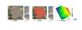
Very Nice! Have you done any solar panels yet?Attached is a recent survey I completed over Fort Lancaster State Historic Site in Texas. The Thermal IR survey came out very well. I processed the survey using SimActive's Correlator 3D software.
Drone Survey Specs:
•81 acres coverage area
•5 Ground Control Points (GCPs)
•Autel EVO II Enterprise RTK Drone
•Dual FLIR 640R Radiometric and ½ inch CMOS, 48MP Cameras
•250' AGL
•80%/80% Overlap
•10 MPG
•GSD 0.82/2.56 in/px
No. I probably won’t. At this point, I primarily use the thermal camera to photograph petroleum storage tanks every Friday for a Data Analytics Company. Also, as I shoot traditional surveys, I am flying with the dual rgb/thermal 640R. It takes a little longer but it gives me experience with processing and interpreting thermal surveys. I am a geologist so I enjoy using these tools in different ways. In December and January, I am shooting a 500 acre rgb/thermal survey over part of the Hockley Salt Dome NW of Houston. By the end of January I am hoping see some potential geologic features around the salt dome including heat flow from underlying fissures and possibly a fault or two. This is more academic but may result in a paper and/or presentation to one of the professional societies I belong to.Very Nice! Have you done any solar panels yet?
Are you flying the sites? Your drone is highly accurate...In terms of solar panels, I am working for a contractor that uses highly accurate drone data to build engineering drawings and specs for solar panel installations on top of large buildings such as Targets, etc…
Do you know what data they are using? point cloud, geo tiff, etc...build engineering drawings and specs
I am. Use RTK surveying equipment and GCPs. Also they require 2 sets of 100ft measurements laid out on the ground with arrow heads on either end. The 100 ft measurements are performed with 100ft steel measuring tapes. These are captured in the drone surveys.Are you flying the sites? Your drone is highly accurate...
What do the engineers want? Point Clouds, 2D Maps, Models or everything?
My question is what is most wanted or needed when designing a rooftop for solar or duct or piping and so on?
The goal is to retrofit the existing rooftop with solar panels. The Company I am working with creates CAD drawings from 2D Orthos and drone photos in order to provide detailed documentation of all equipment installed on the rooftop. They deliver this documentation to the company designing the solar panel installation. My role is to provide drone photos including NADIR and OBLIQUE GRID surveys of the rooftop; rooftop edge perimeter photos; 360 POV (point of view) photos shot from just above the rooftop; and building wide establishing photos. I am delivering photos only and not proving any processing services.
We use essential cookies to make this site work, and optional cookies to enhance your experience.