People, that own a 640R can you please post what the options are on the thermal settings, photos taken, and a mapping done with this sensor and software used for stitching? Any issues with mapping in the mission modes?
There are several guys on here that are looking for info and real-life photos and mapping done from the 640R. Much thanks!
This also includes vendors, several guys are looking into the 640R
also, a snapshot of the file types it saves to the SD card would be great too.
Please share data sets here! I have FLIR tools and can not wait to use them!
This drone is very unique, USA grade, and camera by FLIR which no longer supports DJI
Please share data sets here! I have FLIR tools and can not wait to use them!
This drone is very unique, USA grade, and camera by FLIR which no longer supports DJI
Along with test flights I start a long term contract shooting petroleum storage tanks. I will also use in building inspections. I will certainly share any data from test flights but I am restricted from sharing other data at this point.
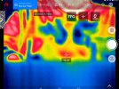
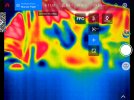
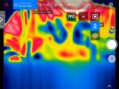
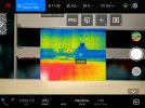
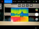
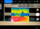
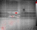
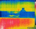
I received and installed the FLIR Dual 640R thermal camera. I took a bunch of screen captures and several thermal photos inside my office. I will begin field testing on Monday.
I received and installed the FLIR Dual 640R thermal camera. I took a bunch of screen captures and several thermal photos inside my office. I will begin field testing on Monday.
I thought the 3rd batch are actual photos versus screen captures. About 1mb each. Keep in mind that thermal images are relatively low res versus 20mp rgb images. If they are not photos please let me know.
I thought the 3rd batch are actual photos versus screen captures. About 1mb each. Keep in mind that thermal images are relatively low res versus 20mp rgb images. If they are not photos please let me know.
No problem. I hope to post more thermal images tomorrow. Any recommendations on best practices to flying a survey (thermal map) with this camera including speed, overlap, etc…? Due to trees I will likely fly at 250’ AGL. I may be able to fly lower, possibly 200 or even 150 if I restrict the area a bit more.
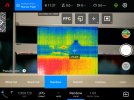
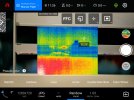
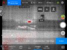
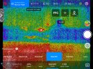
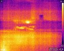
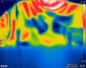
This morning I flew created a simple waypoint survey and a polygon survey. The data from the one of the waypoints can be accessed via the Dropbox link below. I am using the latest Explorer App on Smart Controller (1.0.77.1) and Firmware (V.2.3.8) on my Evo II Enterprise drone with the Dual FLIR 640R camera. Please keep in mind that this is my first attempt with a thermal camera.
1. The simple Waypoint survey I designed did not fly as designed in the Autel Explorer app. The first waypoint I had the drone go up to 394' AGL and take 10 photos rotating 16 deg from a compass heading of 290 deg to 70 deg. Waypoint #2 was the same but at 300' AGL. Waypoints #3 and #4 were a short distance away and a repeat of Waypoints #1 and #2. The drone did some strange things but did manage to take 24 thermal photos. I also included both thermal and rgb images from the Rectangular Survey. Please keep in mind that I switched between thermal and rgb in the Autel Explorer app. Not complete coverage of both thermal and rgb images. Posted to Dropbox.
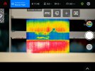
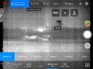
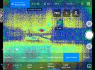
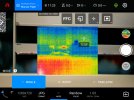
2. I had pre-programmed mission saved as a Polygon Survey created from an imported KML polygon. Each time I got a Mission upload failed. I tried modifying the existing polygon survey and even creating a new polygon survey. The same results each time. I created a simple rectangular survey and everything seemed to be fine. See screen captures.
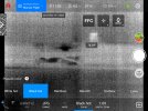
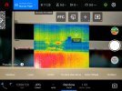
3. I thought that having a Dual 640R that I would be able to capture both thermal IR and RGB photos of the same spot. Unless I am doing something wrong, this does not appear to be the case. You have to select (make active) rgb or ir thermal resulting in one of the other not both. If this is the case, I am very disappointed. As I switched (made active) between thermal and rgb in the Explorer App, I ended up with a survey with a mix of thermal IR images and RGB images but not of the same spot. I included screen captures of what files were stored on the SD Card.
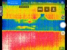
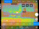
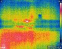
4. Regarding radiometric data. I am a bit confused about what temperature information is being saved with these thermal images. I know these are JPEG format. In one of the screen captures you can see that the dark blue area was about 86 deg F. When I look at these images in FLIR Tools and hit Auto, they should a much lower temperature range. Does this require R.JPEG (Radiometric JPEG) in order to expose temperature data in each pixel?
Please take a look at what I posted. Please feel free to comment and/or ask any questions.