

You are using an out of date browser. It may not display this or other websites correctly.
You should upgrade or use an alternative browser.
You should upgrade or use an alternative browser.
EVO 640R Data Sets
- Thread starter jmason702
- Start date
Malli35998
Well-Known Member
- Joined
- May 9, 2021
- Messages
- 311
- Reaction score
- 153
- Age
- 69
- Location
- Kingwood, TX
- Website
- www.raptoraerialservices.com
Ok. I didn’t see RJPEG as an option. I could have had RGB selected vs IR thermal. I will check again later.
Malli35998
Well-Known Member
- Joined
- May 9, 2021
- Messages
- 311
- Reaction score
- 153
- Age
- 69
- Location
- Kingwood, TX
- Website
- www.raptoraerialservices.com
Malli35998
Well-Known Member
- Joined
- May 9, 2021
- Messages
- 311
- Reaction score
- 153
- Age
- 69
- Location
- Kingwood, TX
- Website
- www.raptoraerialservices.com
Malli35998
Well-Known Member
- Joined
- May 9, 2021
- Messages
- 311
- Reaction score
- 153
- Age
- 69
- Location
- Kingwood, TX
- Website
- www.raptoraerialservices.com
Malli35998
Well-Known Member
- Joined
- May 9, 2021
- Messages
- 311
- Reaction score
- 153
- Age
- 69
- Location
- Kingwood, TX
- Website
- www.raptoraerialservices.com
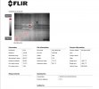
see attached it says its says FLIR Boson 640
are you sure it is 640R
Attachments


Malli35998
Well-Known Member
- Joined
- May 9, 2021
- Messages
- 311
- Reaction score
- 153
- Age
- 69
- Location
- Kingwood, TX
- Website
- www.raptoraerialservices.com
Malli35998
Well-Known Member
- Joined
- May 9, 2021
- Messages
- 311
- Reaction score
- 153
- Age
- 69
- Location
- Kingwood, TX
- Website
- www.raptoraerialservices.com
Malli35998
Well-Known Member
- Joined
- May 9, 2021
- Messages
- 311
- Reaction score
- 153
- Age
- 69
- Location
- Kingwood, TX
- Website
- www.raptoraerialservices.com
See attachments. As far as I can see, JPG is the only option. Also, confirmed XT706(Boson640R) camera. Don’t know if bug or RJPG format coming in future release.we need to look at the file types in your camera options
Attachments
Last edited:
RJPEG's as far as I know do not have RJPEG as a file extension.Well that's confusing, the output should be RJPEG....
someone correct me if I am wrong?
Notice an DJI XT2

The R is just part of the naming scheme, not the file type.
FLIR Handheld X Series

Parrot Anafi Thermal
The way I tell if it is RJPEG is if it works in FLIR Tools. If it does, then I know its an RJPEG.
Also are we sure that the 640 Dual R is not doing something similar to what the Parrot Anafi Thermal was doing? Where the RGB and Thermal Image were combined into one image. Then in FLIR Tools you could separate them or keep them as is.

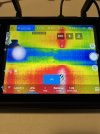
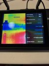
Look where I have it circled in the top left-hand corner. See if these options are available, if so then the RGB and thermal are together, and this offers some cool advantages such as:
MSX

Thermal

Fusion

Blended

PNP

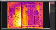
When I get time I will process the images from the Rectangle folder in Agisoft Metashape. I have jumped ship from Pix4D, as Agisoft's Tiled models blow the doors off of Pix 4 Ds models. Also Agi has Geoid 18 available which added some time consuming steps to Pix4D.
Attachments

Malli35998
Well-Known Member
- Joined
- May 9, 2021
- Messages
- 311
- Reaction score
- 153
- Age
- 69
- Location
- Kingwood, TX
- Website
- www.raptoraerialservices.com
I am going back out this morning to shoot a small thermal survey at 200’ AGL and 90/90. I will shoot thermal only, rgb only, and thermal/rgb.RJPEG's as far as I know do not have RJPEG as a file extension.
Notice an DJI XT2
View attachment 14228
The R is just part of the naming scheme, not the file type.
FLIR Handheld X Series
View attachment 14229
Parrot Anafi Thermal
View attachment 14230
The way I tell if it is RJPEG is if it works in FLIR Tools. If it does, then I know its an RJPEG.
Also are we sure that the 640 Dual R is not doing something similar to what the Parrot Anafi Thermal was doing? Where the RGB and Thermal Image were combined into one image. Then in FLIR Tools you could separate them or keep them as is.
View attachment 14232
Look where I have it circled in the top left-hand corner. See if these options are available, if so then the RGB and thermal are together, and this offers some cool advantages such as:
MSX
View attachment 14233
Thermal
View attachment 14234
Fusion
View attachment 14235
Blended
View attachment 14236
PNP
View attachment 14237
When I get time I will process the images from the Rectangle folder in Agisoft Metashape. I have jumped ship from Pix4D, as Agisoft's Tiled models blow the doors off of Pix 4 Ds models. Also Agi has Geoid 18 available which added some time consuming steps to Pix4D.
Malli35998
Well-Known Member
- Joined
- May 9, 2021
- Messages
- 311
- Reaction score
- 153
- Age
- 69
- Location
- Kingwood, TX
- Website
- www.raptoraerialservices.com
I am currently flying a 3.11 acres survey area at 7mph, 200’ AGL and 90/90 overlap. I will fly thermal only, repeat rgb only, then thermal/rgb. I will post all datasets to Dropbox later today.I am going back out this morning to shoot a small thermal survey at 200’ AGL and 90/90. I will shoot thermal only, rgb only, and thermal/rgb.
Malli35998
Well-Known Member
- Joined
- May 9, 2021
- Messages
- 311
- Reaction score
- 153
- Age
- 69
- Location
- Kingwood, TX
- Website
- www.raptoraerialservices.com
I am currently flying a 3.11 acres survey area at 7mph, 200’ AGL and 90/90 overlap. I will fly thermal only, repeat rgb only, then thermal/rgb. I will post all datasets to Dropbox later today.


Similar threads
- Replies
- 0
- Views
- 2K
- Replies
- 8
- Views
- 846
- Replies
- 2
- Views
- 2K
- Replies
- 3
- Views
- 456
- Replies
- 4
- Views
- 3K

