

You are using an out of date browser. It may not display this or other websites correctly.
You should upgrade or use an alternative browser.
You should upgrade or use an alternative browser.
EVO 640R Data Sets
- Thread starter jmason702
- Start date
Malli35998
Well-Known Member
- Joined
- May 9, 2021
- Messages
- 311
- Reaction score
- 153
- Age
- 69
- Location
- Kingwood, TX
- Website
- www.raptoraerialservices.com
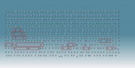
I agree. That is what was captured. I have never flown at 90/90. 200' AGL is low as well. I generally fly 250' AGL or higher and 80/80. With my 6K camera, never had this kind of problem. Flight lines were not true either. I have flown this same areas at least 100 times but not with this camera setup and to these specs. Below is what the thermal IR survey looks like in Correlator3D.alot of area missing photos, unless they did not all upload into drop box. 90/90 is alot, but PIX4D requires it.
trying to process now
Attachments
Last edited:
Malli35998
Well-Known Member
- Joined
- May 9, 2021
- Messages
- 311
- Reaction score
- 153
- Age
- 69
- Location
- Kingwood, TX
- Website
- www.raptoraerialservices.com
Do you happen to know the pixel size for the XT706 1/2" CMOS 8K Visible Camera? The Effective Focal Length (EFL) is 25.6 mm.I agree. That is what was captured. I have never flown at 90/90. 200' AGL is low as well. I generally fly 250' AGL or higher and 80/80. With my 6K camera, never had this kind of problem. Flight lines were not true either. I have flown this same areas at least 100 times but not with this camera setup and to these specs. Below is what the thermal IR survey looks like in Correlator3D.
its 48 MP, but not wile mapping, I can process that also and let you knowDo you happen to know the pixel size for the XT706 1/2" CMOS 8K Visible Camera? The Effective Focal Length (EFL) is 25.6 mm.


Attachments
I have uploaded to Drone Deploy. I have access to the Enterprise plan. I will share when its done.
I am working on an Agisoft non-radiometric processing. The files would need to be converted to tiff for Agi to work with them.
in his file set, there is a folder that reads converted, inside there are tiffs. this seems interesting... can you use these in AGII have uploaded to Drone Deploy. I have access to the Enterprise plan. I will share when its done.
I am working on an Agisoft non-radiometric processing. The files would need to be converted to tiff for Agi to work with them.
Attachments
Malli35998
Well-Known Member
- Joined
- May 9, 2021
- Messages
- 311
- Reaction score
- 153
- Age
- 69
- Location
- Kingwood, TX
- Website
- www.raptoraerialservices.com
I shot another thermal survey this morning. See link to Dropbox folder below. Below are the specs (different from yesterday). Still a lot of missing images. Any ideas why? I have reported to Autel and Advexure.
 www.dropbox.com
- 06-01-22
- RTK-Corrected
- Thermal Images Only
- SanDisk Extreme PRO 256GB MicroSD card
- 250’ AGL
- 80%/80% Overlap
- 7 mph speed
- Weather generally good. Occasional clouds and little wind.
Dropbox
www.dropbox.com
Attachments
Malli35998
Well-Known Member
- Joined
- May 9, 2021
- Messages
- 311
- Reaction score
- 153
- Age
- 69
- Location
- Kingwood, TX
- Website
- www.raptoraerialservices.com
Malli35998
Well-Known Member
- Joined
- May 9, 2021
- Messages
- 311
- Reaction score
- 153
- Age
- 69
- Location
- Kingwood, TX
- Website
- www.raptoraerialservices.com
I will change to iron color pallet using FLIR Thermal Studio. See attachment. Yes, RTK flight.will process, can you try the iron bow color pallet next time? also was this a RTK flight?
Attachments
There was an issue with the 640R stalling out on photos, is was supposed to be fixed, and to a good degree, it was, but looks like there is some more fixing to do...Still a lot of missing images. Any ideas why?
WIll do, I will run them now that I am home from work.in his file set, there is a folder that reads converted, inside there are tiffs. this seems interesting... can you use these in AGI
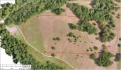
Here are the Drone Deploy results. I used the R.JPEGS. It stitched together pretty well and the radiometric data seems to be pretty good, but I think more testing would be needed with different items.
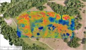
FLIR Tools measurement, Spot = 107.9 *F and Hottest is 108.4

Drone Deploy below. It did not stitch this item together that great though.
Link
DroneDeploy
 www.dronedeploy.com

THIS IS GREAT!WIll do, I will run them now that I am home from work.
Here are the Drone Deploy results. I used the R.JPEGS. It stitched together pretty well and the radiometric data seems to be pretty good, but I think more testing would be needed with different items.
FLIR Tools measurement, Spot = 107.9 *F and Hottest is 108.4
View attachment 14257
Drone Deploy below. It did not stitch this item together that great though.
Link
DroneDeploy
View attachment 14258
Malli35998
Well-Known Member
- Joined
- May 9, 2021
- Messages
- 311
- Reaction score
- 153
- Age
- 69
- Location
- Kingwood, TX
- Website
- www.raptoraerialservices.com
See folder named "Iron Color Palette"I will change to iron color pallet using FLIR Thermal Studio. See attachment. Yes, RTK flight.

Similar threads
- Replies
- 0
- Views
- 2K
- Replies
- 8
- Views
- 847
- Replies
- 2
- Views
- 2K
- Replies
- 3
- Views
- 470
- Replies
- 4
- Views
- 3K


