In the Reference Settings what you have is fine, but I always output to the correct Projected system whether UTM or State Plane. If UTM I use EGM96 for my geoid and if State Plane Geoid 12 or 18.
But I see your RS2 setup on a known point. What coordinate system is it setup on? NAD83(2011) or WGS84? I am assuming NAD83(2011) that you obtained from your RTK/NTRIP Service?
Next, I never knew that the Evo 2 RTK had Camera Calibration XMP data. But it does. I had previously used it and it worked fine(Unknowingly), but with this dataset it is the cause of the vertical shift. On this note, what is your camera angle on your Altitude Optimization oblique images?
Next, start from the beginning. I have no luck when I go back and try new settings. Make a new project.
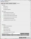
Go into Preferences/Advanced and uncheck the Load camera calibration from XMP data. For this dataset it seems to be the cause of the shift. You would think that using Auto would have it ignored. But I only had luck when it was not imported to begin with.

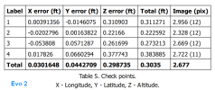
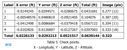
After you align the first time, Import your GCPs. For testing I only mark 10 to 15 images. Remember to mark, keep the control points checked as GCPs. When done marking uncheck the ones you want to be check points. In this case all since we want to see how low of a RMSE we can get with no GCPs.
Press the Update Transform button next to the Optimize button.
You should have pretty tight data at this point.
You can Optimize now. I used the default params checked and Fit Additional Corrections.
I didn't really find a large benefit when trying to use Gradual Selection to remove the most inaccurate points. I would assume because the area was so small and uncomplicated (Pure Guess). I tend to see drastic improvement in RMSE with the Gradual Selection setting with my large beach maps and the nightmare of the water. (Too many images to mask out).
Agisoft has always stated that using Auto will have better results than using the import Camera Calibration params. I recently did a test where I used the Calibration Params from my Phantom 4 RTK and fixed/locked it so it would only use that for alignment. It was not too good, around 10cm total RMSE.
The thing that is weird though is I always have this setting on (Load camera calibration from XMP metadata) and the Evo 2 image sets I ran came out great. Maybe there was a firmware update on the Evo 2 that now places a generic Camera Calibration in the XMP/metadata? I was just really surprised to see it in the Precalibrated section.
But I see your RS2 setup on a known point. What coordinate system is it setup on? NAD83(2011) or WGS84? I am assuming NAD83(2011) that you obtained from your RTK/NTRIP Service?
Next, I never knew that the Evo 2 RTK had Camera Calibration XMP data. But it does. I had previously used it and it worked fine(Unknowingly), but with this dataset it is the cause of the vertical shift. On this note, what is your camera angle on your Altitude Optimization oblique images?
Next, start from the beginning. I have no luck when I go back and try new settings. Make a new project.
Go into Preferences/Advanced and uncheck the Load camera calibration from XMP data. For this dataset it seems to be the cause of the shift. You would think that using Auto would have it ignored. But I only had luck when it was not imported to begin with.

After you align the first time, Import your GCPs. For testing I only mark 10 to 15 images. Remember to mark, keep the control points checked as GCPs. When done marking uncheck the ones you want to be check points. In this case all since we want to see how low of a RMSE we can get with no GCPs.
Press the Update Transform button next to the Optimize button.
You should have pretty tight data at this point.
You can Optimize now. I used the default params checked and Fit Additional Corrections.
I didn't really find a large benefit when trying to use Gradual Selection to remove the most inaccurate points. I would assume because the area was so small and uncomplicated (Pure Guess). I tend to see drastic improvement in RMSE with the Gradual Selection setting with my large beach maps and the nightmare of the water. (Too many images to mask out).
Agisoft has always stated that using Auto will have better results than using the import Camera Calibration params. I recently did a test where I used the Calibration Params from my Phantom 4 RTK and fixed/locked it so it would only use that for alignment. It was not too good, around 10cm total RMSE.
The thing that is weird though is I always have this setting on (Load camera calibration from XMP metadata) and the Evo 2 image sets I ran came out great. Maybe there was a firmware update on the Evo 2 that now places a generic Camera Calibration in the XMP/metadata? I was just really surprised to see it in the Precalibrated section.


