Earlier this fall I rented a Mavic 3 Enterprise with RTK to compare it to my Autel Evo II Enterprise with RTK.
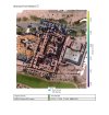
The project was gathering topography for a roughly 85 acre agricultural site.
A registered land surveyor provided six ground control point, captured with a total station.
My base station for RTK was an Emlid Reach RS2+, connected to our state CORS network. The baseline was approximately 20km. Base position was averaged for 20m. Six check points were also collected with the RS2+, averaged for just over a minute.
Admittedly, the comparison test was not completely identical, but I attempted to generally match the characteristics of the Evo and the Mavic during data collection. Parameters are compared below. In general, I knew that I wanted to complete the data collection in one flight, and I balanced the flight height and image overlap to achieve what SHOULD have been about 70% battery usage in one flight with the Evo- meaning 22 minutes planned flight time.
Temperature was slightly under 40f. Wind was 5-8 mph at the surface.
When doing mission planning for fixed wing UAVs, it's always best practice to have flight lines perpendicular to the wind. I've never viewed this as important for multirotors, but with the Evo, it definitely is. My flight lines were parallel to the wind to minimize turns on a rectangular site, and when flying into a relatively light wind, the Evo just couldn't keep up. Planned speed was 9 m/s, but into the wind actual speed dipped as low as 5 m/s, and probably averaged 6 m/s. Downwind legs maintained 9 m/s. Naturally, the battery drain was higher on the upwind legs, and it was interesting watching the "time remaining" jump around on the upwind and downwind legs.
Despite a flight plan that should have been completed with approximately 30% battery remaining, the Evo got a low battery warning, returned to home early, and landed with 21% remaining. A second flight was required to complete the data collection.
I actually completed two flights with the Mavic. The camera includes a "dewarping" algorithm. The default images are visibly fisheyed, and include black vignettes in each corner. The first flight was with the "Dewarped" setting. Ultimately decided not to use these images for the mapping test, but as a spoiler alert, it didn't seem to make much difference in Pix4d. Flight lines of the dewarped flight were parallel to wind direction. Elapsed time was 19:30, and ending battery percentage was 27%. No noticeable change in speed upwind or downwind.
So, for the Mavic mapping flight, the flight plan was actually rotated 90 degrees (flight lines perpendicular to wind). Elapsed time was 18:52, using nominally 65% of the battery. Speed was speedy! I wrote down that the mission was planned at 19 m/s (42mph), but I see now that the supposed max mission speed is 15 m/s. Regardless, it's moving right along, and seemed to be unaffected by winds aloft.
On to post processing:
Both datasets were processed in Pix4d. Three GCPs were used for this exercise, remaining points were used as check points.
Initially, the Evo had pretty poor results. I ended up using camera calibrations from other projects, and was able to improve accuracy slightly after several rounds of reoptimization. Quick reminder to always turn on "rolling shutter corrections" in Pix4d with the Evo camera- it is not on by default. The GCPs that I used are underlined below. This orientation was intentional- because it leaves point 105 hanging, and susceptible to error. Interestingly, its error was no worse than the other check points.
The Mavic had noticeably better accuracy results overall, and despite a lower GSD, higher key and match points. I find the reconstruction and image quality to be better than the Evo as well. The results shown below did not include any additional rounds of reoptimization in Pix4d- just a first "rapid" pass, followed by marking of GCP and CPs, followed by "full" keypoints image scale processing.
Note that the table below includes an average error of just the total station collected check points, as the baseline distance was relatively long with the GNSS collected check points.
EDIT: following some reports that Autel doesn't necessarily play well with Pix4d (despite an option to format EXIF data specifically for Pix4d); I decided to run this dataset in Metashape as well. Using the EXIF data and the default settings in Metashape, the results were awful. I suspect the orientation data was being read incorrectly or something similar that made it essentially unusable.
Next, I used Topodrone to PPK the image locations. Resulting image locations were very, very close to the RTK EXIF data. Using the PPK image location data improved the results slightly- worse performance on GCP accuracy, but better on checkpoints than in Pix4d. Still far worse than the Mavic. I also re-ran Metashape with "Highest" aligning accuracy, and key point limits to match Pix4d. In this case, the accuracy was degraded, and was very similar to the Pix4d results.
I'm sure there are tweaks to flight path and camera settings on both systems that could lead to improved quality. Event38 posted some results from the Mavic indicating that at high speeds rolling shutter correction should be used, which I didn't use during my testing. My goal of this test was a simple, real worksite field comparison. I hope this was helpful to other users.
In talking to other Autel owners, it seems that my results may not be representative. Throughout the year, I struggled to get satisfactory accuracy on mapping jobs using Pix4d both and Correlator3d with control and checkpoint data from GNSS and total stations, in a variety of coordinate systems and datums. It is certainly within the realm of possibility that there was something wrong with my particular airframe.

Evo Report

Mavic Report:

Autel Report from Metashape

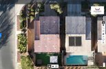
Evo Ortho Images:


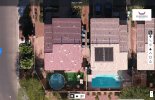
Mavic Ortho Images:


The project was gathering topography for a roughly 85 acre agricultural site.
A registered land surveyor provided six ground control point, captured with a total station.
My base station for RTK was an Emlid Reach RS2+, connected to our state CORS network. The baseline was approximately 20km. Base position was averaged for 20m. Six check points were also collected with the RS2+, averaged for just over a minute.
Admittedly, the comparison test was not completely identical, but I attempted to generally match the characteristics of the Evo and the Mavic during data collection. Parameters are compared below. In general, I knew that I wanted to complete the data collection in one flight, and I balanced the flight height and image overlap to achieve what SHOULD have been about 70% battery usage in one flight with the Evo- meaning 22 minutes planned flight time.
Temperature was slightly under 40f. Wind was 5-8 mph at the surface.
When doing mission planning for fixed wing UAVs, it's always best practice to have flight lines perpendicular to the wind. I've never viewed this as important for multirotors, but with the Evo, it definitely is. My flight lines were parallel to the wind to minimize turns on a rectangular site, and when flying into a relatively light wind, the Evo just couldn't keep up. Planned speed was 9 m/s, but into the wind actual speed dipped as low as 5 m/s, and probably averaged 6 m/s. Downwind legs maintained 9 m/s. Naturally, the battery drain was higher on the upwind legs, and it was interesting watching the "time remaining" jump around on the upwind and downwind legs.
Despite a flight plan that should have been completed with approximately 30% battery remaining, the Evo got a low battery warning, returned to home early, and landed with 21% remaining. A second flight was required to complete the data collection.
I actually completed two flights with the Mavic. The camera includes a "dewarping" algorithm. The default images are visibly fisheyed, and include black vignettes in each corner. The first flight was with the "Dewarped" setting. Ultimately decided not to use these images for the mapping test, but as a spoiler alert, it didn't seem to make much difference in Pix4d. Flight lines of the dewarped flight were parallel to wind direction. Elapsed time was 19:30, and ending battery percentage was 27%. No noticeable change in speed upwind or downwind.
So, for the Mavic mapping flight, the flight plan was actually rotated 90 degrees (flight lines perpendicular to wind). Elapsed time was 18:52, using nominally 65% of the battery. Speed was speedy! I wrote down that the mission was planned at 19 m/s (42mph), but I see now that the supposed max mission speed is 15 m/s. Regardless, it's moving right along, and seemed to be unaffected by winds aloft.
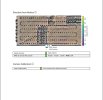
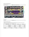
| Evo II E RTK | Mavic 3 E RTK | |
| Area | 85 acres | 85 acres |
| Planned Flights | 1. | 1. |
| Planned Duration | 22 minutes | 16 minutes |
| Flight Speed | 9 m/s | 19 m/s (?) |
| Actual Flights | 2. | 1. |
| Actual Duration | 20:50 plus 11:25 | 18:52 |
| Battery percentage at takeoff | 100% | 83% |
| Battery percentage at landing | 21% and 67% | 18% |
| Flight Height | 76m | 70m |
| Camera Mode: | Shutter Priority - 1/1250 | Shutter Priority - 1/1250 |
| GSD | 1.94cm / 0.76" | 2.11cm / .83" |
| Overlap/Sidelap % | 78/60 | 80/60 |
| Images for mapping | 724 | 764 |
On to post processing:
Both datasets were processed in Pix4d. Three GCPs were used for this exercise, remaining points were used as check points.
Initially, the Evo had pretty poor results. I ended up using camera calibrations from other projects, and was able to improve accuracy slightly after several rounds of reoptimization. Quick reminder to always turn on "rolling shutter corrections" in Pix4d with the Evo camera- it is not on by default. The GCPs that I used are underlined below. This orientation was intentional- because it leaves point 105 hanging, and susceptible to error. Interestingly, its error was no worse than the other check points.
The Mavic had noticeably better accuracy results overall, and despite a lower GSD, higher key and match points. I find the reconstruction and image quality to be better than the Evo as well. The results shown below did not include any additional rounds of reoptimization in Pix4d- just a first "rapid" pass, followed by marking of GCP and CPs, followed by "full" keypoints image scale processing.
Note that the table below includes an average error of just the total station collected check points, as the baseline distance was relatively long with the GNSS collected check points.
EDIT: following some reports that Autel doesn't necessarily play well with Pix4d (despite an option to format EXIF data specifically for Pix4d); I decided to run this dataset in Metashape as well. Using the EXIF data and the default settings in Metashape, the results were awful. I suspect the orientation data was being read incorrectly or something similar that made it essentially unusable.
Next, I used Topodrone to PPK the image locations. Resulting image locations were very, very close to the RTK EXIF data. Using the PPK image location data improved the results slightly- worse performance on GCP accuracy, but better on checkpoints than in Pix4d. Still far worse than the Mavic. I also re-ran Metashape with "Highest" aligning accuracy, and key point limits to match Pix4d. In this case, the accuracy was degraded, and was very similar to the Pix4d results.
I'm sure there are tweaks to flight path and camera settings on both systems that could lead to improved quality. Event38 posted some results from the Mavic indicating that at high speeds rolling shutter correction should be used, which I didn't use during my testing. My goal of this test was a simple, real worksite field comparison. I hope this was helpful to other users.
In talking to other Autel owners, it seems that my results may not be representative. Throughout the year, I struggled to get satisfactory accuracy on mapping jobs using Pix4d both and Correlator3d with control and checkpoint data from GNSS and total stations, in a variety of coordinate systems and datums. It is certainly within the realm of possibility that there was something wrong with my particular airframe.
| Evo II E RTK- Pix4d | Mavic 3 E RTK- Pix4d | Evo II RTK- Metashape | |
| Calibrated Images | 724 of 724 | 759 of 764 | 724 |
| Keypoints (median) | 76,190 | 77,605 | 40,000 |
| Matchpoints (median) | 38,919 | 49,013 | 4,000 |
| GCP 3d RMS Error | 0.026 foot | 0.018 foot | 0.146 foot |
| Check Point Mean Error (x/y/z) | 0.447/0.368/0.494 feet | 0.016/0.007/0.049 | 0.201/0.064/0.155 |
Evo Report
Mavic Report:
Autel Report from Metashape
Evo Ortho Images:
Mavic Ortho Images:
Last edited: