Welcome, Autel Pilots!
Join our free Autel drone community today!
Join Us

Bug in the .a-s-s

wanderer

Member
Joined
Sep 9, 2019
Messages
17
Reaction score
24
Location
Orange County, California
Website
mydroneviewer.com
So I've been probing my .a-s-s logs and have made a few discoveries. ;)

Just to refresh, .a-s-s files are a real thing and can be turned on in the app settings. (The actual extension is .a-s-s without the dashes. I'm using the dashes since the forum software changes the this to .a**).

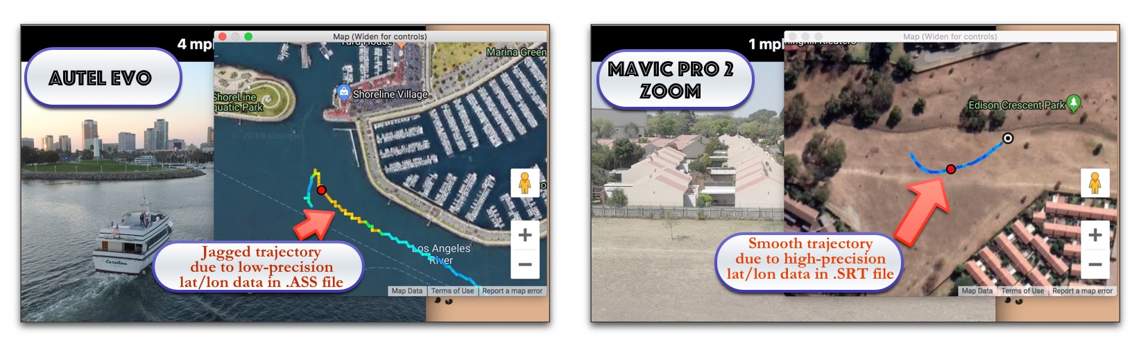
When enabled, the .a-s-s files contain per-video trajectory data, which is used by DroneViewer for synchronized playback with the video. The .a-s-s files are saved on the SD card alongside the video files. This makes the trajectory data easily and conveniently available (thanks Autel!). Not surprisingly, DJI also records per-video trajectory data in their SRT file, which is enabled in a similar manner.

The problems with the EVO .a-s-s files are as follows:
  1. The longitude value is recorded with an extraneous character. See snippet below. Notice the current position longitude is "-117.-9605". The second '-' sign should not be there! Funny thing is that the home point longitude is recorded correctly.
  2. The latitude and longitude coordinates are recorded out to only 4 digits past the decimal. This equates to a resolution of approximately 33 feet! When plotted on a map, the results is a stair-step trajectory pattern, even though the drone is flying in a straight line. The coordinates should be recorded out to 6 decimal places (0.3 feet). Notice the SRT file for the Mavic Pro 2 Zoom records out to 6 decimal places and the trajectory is smooth, as shown in the graphic below.
  3. A minor bug is that the data record has a "\N" in it, when I think they meant to write "\n" (carriage return).
  4. Another minor bug is that Latitude and Longitude ordinal values (N/S or E/W) are printed out, but these can be inferred by the positivity or negativity of the latitude or longitude values. For example, -117 longitude implies "West" so having both a negative sign and "W" is redundant. Like I said, it's a minor nit!
So my question is: Does anyone on the forum have a good technical contact at Autel? I would like to discuss these issues with them so I can support the EVO in DroneViewer without resorting to hacks. BTW, the EVO is an awesome drone. I've only had it a week and am very impressed.

Thanks!

Autel EVO .A-S-S file, v4.00+:
HOME(-117.9606, 33.6324) 2019.9.8 16:49:24\NGPS(W: -117.-9605, N: 33.6323, -37) ReH:0 \NISO:100 SHUTTER:1000 EV:0 F-NUM:2.8

Mavic Pro 2 Zoom SRT file:
[latitude : 60.192410] [longtitude : 24.843398]

evo-vs-mavic-pro-2-zoom.jpg
 
  • Like
Reactions: Ansia
So my question is: Does anyone on the forum have a good technical contact at Autel? I would like to discuss these issues with them so I can support the EVO in DroneViewer without resorting to hacks. BTW, the EVO is an awesome drone. I've only had it a week and am very impressed.

As a first contact reference point I would suggest passing on your details and discussion here to the Customer Support email address and put an Attention: Luke Fletcher directive on your message. He is the supervisor for Customer Support and will be able to give you further guidance as to how to proceed with your endeavors to support Autel and the EVO. They are able to direct your concerns and discoveries to the appropriate team for consideration and action.

[email protected]

Their support team is quite responsive and bugs, glitches and quirks that are reported are quickly addressed at their morning meetings for further investigation. You may be able to get those "typographical" errors resolved by just reporting them without jumping through hoops and see the changes in the next update or two. I've turned in a couple of things that were erroneous in their instructions for use of the prop guards and they were appreciative.

One thing to mention, when I view and run my Flight Log records the flight paths displayed as an overlay on my Google map are butter smooth at any level of zoom. Not a pixel out of place. It appears that perhaps the a-s-s files are recording an abbreviated string of the flight coordinates compared to what is saved in the Flight Log Records of each flight. Below is a snippet of one of my recent flights. As you can see by the coordinates representing the position of the drone they are saved out to six decimal places and produce a smooth representation of the flight. Or am I barking up the wrong tree? :)

Screenshot_20190915-200812_Autel Explorer.jpg
 
In order to do this, you would have to sign up for the SDK program.


You will have to create an account first.

Hope it helps.
I would believe this would be the best route since Autel suggested doing it this way. This should go directly to the department it needs to.
Hopefully, MAYBE something could also be developed for the XSP? Sorry, just dreaming lol.
 
Last edited:
  • Like
Reactions: Ansia
I would believe this would be the best route since Autel suggested doing it this way. This should go directly to the department it needs to.
Hopefully, MAYBE something could also be developed for the XSP? Sorry, just dreaming lol.
What is XSP? Never heard of it. Is that an acronysm for extra special person? Wow, you made me ☺️
 
  • Wow
Reactions: Tufargon
In order to do this, you would have to sign up for the SDK program.


You will have to create an account first.

Hope it helps.

Thanks, @Ansia. I created an account. It appears their SDK program is more geared to Android/iOS rather than Mac/Windows, but this puts me on Autel's radar.
 
  • Like
Reactions: Ansia
As a first contact reference point I would suggest passing on your details and discussion here to the Customer Support email address and put an Attention: Luke Fletcher directive on your message. He is the supervisor for Customer Support and will be able to give you further guidance as to how to proceed with your endeavors to support Autel and the EVO....

...Below is a snippet of one of my recent flights. As you can see by the coordinates representing the position of the drone they are saved out to six decimal places and produce a smooth representation of the flight. Or am I barking up the wrong tree? :)

Ah, I'm jealous of those 6-digits! It's frustrating that the extra data is available but they chose not write it to the a-s-s file. I will contact support as you suggested!
 
Ah, I'm jealous of those 6-digits! It's frustrating that the extra data is available but they chose not write it to the a-s-s file. I will contact support as you suggested!
Yes indeed, since you already have developed the software and it appears to be compatible with Autel's data files, the issues you have brought up fall into the category of "general housekeeping" and should be addressed by their programmers and corrected when those modules are reissued in an update. The typos are obviously in need of correcting.

As far as the mismatch of the decimal places, my money is on the possibility that the coding for the Flight Log module was not done by the same person that created the .a-s-s database and they just weren't on the same page. A common occurrence when so many programmers are working on individual projects that end up assembled as a complete unit. (You know! I saw your own team list.) It usually gets sorted out during beta but in your case, since the EVO flies without the .a-s-s database created and saved, i.e. selected and turned 'on' in the app even if it was the same person coding both sections they may not have realized the .a-s-s information needed to also be stretched out to six decimal places because someone like your group has come up with a very innovative way to use the information in a secondary way.

If you haven't already I'd just itemize your discoveries and send them to tech support to be put on their To Do list.
 
...the issues you have brought up fall into the category of "general housekeeping" and should be addressed by their programmers and corrected when those modules are reissued in an update. The typos are obviously in need of correcting.

Agreed. Btw, I'm not singling Autel out. DJI still spells "longitude" as "longtitude" in their MP2 Zoom SRT file. :rolleyes: As a programmer, I've had a few of these issues myself.

As far as the mismatch of the decimal places, my money is on the possibility that the coding for the Flight Log module was not done by the same person that created the .a-s-s database and they just weren't on the same page.

This is probably the case. I'm surprised no other users reported these issues as they are rather obvious. Am I the only one who uses this file?

If you haven't already I'd just itemize your discoveries and send them to tech support to be put on their To Do list.

Done. Looking forward to a response.
 
Done. Looking forward to a response.
@wanderer John?, I'm sure you will eventually be successful in getting a 'cleaned up' data resource that will complement your app and its usefulness for EVO drone users. I've already started considering my own possibilities for its use. And I love to Buy American and support our own economy too!

A suggestion on your Buy Now links....they don't come right out and indicate PayPal is one of the methods of payment you offer, only the listed credit cards. With all the hacking and security breaches nowadays online buyers are getting more reluctant to provide a specific CC # and account details VS using PayPal where businesses never see critical information. I'd rather just worry about one company having a breach than dozens of online businesses with my details. So adding PayPal logo to your accepted list of CC's up front may tempt a few more customers. I did find out you offer PayPal in the payment section of the process.

I have a request. Once the corrections are made so you can update your User's Manual to include EVO and its resource (a-s-s) files, when you add Autel EVO in your "Drones that are compatible with DroneViewer" could you by chance add us alphabetically? Autel EVO would be at the top of your list. We could use all the feathers in our caps we can get which may encourage other 3rd party developers to consider supporting our platform too. TIA ;)
 
Last edited:
@wanderer
If you are the developer of the software in your first post would you please not use live links to it unless you become a preferred vendor on the forum. It is nice to see someone trying to provide 3rd party software but we cannot allow free advertising with live links as per the rules of the forum. That post has been edited.
Having the live link in your avatar is fine and follows the rules but any posts you link to your software will either be edited or deleted.
 

Latest threads

Members online

Forum statistics

Threads
11,278
Messages
102,940
Members
9,873
Latest member
kwoody