- Joined
- May 9, 2021
- Messages
- 311
- Reaction score
- 153
- Age
- 69
- Location
- Kingwood, TX
- Website
- www.raptoraerialservices.com


what software are you using to produce thermal maps?Unfortunately, some days are just frustrating. We are all trying to push the technology and our own knowledge to solve problems and provide answers. I am so glad these Forums are here for all of us to share our knowledge and experience. I really appreciate you all taking the time to contribute your expertise.
what software are you using to produce thermal maps?
SimActive Correlator3D. It seems to do a pretty good job. This test survey was shot over a 30 acre area at 250’ AGL, 80%/80% overlap and 10 mph. Total number of photos was 2297.what software are you using to produce thermal maps?
I bought a floating license several years ago. I believe I paid about $4,500 for the license and $1,500 every 2 years for maintenance.how much is sim active if you dont mind?
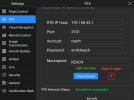
Yup, they heard that from us as well. Those no reason why the device can't maintain the connection and then the drone would hop right back on without having to manually trigger it. Unfortunately it might be a design flaw that's not easy to work around depending on how the hardware is configured.The whole battery change process during a Mission is still very cumbersome. One suggestion that I will submit to Autel is to add a check box that would allow for the RTK Network to login automatically (default?) versus having to hit the Login button each time.
Same. We cut maintenance two updates ago and it is working just fine for what we infrequently use it for but if some hot feature comes out we'll hop back on.I both a floating license several years ago. I believe I paid about $4,500 for the license and $1,500 every 2 years for maintenance.
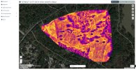
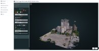
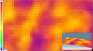
Nice. Looks like you're getting dialed in. I'm out in the Badlands again today. Testing a new router. Not bad but still not fixing any faster than 5 minutes.Attached are plots showing the RGB Visible Survey, Thermal IR Survey, and the Thermal IR survey overlain on the RGB Visible Survey over a 30 acres area known as East End Park in Kingwood, TX. The Thermal IR Survey was shot with an Autel Dual 640R camera at 250' AGL, 80%/80% Overlap and 10 MPH. It generated ~2275 Thermal IR photos and ~2275 RGB Visible photos. Both Surveys were processed with SimActive's Correlator3D software. Overall the thermal IR survey came out quite well.


Looks very CLEANAttached are plots showing the RGB Visible Survey, Thermal IR Survey, and the Thermal IR survey overlain on the RGB Visible Survey over a 30 acres area known as East End Park in Kingwood, TX. The Thermal IR Survey was shot with an Autel Dual 640R camera at 250' AGL, 80%/80% Overlap and 10 MPH. It generated ~2275 Thermal IR photos and ~2275 RGB Visible photos. Both Surveys were processed with SimActive's Correlator3D software. Overall the thermal IR survey came out quite well.
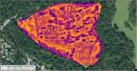
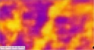
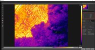
I also processed the thermal IR survey with WebODM (WebODM Drone Software - OpenDroneMap). It came out quite good. See attached screen captures. Left image was processed with WebODM and the right image processed with Correlator3D.Looks very CLEAN
Have you tried using this to find ground water? We have found that early morning will produce heat signatures close enough that you can guesstimate where ground water would be for exploration. We have a lot of it but also a lot of limestone 4-5ft down in many areas so it is easy to tell which is which. My next endeavor is to use thermal to prove curing of concrete tilt-wall panels. If we can shave a day or two that is a big deal on the schedule.I also processed the thermal IR survey with WebODM (WebODM Drone Software - OpenDroneMap). It came out quite good. See attached screen captures. Left image was processed with WebODM and the right image processed with Correlator3D.
Have you tried using this to find ground water? We have found that early morning will produce heat signatures close enough that you can guesstimate where ground water would be for exploration. We have a lot of it but also a lot of limestone 4-5ft down in many areas so it is easy to tell which is which. My next endeavor is to use thermal to prove curing of concrete tilt-wall panels. If we can shave a day or two that is a big deal on the schedule.
Certainly using a thermal camera can find ground water. A couple of years ago I was going to do some work along the coast of Georgia but I had problems with my Zenmuse XTR camera, so I had to withdraw from the project. I checked on the Project and the technique worked well. I have a small project in Menard, TX, later in the year that might have ground water/springs present. I extended the survey to try and identify some ground water/springs. I plan to shoot as early in the morning as I can.
Does WEB OMD take into account the RTK metadata in the photos? To make the map very much more accurate... and does it generate an accurate report of some kind telling you how well it thinks the map is geo-referenced?I also processed the thermal IR survey with WebODM (WebODM Drone Software - OpenDroneMap). It came out quite good. See attached screen captures. Left image was processed with WebODM and the right image processed with Correlator3D.
Check out the following links below from the WebODM Community Forum. It might be worth joining. I bought a license because it is cheap and has a good following. I haven't used WebODM extensively.Does WEB OMD take into account the RTK metadata in the photos? To make the map very much more accurate... and does it generate an accurate report of some kind telling you how well it thinks the map is geo-referenced?
Also any other cool stuff it can do? There is no trial package. My concern is, does it work well with RTK drones...

 community.opendronemap.org
community.opendronemap.org
community.opendronemap.org
community.opendronemap.org
community.opendronemap.org
I just processed a thermal map in WebOMD using the 640T and the converter tool to Rjpeg. Turned out very well. Have you been able to read temps on WebOMD or SIM ACTIVE?I also processed the thermal IR survey with WebODM (WebODM Drone Software - OpenDroneMap). It came out quite good. See attached screen captures. Left image was processed with WebODM and the right image processed with Correlator3D.
The only info I came across in Simactive C3D is provided in the link below. You disable the color balancing option in the Mosaic Creation dialog.I just processed a thermal map in WebOMD using the 640T and the converter tool to Rjpeg. Turned out very well. Have you been able to read temps on WebOMD or SIM ACTIVE?


We use essential cookies to make this site work, and optional cookies to enhance your experience.