NO ****! was you doing picture in picture to capture both RGB and IR?
Hi jmason702,
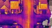
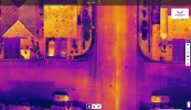
RGB 7680x4320 works for sure in missions. I just checked a polygon mission in which RGB + IR were captured simultaneously and there the RGB resolution was 3840x2160 only.
I have to check that again. Probably I mixed this up with the PIV-function (Picture in Video), where you can record RGB video at 7680x4320 pixel, IR video at 640x512 and RGB+IR PIP at 1280x720 AND AT THE SAME TIME take corresponding photos (manually or automatically, starting from a 5 s interval). So you get three videos and the three different types of photo series, which are georeferenced (IR jepegs without TIF and without IRG radiometric data).
Sorry for probaly confusing these two separate functionalities. (Maybe I was too fascinated by the PIV function and missions with RGB 7680x4320 at the same time...)
I will check if reducing the ground speed could further raise RGB resolution for those dual missions.
Nevertheless an 8.3 MP RGB imagery (for visual inspection or mapping) in conjunction with 640x512 thermals within one flight are still remarkable.
EDIT: I have to check all these values again. Probably RGB 3840x2160 also applies for PIV-imagery when RGB+IR are recorded at the same time. (7680x4320 pictures only with 7680x4320 videos...) I got confused with the numbers on the screen and checking the properties. Nevertheless the pixel resolutions are still very good IMO.
EDIT 2:
For RGB+IR+PIP imagery and PIV (Picture in Video): RGB 3840x2160, IR 640x512, PIP 1280x720
For mission and PIV imagery in RGB only: 7680x4320