Welcome, Autel Pilots!
Join our free Autel drone community today!
Join Us

3000 Photo Map, and Metashape report

Okay I did a test as follows.

A previous Phantom 4 RTK map that were all nadir images and had Altitude Optimization enabled (1 flight line of oblique images from the outside corner to the center of the area).

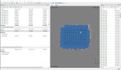
Altitude Optimization image location. Notice the flight line from 10 oclock, it starts from the outside and works to the center and these are oblique images.

1658193425196.png
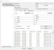
I reprocessed it as just the nadir images without Altitude Optimization (Obliques). No GCPs. I only used 4 of the control points as Check Points to save time. I used the DJI camera calibration parameters imported automatically from the XMP. I used the same default settings as previously when the RMSE was:
1658192829841.png

I then had a vertical shift as I expected.

1658192878256.png

I next used Fit Additional Corrections which I had not done in the original test with Altitude Optimization enabled.

The results were:

1658193029783.png


Next Test

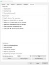
Same as above except I did NOT import the DJI camera calibration parameters from XMP. I will let Agisoft do the camera calibration on its own.

So this test is: No DJI Camera Calibration parameters, No GCPs. 4 Check Points. No Altitude Optimization. Default parameters in workflow until noted later.

100 out of 252 images failed to align. This is due to the Phantom 4 RTK providing its images "warped" by default.
So the DJI Camera Calibration parameters are a great starting point when aligning. There is an option in the settings on Pilot/RTK to deliver "dewarped" images but I do not use it.

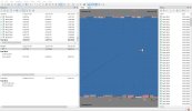
I Optimized and ran Align images again and the results were:

Altitude shifted up 10 to 11 inches.

I next Optimized with Fit Additional Corrections and the RMSE was:

1658195869290.png


I think these tests show some interesting things.
1. The DJI Camera Parameters saved a step in getting the warped images to align, but the end result was similar.
2. The addition of oblique images in just a single flight line is very effective.

My other tests using all obliques or nadir combined with obliques always come out with really tight RMSE.

Now I am very curious to see if I can get my old Phantom 4 Pro V2 with PPK kit to be able to eliminate the single GCP using Reference Preselection Source along with Capture Distance along with Fit Additional Corrections in Optimize.

Stay tuned!
 
  • Like
Reactions: jmason702
Thanks for your efforts posting all of that @jaja6009 I appreciate the effort.

Actually, I had already set the preference but I was not getting any adjustment showing up when I was exploring.
Here is my post on Agisoft (Load camera calibration from XMP)

Now, after seeing your screenshots, I started digging. I now see some of my photo sets do show a calibration where the one I was looking at then does not. I thought maybe since I had used both the normal remote and the sdk remote with Ground Station Pro that the exif might be being written differently. But what I think I discovered is that sometimes dewarp was off and sometimes on and there are some more parameter values in the exif that don't exist when it's off. That must be where the calibration parameters are coming from.

Thoughts?

And, 60 degrees on the obliques surprises me. I was guessing closer to 75 or 80, wow. Again, very interesting!
 
Last edited:
So this test is: No DJI Camera Calibration parameters, No GCPs. 4 Check Points. No Altitude Optimization. Default parameters in workflow until noted later.

100 out of 252 images failed to align. This is due to the Phantom 4 RTK providing its images "warped" by default.
So the DJI Camera Calibration parameters are a great starting point when aligning. There is an option in the settings on Pilot/RTK to deliver "dewarped" images but I do not use it.

I have never had images that didn't align; dewarp on of off made no difference. Strange one there.
 
Thanks for your efforts posting all of that @jaja6009 I appreciate the effort.

Actually, I had already set the preference but I was not getting any adjustment showing up when I was exploring.
Here is my post on Agisoft (Load camera calibration from XMP)

Now, after seeing your screenshots, I started digging. I now see some of my photo sets do show a calibration where the one I was looking at then does not. I thought maybe since I had used both the normal remote and the sdk remote with Ground Station Pro that the exif might be being written differently. But what I think I discovered is that sometimes dewarp was off and sometimes on and there are some more parameter values in the exif that don't exist when it's off. That must be where the calibration parameters are coming from.

Thoughts?

And, 60 degrees on the obliques surprises me. I was guessing closer to 75 or 80, wow. Again, very interesting!

I think how you explained it with the dewarp being on and off is the explanation.

The 60 degrees is the default when using the 3D Photogrammetry Double Grid.

The images that didn't align puzzled me too. It wasn't like it was just grass fields.

Well here is my Phantom 4 V2 with PPK test.

As expected there was a vertical shift. The manufacturer of the kit states you must use 1 GCP.

1658202686395.png

Above was with Reference Preselection Source and Capture Distance set at the average relative height.

I then ran Optimization with Fit Additional Corrections and the result was:

1658203197177.png

Go figure. Well 1 GCP isn't asking too much.

And this is with the recommended 1 GCP.

1658203661208.png


jmason,

I know you have a lot of images, but try the Reference Preselection Source, Capture Distance (Use your average relative height off the ground in meters) and then Optimization with Fit Additional Corrections.

I am very curious to see if this helps. The Phantom 4 RTK in my test showed that the DJI camera parameters were a great starting point, but Agisoft could get the vertical error down on its own.
And that you are using oblique images in your dataset to begin with, maybe we will attempt to change some settings.

Maybe do a small test and increase your oblique angle to 60 degrees and mix them up with a nadir path too.

Okay that's it for testing, I have to process my own 3000+ image project and this is gonna take a while.
 
  • Like
Reactions: jmason702
You are awesome!
I think how you explained it with the dewarp being on and off is the explanation.

The 60 degrees is the default when using the 3D Photogrammetry Double Grid.

The images that didn't align puzzled me too. It wasn't like it was just grass fields.

Well here is my Phantom 4 V2 with PPK test.

As expected there was a vertical shift. The manufacturer of the kit states you must use 1 GCP.

View attachment 14569

Above was with Reference Preselection Source and Capture Distance set at the average relative height.

I then ran Optimization with Fit Additional Corrections and the result was:

View attachment 14570

Go figure. Well 1 GCP isn't asking too much.

And this is with the recommended 1 GCP.

View attachment 14571


jmason,

I know you have a lot of images, but try the Reference Preselection Source, Capture Distance (Use your average relative height off the ground in meters) and then Optimization with Fit Additional Corrections.

I am very curious to see if this helps. The Phantom 4 RTK in my test showed that the DJI camera parameters were a great starting point, but Agisoft could get the vertical error down on its own.
And that you are using oblique images in your dataset to begin with, maybe we will attempt to change some settings.

Maybe do a small test and increase your oblique angle to 60 degrees and mix them up with a nadir path too.

Okay that's it for testing, I have to process my own 3000+ image project and this is gonna take a while.
Will do, thank you
Reference Preselection Source
where is this located in the software? off to work, Ill do it after
 
where is this located in the software? off to work, Ill do it after
File menu, WORKFLOW > ALIGN PHOTOS

This setting has more to do with efficiency; telling the processor which images should have points in common, than it does with the resulting accuracy of the model. Using "source" for geo-tagged images is a good option.


A.jpg
 
  • Like
Reactions: jmason702
I always thought that oblique shots would mess up your accuracy, but his study shows completely different!
I just assumed if shooting at an angle the data attached to the image would be off...
I am processing a single grid I did on one of the maps at 70 degrees, just those images alone

attached is how I have been doing it, everything else stays in default... any concerns?
 

Attachments

  • Screenshot 2022-07-19 050136.jpg
    Screenshot 2022-07-19 050136.jpg
    249.3 KB · Views: 8
  • Screenshot 2022-07-19 050232.jpg
    Screenshot 2022-07-19 050232.jpg
    149.4 KB · Views: 8
I will do a small map this weekend, around 500 photos, one cross hatch nadir, and other crosshatch 65 degrees both 175 AGL, and 1 point at 30 min sit time
 
  • Like
Reactions: jaja6009
Got it. Did you have an oblique only / single grid in the comparison matrix, or just the oblique double grid?
No, I have never done an oblique only single. I follow their default flight plans mostly.

Another strategy is to fly at the altitude you always map at. Load the area with GCPs. Then process. Take the Camera Calibration when done and save it so you can use it for other maps flown at that altitude.

I have not tested it yet since my current workflows are working great.
 
  • Like
Reactions: jmason702
jaja6009 - I wish you had an Autel too! Nebraska State Patrol uses Evo2's (plain model) for their accident reconstruction and several counties also use plain Evo2s for various tasks as well.

I run an Evo2v1 for many unofficial mapping missions and often think about stepping into the more in-depth mapping that I read about here.
 
About 400 photos each, one was cross-hatch at 90 down with altitude correction set to on, and the other was cross hatch 65 degrees with altitude on. 175 AGL on each, everything was the same just the camera angle was different
 

Attachments

  • Test Home 65 degree.jpg
    Test Home 65 degree.jpg
    516.2 KB · Views: 9
  • Test Home 90 degree.jpg
    Test Home 90 degree.jpg
    499 KB · Views: 8

Latest threads

Members online

Forum statistics

Threads
11,281
Messages
102,955
Members
9,878
Latest member
Elio-Italy