Welcome, Autel Pilots!
Join our free Autel drone community today!
Join Us

Waypoint mission flights using *.csv, *kml files or with PC

jkproduction

New Member
Joined
Oct 15, 2021
Messages
4
Reaction score
0
Age
43
I am carrying out a drone AI learning data construction project to extract the output of food crops nationwide in Korea.
QGIS is being used as a program in charge.
Waypoint mission flights using *.csv, *kml files that can be printed and used from this are essential.
It is efficient to make Waypoint missions with a PC, so I hope you can work with a PC.
DJI can do that through Litchi app's mission hub.
Is there a way point mission for AUTEL EVO2 with a similar process like this?
 
Not to my knowledge. This would be a big leg up for Autel if they could get this ability to read and utilize kml/kmz files to actually work. Mission planning on a smart phone is not so smart!
 
  • Like
Reactions: gschulzuio
Not at Autel, impossible to achieve on their dedicated PX4 flight platform. Mission flights boil down to straight lines between points and a stop or slowdown at each point. Impossible to have the potential and flexibility of DJI missions.
 
@claudius62

For now i'm working on re-coding AE here and there to get this behavior from video.
No yaw controll but it would be much more efficient than current long pauses in !mapping scenarios!.

If Autel use PX4 for autopilot it is realy simple to add spline waypoints (used by Yuneec as "Curve Cable Cam" ) [it just requires to change waypoint type, mavlink command exists in AE]
Spending some time on spline geometry allows to create arcs... Arcs + splines + lines are all what i need for autonomus roads video inspections.
PX4 GitHub - PX4/PX4-Autopilot: PX4 Autopilot Software is not dead, it gets new features/fixes everyday.
If i could get to the drone FW without loosing warranty... Gonna dig there right after it.
 
  • Like
Reactions: jkproduction
Not to my knowledge. This would be a big leg up for Autel if they could get this ability to read and utilize kml/kmz files to actually work. Mission planning on a smart phone is not so smart!
Autel EVO ll can be applied with kml/kmz files.
 
Not to my knowledge. This would be a big leg up for Autel if they could get this ability to read and utilize kml/kmz files to actually work. Mission planning on a smart phone is not so smart!
Yup, and then export/import updated missions from one device/phone/tablet to another, rather basic, 101 feature functionality.
 
@Gpop24 can you try to load this files?
link: KML TEST - Google Drive
test1: simple 10 waypoints mission
test2: simple polygonal mapping mission
youtube:
I was able to load the test1.kml file without issue, thanks! Now I just need to figure out what is in the kml files that do not load properly. Curious, it looks like you were interacting with the explorer app on a PC. How are you accomplishing that?
 
como lo hiciste?, yo pude crear la carpeta dentro del celular pero cuando trato de abrir tus kml la aplicacion de autel se cierra
The ability to import kml files from external sources seems to be difficult to utilize in a reliable way. It was difficult to get it to import a file. For me, I first had to create a mission on the explorer app and save it before any uploaded file was even visible.
 
The ability to import kml files from external sources seems to be difficult to utilize in a reliable way. It was difficult to get it to import a file. For me, I first had to create a mission on the explorer app and save it before any uploaded file was even visible.
The good news is the ability to for example export a Litchi mission and import as a kml, at least then have the waypoints to work with. Having good success with this now having found a few tricks including disable curves in the Litchi mission. The bad news is there is some cleanup to do if duplicate waypoints get brought over as part of the kml, plus, have lost pois, as well as waypoint actions and issues with altitudes.

Have also seen where autel throws an error if trying to rename an imported mission from litchi if using kml vs. vml (you can import both, one throws an error on rename). For example, from litchi you can export as a klm and as a vlm (besides as csv etc). The klm can be imported into to autel, renamed, etc without an error from the explorer app. However if you import the vlm, it will load the waypoints, you can edit the waypoints, however if you try to rename the mission the explorer app will throw an error.

The issue continues to be you can import the waypoints, even alt, however takes time to add or fix pois, then go to waypoints and set poi if applicable, adjust altitudes, cruising speed, and adding waypoint actions. However the biggest issue is if after taking the time to do the above on the app (desktop would help speed things up), you save, and make a local copy, however you cant export/save that mission to another device/app. Those missions and time to set them up now have an affinity to the device they are on, if something happens to that device, sol.
 
Last edited:
I was able to load the test1.kml file without issue, thanks! Now I just need to figure out what is in the kml files that do not load properly. Curious, it looks like you were interacting with the explorer app on a PC. How are you accomplishing that?
Do you still have this file because it is not available any more
Thank you in advance for your help
 
@Gpop24 can you try to load this files?
link: KML TEST - Google Drive
test1: simple 10 waypoints mission
test2: simple polygonal mapping mission
youtube:
I understand that you have a kml file that can be imported in the Autel explorer. I tried to download the file but it is not there anymore. Is it possible to put it online again I would be very grateful. Thanks in advance for your help
 
I understand that you have a kml file that can be imported in the Autel explorer. I tried to download the file but it is not there anymore. Is it possible to put it online again I would be very grateful. Thanks in advance for your help
If you would like to send me your email address, I can send it to you.
 
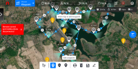
Screenshot_20211210-180505.pngHi,
Looked into the file you send me and found a lot of simulairity with the kml that comes out of google earth. I exported a route that I made in litchi, deleted the POI’s that where in i tand then from google chrome I exported the file as a VLM (extension in chrome). Opened the file in google earth and then save as a kml file. Download this in your Autel explorer and the route is imported. After that I again put in the POI’s and the result you can see in the screenshot. The route is on Bali.
the only point is that it only works in android. dont understand why but maybe this has something to do with the fact that android works with google maps. in IOS apple maps is used in the Autel explorer
 

Latest threads

Members online

No members online now.

Forum statistics

Threads
11,286
Messages
103,005
Members
9,892
Latest member
hakles