I could not find an easy way to transfer my Missions from the Standard Controller to the Smart Controller, so I decided to see what I could knock up.
Attached is a HTML (Download the TXT file and change the extension to ".html") file that will convert Waypoint and Rectangle Missions from the JSON TXT file to a basic KML file that can be used to import back into the Explorer app.
It does NOT do altitude, actions, gimble angle etc... Just the Latitude and longitudes points.
It uses simple, poorly written Javascript and requires no internet connection.
How to use:
LICENCE: You can do what ever you want with it and I take no responsibility for anything... ever.
Attached is a HTML (Download the TXT file and change the extension to ".html") file that will convert Waypoint and Rectangle Missions from the JSON TXT file to a basic KML file that can be used to import back into the Explorer app.
It does NOT do altitude, actions, gimble angle etc... Just the Latitude and longitudes points.
It uses simple, poorly written Javascript and requires no internet connection.
How to use:
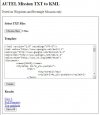
- Select "Choose Files" to browser your local file system. It supports multiple files
- Change the KML Template if desired.
- There are 3 placeholders
- [POINTS] - The Lat/long
- [NAME] - File Name without extension
- [PLACE] - File Name without extension
- There are 3 placeholders
- Select the "Create" button
- Each file will either produce an error message or a download link
- Select "Save All" or click the hyperlink for individual files
LICENCE: You can do what ever you want with it and I take no responsibility for anything... ever.