

You are using an out of date browser. It may not display this or other websites correctly.
You should upgrade or use an alternative browser.
You should upgrade or use an alternative browser.
Need Help Please, Convert Cords
- Thread starter jmason702
- Start date
Use this PleaseNeed to convert to Lat Long, WGS 84 with Ellipsoid elevation......
Attachments
See if you can do a reverse through
You will need to know your zone
You will need to know your zone
Malli35998
Well-Known Member
- Joined
- May 9, 2021
- Messages
- 311
- Reaction score
- 153
- Age
- 69
- Location
- Kingwood, TX
- Website
- www.raptoraerialservices.com
Check out NGS Coordinate Conversion and Transformation Tool (NCAT)Need to convert to Lat Long, WGS 84 with Ellipsoid elevation......
A better tool is Vdatum see Online VDatum: Vertical Datums Transformation. But you need much more data: Datum, Coordinate reference, units of measure. Not impossible, just a little more work. The NOAA tool will step you through the questions.


Did you need this in WGS 84 or NAD 83 (2011)?
Those values are for NAD83(2011) since that is the datum.
Also I got the same answer as ML on Emlid which slightly disagrees. I got it from the NGS Geoid 12 Computation Tool's given undulation and the orthometric elevation you gave.
Too bad they closed the thread, as I wanted to see if someone could say why I got something different by 8mm. Maybe NGS's grid is of higher resolution than the tiff that Emlid is using.
No.
Geoid 18 Tool
Geoid 12B Tool
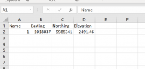
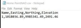
Ellipsoid Elevation 2491.46
Place the coordinates (Geographic NAD 83 (2011, not the State Plane) in the tool.
You will get an undulation value. This value is the distance from the geoid to the ellipsoid at the given coordinate.
I got -24.714 meters. It is negative because in the continental US the geoid is under the ellipsoid. In other places the geoid could be over the ellipsoid and would be positive.
Convert this to US ft: 81.083
Add these: 2491.46 + (-81.083) = 2410.377
Think of it this way, we have the distance from the ground to the ellipsoid (2491.46) and the distance from the geoid to the ellipsoid (-81.083). We need the distance from the geoid to the ground. Since we have the longest distance (2491.46) and a distance that makes up part of this longest distance (-81.083), we need to know the remaining distance.
Make sure you start to learn this as the new datum and equipotential surface (geoid) coming out in the next 2 to 3 years is going to really lean on this to obtain your elevations. We are moving on to a world based system to releive the burden of being tied to benchmarks that are too hard and costly to update and maintain.
It is just the simple equation H=h-N: Orthometric Elevation (The elevation we care about, approximation above MSL) = ellipsoid elevation - Geoid Undulation (The distance from the geoid to the ellipsoid).
Also someone correct me please if I am wrong, your geographic coordinates (lat, long)
are not in WGS84. They are in NAD 83 (2011) since that is the datum for State Plane.
Why did you need WGS 84?
Geoid 18 Tool
Geoid 12B Tool
Ellipsoid Elevation 2491.46
Place the coordinates (Geographic NAD 83 (2011, not the State Plane) in the tool.
You will get an undulation value. This value is the distance from the geoid to the ellipsoid at the given coordinate.
I got -24.714 meters. It is negative because in the continental US the geoid is under the ellipsoid. In other places the geoid could be over the ellipsoid and would be positive.
Convert this to US ft: 81.083
Add these: 2491.46 + (-81.083) = 2410.377
Think of it this way, we have the distance from the ground to the ellipsoid (2491.46) and the distance from the geoid to the ellipsoid (-81.083). We need the distance from the geoid to the ground. Since we have the longest distance (2491.46) and a distance that makes up part of this longest distance (-81.083), we need to know the remaining distance.
Make sure you start to learn this as the new datum and equipotential surface (geoid) coming out in the next 2 to 3 years is going to really lean on this to obtain your elevations. We are moving on to a world based system to releive the burden of being tied to benchmarks that are too hard and costly to update and maintain.
It is just the simple equation H=h-N: Orthometric Elevation (The elevation we care about, approximation above MSL) = ellipsoid elevation - Geoid Undulation (The distance from the geoid to the ellipsoid).
Also someone correct me please if I am wrong, your geographic coordinates (lat, long)
are not in WGS84. They are in NAD 83 (2011) since that is the datum for State Plane.
Why did you need WGS 84?
The reason is, I had a known point from the surveyor, but it was in NAD 83 2011, NAVD88 12b. I wanted to occupy the point with them Emlid but to manually put in the point I needed it to be lat long and ellipsoid elevation in meters.
Emlid doesn't seem to give another option to manually put in a point. They want LAT, Long Elevation in ellipsoidal
Thank you very much for your info, so, in turn, I did not need WGS 84 just needed it in lat, long, etc...
Emlid doesn't seem to give another option to manually put in a point. They want LAT, Long Elevation in ellipsoidal
Thank you very much for your info, so, in turn, I did not need WGS 84 just needed it in lat, long, etc...
It's odd Emlid does not give you that option. Most RTK GPS units today easily transform between datums. It's a matter of being careful what you enter.
When we get control coordinates from another surveyor, we check it right "out of the box" with our system and if we see a difference of .010'-.20' or more we will "localize" to their setup. Now we have a minor transformation taking place in real time. This is what layout personnel on site contracting crews do with our coordinates.
When we get control coordinates from another surveyor, we check it right "out of the box" with our system and if we see a difference of .010'-.20' or more we will "localize" to their setup. Now we have a minor transformation taking place in real time. This is what layout personnel on site contracting crews do with our coordinates.
Yes, you needed the geographic coordinates for the point from the State Plane projection coordinates. Since State Plane's datum is NAD 83 (2011), that is the datum of your Geographic Coordinates.The reason is, I had a known point from the surveyor, but it was in NAD 83 2011, NAVD88 12b. I wanted to occupy the point with them Emlid but to manually put in the point I needed it to be lat long and ellipsoid elevation in meters.
Emlid doesn't seem to give another option to manually put in a point. They want LAT, Long Elevation in ellipsoidal
Thank you very much for your info, so, in turn, I did not need WGS 84 just needed it in lat, long, etc...
When you asked the question and did not add that the State Plane was a Utah projection, it made it harder to find an answer. I know you live in Nevada, so I just plugged the values into Nevada State Planes, saw they didn't make sense, then tried surroudning states. The Utah South made sense and the area looked (At least to me) like a good canidate to be mapped.
What you posted I never did before, so thanks, that is a pretty easy way to get Geographic Coordinates from State Plane.
You are correct. Emlid only allows you to input in Lat/Long ellip as a manual input and this is from a geographic coordinate system.So why does Emlid only take LAT<LONG and ellipsoid elevations in meters as manual input?
Am I correct on this? From what I see I am correct...
Emlid will allow you in Survey to then choose a projected coordinate system when you collect your Control Points and will also allow you to have an orthometric elevation by using a download geoid undulation grid (12B, 18).
A geographic coordinate system mirrors our round world. When we print a map out on a flat peice of paper, if we used this information there would be distortion in this flat map. Think of your lines of longitude. The spacing between them at the equator is wide, as you get closer to the poles, it gets more narrow. Think how this would affect your flat printed map. So we use a projected coordiante system to print a flat map. These projections in our State Plane case are fo small areas (think states and even several projections for larger states). They use meters instead of degrees for distance and each State Plane projection can only be used in its own smaller area. These projections remove distortions and allow us to get accurate measurements. If you output a map in Agisoft in the geographic coordinate sytem NAD 83 (2011) , printed it and then took measurements, they would be off. Take the same data and output in a correct projected coordiante system (UTM, State Plane) you have removed distortion and now have much more accurate measurements.
GNSS equipment's raw output is in a geographic coordinate system. Currently it is WGS 84 (G2139). This is the geographic coordinate system our Emlids use when not receiving corrections.
State Plane and other projections are an Emlid software conversion/transformation.
When we receive corrections, we receive them in the geographic coordinate system of whatever the Base (Sender of corrections) is sending them in. (This works because even though WGS84(2139) is shifted by around 2 meters from NAD 83(2011), they would for our purposes equal each other if shifted over top of each other. They equal each other but are shifted.
When you use your RTN/RTK service in Nevada, they are sent in NAD 83 (2011).
If you setup on an NGS known point, and use the NAD83(2011) data to input into your Emlid Base as a manual entry, you are now sending out corrections to a Rover (Drone or another Emlid) in NAD 83 (2011).
If you use PPK and use data from an NGS CORS and use the NAD 83(2011) coordiantes from the CORS data sheet, you will have your PPK solution in NAD83(2011).
If you use PPK and use data from an NGS CORS and use the ITRF 2014 coordiantes from the CORS data sheet, you will have your PPK solution in ITRF 2014. This is useful if you want your corrections to be in WGS84 (G2139) since G2139 and ITRF 2014 equal each other.
Examples:
I place my Base on a known NGS point.
In my Emlid Base I place the Lat/Long, ellipsoid from the data sheet from the NAD 83(2011), I am now receiving corrections to my Rover (Drone or other Emlid) in NAD 83 (2011)
I place my Base on a known NGS point.
In my Emlid Base I place the Lat/Long, ellipsoid from the data sheet from the NAD 83(2011), I can choose a State Plane or NAD83(2011) UTM projection and am now receiving corrections to my Rover (Emlid) in the chosen projection AND can also get my elevations in orthometric using a geoid (12B, 18) since Emlid does have the geoid undulation tiff (grids) available to do the math (H=h-N). In this scenario I have to use the NAD 83(2011) geographic coordinates if I want to use a NAD 83(2011) projection, either State Plane or UTM. This only works in Survey.
You are setting up your Evo 2 RTK and log into your RTN/RTK service, this service is sending corrections in NAD 83 (2011), so your drone is receiving corrections in NAD 83 (2011).
Similar threads
- Replies
- 23
- Views
- 4K
- Replies
- 8
- Views
- 696
- Replies
- 2
- Views
- 100
- Replies
- 12
- Views
- 5K


