Welcome, Autel Pilots!
Join our free Autel drone community today!
Join Us

Golf Course Mapping

elphtrooper

Well-Known Member
Joined
May 6, 2022
Messages
176
Reaction score
111
Age
49
Hey Autel Peeps! I'm pretty new to the forum but have been survey-grade mapping for about 7 years now and just recently acquired the Evo II Enterprise (Pro w/ RTK module).

Short story is I run the VDC programs for a General Contractor and we have been asked to bid mapping the 300ac extents. I know what I would do but have yet to speak with the client so this is a good opportunity for some guidance. I am sure they have some intelligent idea of what they want to see from their facility and I am pretty what we do on a daily basis is going to cover 90% of it but wanted to see if anyone has done a golf course and if they had any oddities to watch out for.

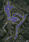
Current plan is 292ac with terrain following @ 250ft AGL. Obviously the final plan will have the marked area excluded. Whatya think?
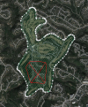
1652218099816.png
 
  • Like
Reactions: yarrr and jmason702
Hey Autel Peeps! I'm pretty new to the forum but have been survey-grade mapping for about 7 years now and just recently acquired the Evo II Enterprise (Pro w/ RTK module).

Short story is I run the VDC programs for a General Contractor and we have been asked to bid mapping the 300ac extents. I know what I would do but have yet to speak with the client so this is a good opportunity for some guidance. I am sure they have some intelligent idea of what they want to see from their facility and I am pretty what we do on a daily basis is going to cover 90% of it but wanted to see if anyone has done a golf course and if they had any oddities to watch out for.

Current plan is 292ac with terrain following @ 250ft AGL. Obviously the final plan will have the marked area excluded. Whatya think?

View attachment 14001
Go for it, i have been marketing the same thing here in Vegas, just started, Golfing is a BIG DEAL here!
 
  • Like
Reactions: elphtrooper
Hey Autel Peeps! I'm pretty new to the forum but have been survey-grade mapping for about 7 years now and just recently acquired the Evo II Enterprise (Pro w/ RTK module).

Short story is I run the VDC programs for a General Contractor and we have been asked to bid mapping the 300ac extents. I know what I would do but have yet to speak with the client so this is a good opportunity for some guidance. I am sure they have some intelligent idea of what they want to see from their facility and I am pretty what we do on a daily basis is going to cover 90% of it but wanted to see if anyone has done a golf course and if they had any oddities to watch out for.

Current plan is 292ac with terrain following @ 250ft AGL. Obviously the final plan will have the marked area excluded. Whatya think?

View attachment 14001
Looks like it's going to be a lot of flying considering the acreage and altitude you plan to fly at.
Please share how you want to aproach the job and how it eventually went.
Will it be RGB only or multispectral as well?
 
Looks like it's going to be a lot of flying considering the acreage and altitude you plan to fly at.
Please share how you want to aproach the job and how it eventually went.
Will it be RGB only or multispectral as well?
Our bid is photogrammetry with a DTM and Planimetrics. We are bidding against Lidar which does seem fair but when they see the cost they will have a different perspective.

Once I analyze the site I will be able to determine where launch points are and will probably split it into 3 sections. The area has a lot of relief so it may be more like 6 missions which would match the battery count and is probably the safest. It would be the most efficient from a data standpoint as well.
 
  • Like
Reactions: jmason702
Our bid is photogrammetry with a DTM and Planimetrics. We are bidding against Lidar which does seem fair but when they see the cost they will have a different perspective.

Once I analyze the site I will be able to determine where launch points are and will probably split it into 3 sections. The area has a lot of relief so it may be more like 6 missions which would match the battery count and is probably the safest. It would be the most efficient from a data standpoint as well.
Good luck and safe flying. Have fun.
Am curious to hear from you after the job.
 
Good morning of the 4th from Texas! The course has been flown and processed through DroneDeploy. With RMSE's around 1ft XY and 1.5ft Z I think this is acceptable for the size and odd spread of the holes. I used a trick I learned in DroneDeploy to get a nicely trimmed master ortho because there isn't the ability for an interior exclusion zone. I am now processing in SimActive Correlator 3D as a check. While this is processing I am DTM'ing the DroneDeploy DSM LAS. This is the first place outside of processing that we calibrate the elevations to the orthometric checkpoints. I section the point cloud so that I could control the point filtering to more common elevation but also to vegetation type and amount. Autel REALLY needs to build terrain awareness and linear flight! I had 11 different flights to cover this when I could have done in from three positions if those features were available.

The beginnings of planning. Beginning official ;) document, initial planning in Google Earth Pro which was verified with the client and the cut across and wrap inside trick in DroneDeploy.

1656947451908.png 1656947588594.png 1656948507373.png

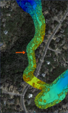
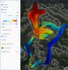
First rendition of the ortho and the DSM Z values. You can see the checkpoints and site elevation benchmark that were pulled from recent construction plans.

1656947859949.png 1656948032433.png

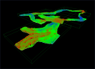
Carlson Precision 3D Topo DTM'ing. I'll use each checkpoint to calibrate each section. Sectioned DSM cleaned.

1656948750959.png 1656951067726.png

More updates to come!
 
  • Like
Reactions: Socketcreep
Can you explain this more if you don't mind?
For sure. You see how the back Nine goes south and is a continuous loop. Obviously I didn't want or need to fly over the subdivision so I took the perimeter which I was already doing manually because duh it's an Autel, but making the perimeter loop up into the void DroneDeploy wouldn't try to process across. Basically fooling the machine to think there was an exclusion. I'm not sure if it saved any time or not but I can always play with the data more once I get the deliverables out.
 
For sure. You see how the back Nine goes south and is a continuous loop. Obviously I didn't want or need to fly over the subdivision so I took the perimeter which I was already doing manually because duh it's an Autel, but making the perimeter loop up into the void DroneDeploy wouldn't try to process across. Basically fooling the machine to think there was an exclusion. I'm not sure if it saved any time or not but I can always play with the data more once I get the deliverables out.
NICE, any luck on getting DD to work with Autel in flying missions yet?
 
  • Like
Reactions: Socketcreep

Latest threads

Members online

Forum statistics

Threads
11,280
Messages
102,946
Members
9,877
Latest member
Wilson