

You are using an out of date browser. It may not display this or other websites correctly.
You should upgrade or use an alternative browser.
You should upgrade or use an alternative browser.
Failed to Start the Mission
- Thread starter elphtrooper
- Start date

What sucks about this is that DDE (Map Pilot) is more than happy to support the Enterprise model. It is our now old problem of Autel not caring what in the current SDK is not seeing the Enterprise craft. Kind of like how Autel ignores the problem with whatever is causing the failure with Emlid Local NTRIP. Both of these are most likely very tiny coding issues that could be fixed very quickly....if Autel wanted to. Very frustrating.
UGCS is so much more complicated and involved than Map Pilot or Drone Deploy.
I had conversations with a couple of people from map pilot when I was doing tests with the evo 2 enterprise and its app, I even offered my own evo 2 enterprise to be able to do the tests they needed with Map pilot since they did not have this model or the rtk module, I put their last answers....
There isn't anything you can do to help development other than verify that it is working without the RTK module on your firmware. You have provided the firmware version and we will try that at some point. To be honest Autel is pretty problematic as their SDK is super buggy. We worked for months to add support for them and we are lucky we even have something working. This is why very few other apps support them. The RTK models are even less prevalent which makes this probably an issue with the Autel SDK which is not something we have control over.
We may add support for it at some point if we come across an RTK module. Autel seems to be changing things with every firmware update so it is all a mess. We may have to start publishing firmware versions that are known to work.
These conversations were in December, and as far as I know it is not yet compatible
- Joined
- May 6, 2022
- Messages
- 176
- Reaction score
- 111
- Age
- 50
It amazes me how a company with this level of tech doesn't have better Engineering and support. Whoever is in control of customer service needs to be strapped to a drone and dropped in the middle of the Atlantic. The number one mistake they make is the lack of a complete beta stage. They should seriously take advatage of our experience. I can't even imagine how good this bird could be if they would target issues as defined by their users. They had their chance out of the factory and now it's our turn.I had conversations with a couple of people from map pilot when I was doing tests with the evo 2 enterprise and its app, I even offered my own evo 2 enterprise to be able to do the tests they needed with Map pilot since they did not have this model or the rtk module, I put their last answers....
There isn't anything you can do to help development other than verify that it is working without the RTK module on your firmware. You have provided the firmware version and we will try that at some point. To be honest Autel is pretty problematic as their SDK is super buggy. We worked for months to add support for them and we are lucky we even have something working. This is why very few other apps support them. The RTK models are even less prevalent which makes this probably an issue with the Autel SDK which is not something we have control over.
We may add support for it at some point if we come across an RTK module. Autel seems to be changing things with every firmware update so it is all a mess. We may have to start publishing firmware versions that are known to work.
These conversations were in December, and as far as I know it is not yet compatible
We are in contact and have a good path started so let's see if they are interested in beating DJI or not.
That said today's mission was an MF'er. I used 5 batteries and almost killed the Smart Controller on 40 acres! I will admit that it was a crosshatch but the Autel system ran it in about 60 minutes whereas the same spec'd mission with a Phantom 4 Pro would take 39 minutes on DroneDeploy.
185ft AGL
75/65 Overlaps
I'll post a more comprehensive journal of the day in a bit.
- Joined
- May 6, 2022
- Messages
- 176
- Reaction score
- 111
- Age
- 50
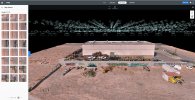
Check this out. Because of all the reboots look at the file structure on the mSD card... This is half of them and there is a second card. Let's see how long this takes.

***The answer is 25 minutes.
***The answer is 25 minutes.
Last edited:
WIRE - Google Drive
 drive.google.com
1113 photos in 4 files, what you have is not normal! WTF is going on with the Enterprise...


- Joined
- May 6, 2022
- Messages
- 176
- Reaction score
- 111
- Age
- 50
It's because I rebooted the SC and/or AC 20+ times and it created a new folder each time. It's really a battery swap workflow at fault.WIRE - Google Drive
1113 photos in 4 files, what you have is not normal! WTF is going on with the Enterprise...
- Joined
- May 6, 2022
- Messages
- 176
- Reaction score
- 111
- Age
- 50

Don't reboot the SCIt's because I rebooted the SC and/or AC 20+ times and it created a new folder each time. It's really a battery swap workflow at fault.
- Joined
- May 6, 2022
- Messages
- 176
- Reaction score
- 111
- Age
- 50
An Android force stop was the only thing that would get me to a point where it would get past an uploading mission loop. It tries to connect to the drone and start the mission before you even have the ability to reconnect NTRIP. That's the root of that problem.Don't reboot the SC
WOWAn Android force stop was the only thing that would get me to a point where it would get past an uploading mission loop. It tries to connect to the drone and start the mission before you even have the ability to reconnect NTRIP. That's the root of that problem.
¿Has comprobado que no se repite la numeración de las fotos en varias carpetas?Mira esto. Debido a todos los reinicios, mire la estructura de archivos en la tarjeta mSD... Esta es la mitad de ellos y hay una segunda tarjeta. Veamos cuánto tarda esto.
View attachment 14055
***La respuesta es 25 minutos.
reynolds8126
Active Member
- Joined
- Jan 6, 2022
- Messages
- 32
- Reaction score
- 27
- Age
- 51
Quite a bit to digest on your post. I will comment on your item 7 only.can you specify the firmware that you use in the enterprise with the RTK module?, like many, I am having countless problems when using this drone in photogrammetry, I have already reported a lot of failures to autel china but it is like talking to a wall . Luckily Ken a week ago gave me an older firmware and an older app, WiMaxPad_FW_V2.2.5.zip, is it the same one you are using? I am going to leave here the problems / suggestions that I communicate to them in the wechat support group.
all this was reported in February
1. Improve the support service, we have been claiming some antennas for a smart controller v2 for 4 months that fell after only 1 hour of use. I know you're on it, but you must do it faster
2. When there is a problem with the rtk service provider and the drone loses the FIX state in the RTK connection, the main screen still shows FIX, but if you enter the RTK configuration, you can see how it is disconnected, for some reason. For this reason, the connection status is not updated on the main screen.
3. It would be a good idea if you included the option to save several connection profiles to different RTK service providers, currently every time you move to another city, or even in the same city but changing provider, you have to delete your data from provider of the RTK service of the last flight and put the new ones, if you included a kind of profile store it would be great, it would be a little faster for the client.
4. Include more flight modes and utilities for photogrammetry, such as linear mission or Terrain awearness
5. Using the smart controller (I don't know if it happens with the standard remote control too), when doing a waypoints mission imported in kml, when it loses radio signal and recovers it again, you have control of the drone through the transmitter, but the app does not respond to any instructions, you see the camera image in the small square of the app, but on the main screen you see the loading icon, and it may take 5 or 10 minutes for the app to link again with the drone, sometimes the mission ends and the app is still not linked correctly. When this happens, it seems that the mission remains unfinished and if you try to start that mission again, when launching the mission in the app it appears as if it was doing the mission, but the drone has not even taken off.
6. Eliminate the pauses at each point of the waypoint, currently, in missions by waypoint, the drone stops to perform the action, this in photogrammetry is a significant waste of time, the drone stops even if you have the FLYOVER option checked in the waypoint mission.
7. Currently to receive the differential corrections for the RTK you depend on having telephone coverage and data connection so that through the Wi-Fi shared by your phone for example, the smart controller receives those corrections, you can also use your own gps station to send the corrections also through the internet. But there is another way, and that is that your own GPS station sends the differential corrections directly via Wi-Fi, without the need to have telephone coverage or a data connection, by connecting the smart controller to the Wi-Fi of the GPS station, well, this option does not work , this option is necessary in environments where there is no mobile phone coverage.
8.Problems with file numbering, the same numbering is repeated in different folders on different flights on the same day, it does so randomly and does not continue with the numbering of the previous folder, making those photos unable to be dragged into the program since they already They exist under that name.
9. the drone is doing a mission, it is on its way correctly, but on the screen it shows the wrong position, it is jumping from the position in which it is to another in which the drone is not
10. During the waypoint mission, when it reaches a point, the camera goes to 0º and goes down again to -90º, leaving that photo completely useless.
11. Randomly, the mission duration information becomes ascending instead of descending, ie the time is increasing instead of decreasing. And this does it well sometimes and other times it changes in the middle of the mission.
and from the latest firmware...
the few things that worked well have stopped working, in the imported KML missions. 4 out of 5 fail, the mission starts and at the third or fourth point it shows the mission finished message, and the worst thing is not only that, it is that the drone remains standing there without saying anything else, or going home or anything.
It does not generate RINEX files, since the last firmware it has stopped doing it.
loss of photos during the mission
sometimes it doesn't fly along the mission line but along a parallel line
and nothing mentioned in February has been solved, how are you dealing with these problems? They have a great machine but the software leaves a lot to be desired and this is costing us money. The response from autel is null, so as always we only have users to support each other, so everything in my power to help, count on me.
We have been successfully receiving corrections from a local base station over WiFi and without any cellular connection, using Trimble GNSS receivers. I recognize most users don't have Trimble survey grade receivers; however, that is the equipment we are using. I suspect one simply needs a device that serves as the NTRIP caster.
The Trimble receivers we use only provide the option to be the caster. We simply connect to the WiFi network, broadcast from the receiver, and enter the login credentials (IP, Port, User Name, and Password) from the caster configuration page of the receiver's web UI and we successfully receive the corrections.

- Joined
- May 6, 2022
- Messages
- 176
- Reaction score
- 111
- Age
- 50
Quite a bit to digest on your post. I will comment on your item 7 only.
We have been successfully receiving corrections from a local base station over WiFi and without any cellular connection, using Trimble GNSS receivers. I recognize most users don't have Trimble survey grade receivers; however, that is the equipment we are using. I suspect one simply needs a device that serves as the NTRIP caster.
The Trimble receivers we use only provide the option to be the caster. We simply connect to the WiFi network, broadcast from the receiver, and enter the login credentials (IP, Port, User Name, and Password) from the caster configuration page of the receiver's web UI and we successfully receive the corrections.
If you have a local base what do you need NTRIP corrections for? Most modern receivers have to ability to do offline casting including Emlid which I believe is what @cegio was getting at.
reynolds8126
Active Member
- Joined
- Jan 6, 2022
- Messages
- 32
- Reaction score
- 27
- Age
- 51
For clarification, since I am using a local base and simply broadcasting the corrections from the base to the Evo via WiFi, I am simply receiving a RTCM output from the receiver. Technically, I am not using NTRIP as the data is not transferred via the internet. The Trimble receiver's web UI refers to the I/O type as NTRIP Caster. That is why I used the terminology that I did.If you have a local base what do you need NTRIP corrections for? Most modern receivers have to ability to do offline casting including Emlid which I believe is what @cegio was getting at.
Regardless, my point is that we have had success with the local broadcast over WiFi for RTK mapping projects. I understood @cegio stated this option does not work. I described our setup simply to address the opinion that this option does not work.
- Joined
- May 6, 2022
- Messages
- 176
- Reaction score
- 111
- Age
- 50
I think the term WiFi is what is confusing me. If you have a local base you send UHF/VHF radio to a rover. With a drone you cannot use that VHF signal directly like you can with the D-RTK 2 which is the same then as a standard site surveying setup. When I think WiFi it's either to a device's onboard hotspot or a device is transmitting data over WiFi as with a traditional hotspot or MiFi. Can you clarify your use of the term WiFi? How are you correcting directly to the Evo with a Trimble device? Local NTRIP?For clarification, since I am using a local base and simply broadcasting the corrections from the base to the Evo via WiFi, I am simply receiving a RTCM output from the receiver. Technically, I am not using NTRIP as the data is not transferred via the internet. The Trimble receiver's web UI refers to the I/O type as NTRIP Caster. That is why I used the terminology that I did.
Regardless, my point is that we have had success with the local broadcast over WiFi for RTK mapping projects. I understood @cegio stated this option does not work. I described our setup simply to address the opinion that this option does not work.
I imagine that he refers to connecting to the Wi-Fi network that the trimble emits with the smartcontroller to receive the corrections in the app.I think the term WiFi is what is confusing me. If you have a local base you send UHF/VHF radio to a rover. With a drone you cannot use that VHF signal directly like you can with the D-RTK 2 which is the same then as a standard site surveying setup. When I think WiFi it's either to a device's onboard hotspot or a device is transmitting data over WiFi as with a traditional hotspot or MiFi. Can you clarify your use of the term WiFi? How are you correcting directly to the Evo with a Trimble device? Local NTRIP?
Similar threads
- Replies
- 12
- Views
- 4K
- Replies
- 17
- Views
- 1K


Latest threads
-
We need your Autel evo 2 V1 6K rugged bundle.
- Started by Autel-euducational
- Replies: 0
-
Questions on original Evo 1 and the new app Autel Sky
- Started by jaja6009
- Replies: 0
-
-