Welcome, Autel Pilots!
Join our free Autel drone community today!
Join Us

Converting GEO TIFFs to DXF Files for CAD

Long story short on your original question, there is no program available right now that will automatically take raster (or point cloud) UAV data and extract usable vector data of objects.
I spoke with a Carlson regional rep, and he said that the automation of identifying and extracting CAD from features in point cloud data is the "holy grail", his words, in the 3d CAD software world right now.
 
  • Like
Reactions: yarrr
Carlson Photo Capture like Pix4d will give you a good georeferenced final orthomosaic image as well as digital terrain models. Especially if you are using RTK drone with GCPs, the final ortho is pretty good and comes in directly in the proper x,y space in the cad file.
Metashape is also excellent for processing and exporting point cloud data, either raster or vector. In the video you posted, Metashape was the processor.
 
Last edited:
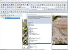
Here is the same area in the point cloud. This is a screen shot but the actual point cloud is a 3d model that I can easily move around with simple mouse clicks.
That is a good example, thanks for the share. Do you have links for the other vids in the series?

He does not identify the software he uses initially before moving to to Civil 3D?

He also gave this link to actually try the software with his mission loaded.


Attachments

  • AB Layout1_example_pointcloud_crop.pdf
    607.9 KB · Views: 3
For example, I'm flying a huge rooftop of a building, where many pipes and duct work, and AHUs will be installed. I want to, need to give them a file that they can use in Navis or Revit, or auto CAD. So they can draw in all the Piping, Ductwork, etc...
The best file type would be Ortho or Point Cloud for this need?
And since they never have worked with aerials, what can I do to help them?

Thanks again, your input is much appreciated

Depends if they're trying to do 2D or 3D layouts. If we're talking Navis & Revit, it seems likely that they're going to want 3D. AutoCAD could go either way. If they want to do 3D, then a point cloud is the way to do it.

BUT...

If they're trying to bring a point cloud into Navis / Revit / AutoCAD / anything else Autodesk, then it needs to be in .RCP format, which is output from Recap.

I'm not sure if the free version of Recap (I have a subscription to Pro) will allow you to import, say, an .e57 and then save it as .RCP, but I do know that you're limited on your editing capabilities with it. You can, however, download the trial version of Recap Pro and then for the next 30 days have access to the full import-export-edit tools before it converts to the regular free version.

One word of caution about Recap: depending on how the data was created, it may or may not like WGS84 point clouds. It's something to do with whether the coordinates were stored in decimal or degrees, but I can't remember which one it wants- I only remember that Metashape outputs the wrong one, so I have to tell it to output in NAD27 / NAD83 instead.
 
  • Like
Reactions: yarrr
I spoke with a Carlson regional rep, and he said that the automation of identifying and extracting CAD from features in point cloud data is the "holy grail", his words, in the 3d CAD software world right now.
No truer words. I have been following the development of the "in between" software for some time. Terrestrial laser scanning has been around for a while, including Carlson's Point Cloud. You can find 9 yr. old videos on their YouTube channel. But it has always been tedious mining and drafting data from the cloud. We jumped into the drone game only recently since the development of RTK drones. I am still into the middle of the learning curve, but the nice thing about having the point cloud and the ortho mosaic is the data is always there for future mining of the site. It has been extremely handy since our first snowfall in the NE as the big site we are working on and was flown in Oct. is available to find missing structures and ground data.

Check out the Virtual Surveyor site and their videos. They seem to be ahead of the curve in extracting data. We might add that to our arsenal of software products as we get better at this.

 
Thats beyond my pay scale! Nice work

Thanks. It's just a matter of spending some time learning software, really. I went from being a temp draftsman to being a senior mechanical engineer mostly by means of "well, WTF am I supposed to do with this? Guess I have to figure it out."
 
  • Like
Reactions: yarrr
Here is the same area in the point cloud. This is a screen shot but the actual point cloud is a 3d model that I can easily move around with simple mouse clicks.


He also gave this link to actually try the software with his mission loaded.

Thanks. It doesn't look like there is any way to actually use the software. Perhaps it is just an in-house project.
 
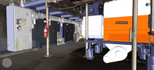
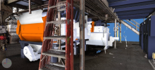
That's why you don't mine data from the cloud... you work inside of it.

View attachment 15284
View attachment 15283

Cool! And with interiors there is no pesky coordinate systems to deal with right? How do you establish control in environments like that, measured distances in all axes? Metashape calls them scalebars but I don't know if that terminology is used in other applications.
 
Cool! And with interiors there is no pesky coordinate systems to deal with right? How do you establish control in environments like that, measured distances in all axes? Metashape calls them scalebars but I don't know if that terminology is used in other applications.

Oh, you still have coordinate systems, it's just that they're based around the real-world environment that you're using. This is a Recap cloud, so Z is up and Y=true north. In this case, the real-world is kinked a few degrees off NSEW alignment, and the ground isn't flat, so I set the XY plane at a fairly arbitrary height.

Also, because everything is done based off the georeferenced point cloud, there's no issues with scale, or with metric vs imperial- none of that matters in the slightest. Just work at full scale, with whatever parts you have laying around, and it all comes together.

The actual work was done in Autodesk Inventor, with sections of the cloud imported to that with cloud origin set to assembly origin, and the modeling was done from that frame of reference. Subsequently, the cloud and the Inventor assemblies were loaded into Navisworks and, since all the origin points were the same, everything lined up there the way it does in software. (And, coincidentally, everything looks like it's going to fit in the real world as well. This is from one of my current projects.)
 
So in my case, being the Data Collector and passing on aerial Point Clouds to an MEP BIM company. RECAP would be a good starting point to convert the file types to their needs.

Thoughts??
 
Here is the same area in the point cloud. This is a screen shot but the actual point cloud is a 3d model that I can easily move around with simple mouse clicks.


He also gave this link to actually try the software with his mission loaded.

That looks like WEB ODM ?
 
So in my case, being the Data Collector and passing on aerial Point Clouds to an MEP BIM company. RECAP would be a good starting point to convert the file types to their needs.

Thoughts??
Never caught what program you were using for post processing.

If your contract is just for Data Collection, can't you just hand then the LAS file? That's an easy output from Pix4d/Metashape/Webodm.
 
Never caught what program you were using for post processing.

If your contract is just for Data Collection, can't you just hand then the LAS file? That's an easy output from Pix4d/Metashape/Webodm.
I mostly use DD, and some of the BIM departments come back to me that they don't know the file type, or that we need it in the RCP file type. RECAP seems an affordable solution, and from what I read about it, it seems it can do these things and more, I got the trial package and I was able to import a LAS point cloud and export it as an RCP point cloud. Also says it can stitch up to 1000 photos into a model, but you have to subscribe for that. it's like $360 a year.

One company I'm working with has never processed or used aerials, They work with laser scans that come to them as an RCP file type.
I was on the rooftop with the laser scanner guy, took him all day to scan a not-so-big commercial roof, moving 25 ft at a time. I could have done it with my RTK drone and set points in 45 min. His cost was 8K for the scans

I would also like to learn more about how the aerials are used in CAD and BIM, but can't afford all the Autodesk family software, also the time and training involved. so looking for a starting point.

Someday I would like to get into on-the-ground laser scanning, so you can scan the inside of buildings/structures. The scanners that produce survey-grade are anywhere from 60K to 80K
 
  • Like
Reactions: yarrr
I mostly use DD, and some of the BIM departments come back to me that they don't know the file type, or that we need it in the RCP file type. RECAP seems an affordable solution, and from what I read about it, it seems it can do these things and more, I got the trial package and I was able to import a LAS point cloud and export it as an RCP point cloud. Also says it can stitch up to 1000 photos into a model, but you have to subscribe for that. it's like $360 a year.

One company I'm working with has never processed or used aerials, They work with laser scans that come to them as an RCP file type.
I was on the rooftop with the laser scanner guy, took him all day to scan a not-so-big commercial roof, moving 25 ft at a time. I could have done it with my RTK drone and set points in 45 min. His cost was 8K for the scans

I would also like to learn more about how the aerials are used in CAD and BIM, but can't afford all the Autodesk family software, also the time and training involved. so looking for a starting point.

Someday I would like to get into on-the-ground laser scanning, so you can scan the inside of buildings/structures. The scanners that produce survey-grade are anywhere from 60K to 80K


First, with respect to Recap: there's two different things that get installed. Recap/Recap Pro (depending on trial or subscription) is for working with point clouds. Recap Photo is the thing for doing photogrammetry, and that one is based on cloud credits. Unfortunately it's really pretty worthless. The output that it gives you is not even remotely worth the money you'll spend on cloud credits. Sometime when I have a chance I'll set up a side-by-side-by-side with Metashape Pro vs WebODM vs Recap Photo. It's really kind of shocking what you spend in cloud credits vs what you get back with Recap Photo.

As far as the workflows and how things are used, I'd be more than happy to walk you through some of it on Teams or Discord or something. I'm pretty sure I've got licenses for just about everything relevant, and I've been looking for an excuse to play with some of the more esoteric stuff. This week probably isn't going to work, but during the week between Christmas and New Years I should have some time available if you're interested. (Or anyone else, for that matter.)
 
  • Like
Reactions: jmason702 and yarrr
First, with respect to Recap: there's two different things that get installed. Recap/Recap Pro (depending on trial or subscription) is for working with point clouds. Recap Photo is the thing for doing photogrammetry, and that one is based on cloud credits. Unfortunately it's really pretty worthless. The output that it gives you is not even remotely worth the money you'll spend on cloud credits. Sometime when I have a chance I'll set up a side-by-side-by-side with Metashape Pro vs WebODM vs Recap Photo. It's really kind of shocking what you spend in cloud credits vs what you get back with Recap Photo.

As far as the workflows and how things are used, I'd be more than happy to walk you through some of it on Teams or Discord or something. I'm pretty sure I've got licenses for just about everything relevant, and I've been looking for an excuse to play with some of the more esoteric stuff. This week probably isn't going to work, but during the week between Christmas and New Years I should have some time available if you're interested. (Or anyone else, for that matter.)
Very Cool, I will hit you up, Thanks
 

Latest threads

Members online

Forum statistics

Threads
11,289
Messages
103,011
Members
9,899
Latest member
rudymuller