You are using an out of date browser. It may not display this or other websites correctly.
You should upgrade or use an alternative browser.
You should upgrade or use an alternative browser.
Autel Evo Altitude not correct!!
- Thread starter resq3129
- Start date
waltermitty
Well-Known Member
If you have 20 satellite locks and their relative positions in the sky were broad and horizon to horizon, then altitude should have been reasonablly accurate since that data point is based on simple satellite distance/time signal calcuation. So I don't understand why the error would be so high.
Prevailing unusual atmospheric conditions may also affect GPS accuracy, most noteably solar flare... and to a much lesser degree, local wx conditions.
(disclaimer: written by a newbie drone pilot)
Prevailing unusual atmospheric conditions may also affect GPS accuracy, most noteably solar flare... and to a much lesser degree, local wx conditions.
(disclaimer: written by a newbie drone pilot)
Did you try downloading the google maps for offline use to compare ? We noticed a sim issue with E1 last year, and it was the maps used. Updated the maps, and the error corrected. Not sure what else to tell you. Any others near you with an E2 that you can compare? Our company ordered 4 E2P's and we love them. They are replacing our old E1 fleet.
Thanks for these instructions. I just had a look in the manual about updating the Google maps but can't find out how to do this. Your advice welcome.
When you say it was a 'sim' issue what does that refer to please?
Thanks
When you say it was a 'sim' issue what does that refer to please?
Thanks
Hi
I just had another experience with this. This time a shade over 6m out. I never ever had this problem with my Mavic Air.
There is something seriously wrong. 15 satellites. How do I download the flight data to send into Autel?
I just had another experience with this. This time a shade over 6m out. I never ever had this problem with my Mavic Air.
There is something seriously wrong. 15 satellites. How do I download the flight data to send into Autel?
I have a 4-month-old Evo2 8k, same issue. I just sent it back, they replaced the ICU, and its still the same.
For me, I can fly for 5 mins under 20 feet and it will eventually show me Negative altitude. I can hover at what looks like 10 feet and it says it's at 4 feet on the readout. This is scary for mission flying.
I wrote back and they said have you calibrated it.. I want to scream at him.. You just sent it back to me, surely you tested and calibrated it after replacing ICU.. uuuuuggghhh..!
How can we use a bird for mission flying that doesn't know its correct altitude..
I agree with you. My drone is for recreation not for commercial use where, I would assume, detail is important. I just run the risk of ditching my drone and losing my hard earned pennies. Lets see what Autel says about my issue. I have to say that the lack of capacity to download a flight log and all its detail does not fill me with confidence. Using a phone screen recording device to record the flight log would seem to miss a lot of detail, detail which my old Mavic Air could provide. I shall reserve judgement until I see what the outcome is.
AdamJ1555
Well-Known Member
I found the same yesterday while flying an E2P and E2D. Both were off by 7-10 feet after minimal flying.
Jsizzle*EVO*1_Alpha
Well-Known Member
A quick question and I'm sorry if this has already been explained or gone over... But what flight mode are you flying in? Are you using the mission planning to capture these expeditions or are you just going up in a manual mode and taking the pictures as you normally would? If in manual mode I have experienced that you need to broadcast the GPS coordinates along with the intermittent pictures to be taken as you fly without any real user input, but if you are using the mission planner as you should be using it then I don't really know considering you could have a simple setting misconfigured which I know sounds stupid but trust me it happens to the best of us.Yes it is an Autel is trying to tell me that it isnt! They will check it out if i ship it to them and pay the costs of shipping it to them and them shipping it back to me, oh and paying them to diagnose it. This particular drone was given to me as a gift and the person who purchased it has passed away and nobody knows where it was purchased from or when. I received it in November of 2019! Not very happy with Autel right now!!
Hi, were you flying above or below your take-off point?I found the same yesterday while flying an E2P and E2D. Both were off by 7-10 feet after minimal flying.
Flying in Manual mode taking pictures both manually and with drone set to take pictures every 2 seconds depending on mission.A quick question and I'm sorry if this has already been explained or gone over... But what flight mode are you flying in? Are you using the mission planning to capture these expeditions or are you just going up in a manual mode and taking the pictures as you normally would? If in manual mode I have experienced that you need to broadcast the GPS coordinates along with the intermittent pictures to be taken as you fly without any real user input, but if you are using the mission planner as you should be using it then I don't really know considering you could have a simple setting misconfigured which I know sounds stupid but trust me it happens to the best of us.
verticalflyer
Well-Known Member
- Joined
- Oct 26, 2020
- Messages
- 156
- Reaction score
- 85
I was curious and looked through some recent photos from my evo 2 and compared them to my flight screen recordings. BTW, you should not only be taking photos and video with the physical drone but you should also be recording your flight display while on a job (phone, tablet or live deck output). It helps with any liability and support issues.
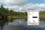
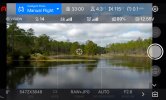
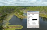
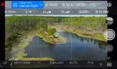
From looking at the below info I can say that, yeah, there's a pretty good discrepancy between what's recorded to exif to the images taken on the drone and what is shown on the flight display. The two sets of pics, one from the drone and one from my display, shows there's some problems.
I did spend a good amount of time this morning updating Explorer to 1.7.5 and going through the new features, updating the drone firmware to 2.5.11, all of the batteries and recording the maintenance in my logs so I haven't had a chance to test updates yet. The new IMU calibration setting could help with this but If a test this week doesn't resolve the issue then I'll be following up with Autel. 12 feet isn't all that far off I guess but it's noticeable but only if exif is recorded in meters and not feet.
If you had or have that many drones on order from a supplier, then maybe you should reach out to them to discuss your problem because if they are an authorized dealer then maybe they would reach out to Autel on your behalf just so they don't lose your sale. Outside of, on the drone you're seeing these issues with at the moment, if you can't provide purchase details then I really can't blame them for saying that they'll help you but possibly not under warranty.
Hover:


At Height:


From looking at the below info I can say that, yeah, there's a pretty good discrepancy between what's recorded to exif to the images taken on the drone and what is shown on the flight display. The two sets of pics, one from the drone and one from my display, shows there's some problems.
I did spend a good amount of time this morning updating Explorer to 1.7.5 and going through the new features, updating the drone firmware to 2.5.11, all of the batteries and recording the maintenance in my logs so I haven't had a chance to test updates yet. The new IMU calibration setting could help with this but If a test this week doesn't resolve the issue then I'll be following up with Autel. 12 feet isn't all that far off I guess but it's noticeable but only if exif is recorded in meters and not feet.
If you had or have that many drones on order from a supplier, then maybe you should reach out to them to discuss your problem because if they are an authorized dealer then maybe they would reach out to Autel on your behalf just so they don't lose your sale. Outside of, on the drone you're seeing these issues with at the moment, if you can't provide purchase details then I really can't blame them for saying that they'll help you but possibly not under warranty.
Hover:


At Height:


Last edited:
I cancelled the order since it was through Autel directly not a supplier. their loss not mine. I guess they can afford to loose that much money. I am also doing the update and waiting for decent weather here to try it out and send more info to them.I was curious and looked through some recent photos from my evo 2 and compared them to my flight screen recordings. BTW, you should not only be taking photos and video with the physical drone but you should also be recording your flight display while on a job (phone, tablet or live deck output). It helps with any liability and support issues.
From looking at the below info I can say that, yeah, there's a pretty good discrepancy between what's recorded to exif to the images taken on the drone and what is shown on the flight display. The two sets of pics, one from the drone and one from my display, shows there's some problems.
I did spend a good amount of time this morning updating Explorer to 1.7.5 and going through the new features, updating the drone firmware to 2.5.11, all of the batteries and recording the maintenance in my logs so I haven't had a chance to test updates yet. The new IMU calibration setting could help with this but If a test this week doesn't resolve the issue then I'll be following up with Autel. 12 feet isn't all that far off I guess but it's noticeable but only if exif is recorded in meters and not feet.
If you had or have that many drones on order from a supplier, then maybe you should reach out to them to discuss your problem because if they are an authorized dealer then maybe they would reach out to Autel on your behalf just so they don't lose your sale. Outside of, on the drone you're seeing these issues with at the moment, if you can't provide purchase details then I really can't blame them for saying that they'll help you but possibly not under warranty.
Hover:
View attachment 8862View attachment 8863
At Height:
View attachment 8864View attachment 8865
In some ways I am heartened to read this as I sometimes feel that the observations of pilots are not taken seriously. I have been in regular contact with Autel and been following their instructions and I am letting this process play out. However, as a recreational flyer, for whom an Autel Evo Pro is a significant investment, I am hesitant to fly my drone in the way/places that exposed what in my view are problems. If I lose my drone, that is the end of my investment in this activity. Am not sure how to solve this as outsourcing the risk to owners is not viable.
When you disconnect the app and device, and use just the display on the Evo what are the altitudes showing. Is it showing correct altitude on the devices, but not in the captured media? Or both? Did you test older versions of the app?
House Forasken
Well-Known Member
- Joined
- Mar 11, 2020
- Messages
- 158
- Reaction score
- 58
- Age
- 44
I too have the found the same issue. The altitude the drone displays (which I believe to be accurate) is not the same as what is showing on the JPEG details. I checked back through several photos taken on older versions of the software and none of the JPEG details correctly reflect the altitude the photo was taken at.
This is not a huge deal for me, I just wanted to state that this is an issue I'm observing also.
This is not a huge deal for me, I just wanted to state that this is an issue I'm observing also.
John Hennessy
Well-Known Member
- Joined
- Sep 6, 2020
- Messages
- 51
- Reaction score
- 31
- Age
- 68
Hi All,
I am a member in several forums for different manufactured uav's. The HEIGHT DISPLAY is JUST THAT a DISPLAY. The barometer on most of the sub $5K uavs are cheaply manufactured barometers. If you want accuracy you have to go to three sphere positioning with GPS or commonly known as the RTK system. The barometer varies with wind gusts of air that could be cold or warmer thus giving you a different Hts above take off point. They are far more accurate than 8 or 10 years ago. If you want precision you have to pay for RTK SYSTEM and all of it station costs as well, similar to a surveyor. I am sorry but that is the nature of the BEAST. But what a great BEAST it is. Johnno Hennessy.
Keep flying on the green side of the grass.
Checked this on Evo E2P. It's pretty much the same thing. Accuracy on altitude as indicated in photo details is off, though the altitude of the drone displays fine on the controller. My guess is it may be based on barometer data which these drone barometers are not very accurate.
verticalflyer
Well-Known Member
- Joined
- Oct 26, 2020
- Messages
- 156
- Reaction score
- 85
But the thing is that the altitude display on the controller is being reported back to the controller from the drone and should be from the same barometer that is being used to save EXIF data to pictures.
I looked into the EXIF standard and, per the actual standard, EXIF Altitude is logged as Meters and not Feet but as with all standards, they are just that.
I looked into the EXIF standard and, per the actual standard, EXIF Altitude is logged as Meters and not Feet but as with all standards, they are just that.
Similar threads
- Replies
- 3
- Views
- 339
- Replies
- 0
- Views
- 326
- Replies
- 1
- Views
- 757
- Replies
- 10
- Views
- 738
- Replies
- 2
- Views
- 828
Latest threads
-
-
-
-
Seeking Recommendations for Custom Voiceover Solutions
- Started by nobes
- Replies: 1
-
We need your Autel evo 2 V1 6K rugged bundle.
- Started by Autel-euducational
- Replies: 1


