

You are using an out of date browser. It may not display this or other websites correctly.
You should upgrade or use an alternative browser.
You should upgrade or use an alternative browser.
640T and Thermoconverter.
- Thread starter jmason702
- Start date
Thermocoverter won't read the already converted files, so I can do the IRG files from 640T and covert to TIFF

file size is larger than the TIFF straight out of EVO, not sure if this is going to help though
 drive.google.com
640T IRG to TIFF - Google Drive
drive.google.com
ChristianH
Active Member
TIFF was listed as an output option so it's good to know it is only from standard inputs.Thermocoverter won't read the already converted files, so I can do the IRG files from 640T and covert to TIFF
I processed this in Drone Deploy Enterprise.
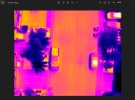
I checked an image and compared it to the temps in the ortho and it was pretty close. I do not have time right now to do a more in depth analysis.

Spot 1 on the truck is 122.12* F in Drone Deploy
Spot 2 on the car is 172.41 * F in Drone Deploy
I think a large part of this is because of the spot meter on FLIR Tools being a number of pixels while Drone Deploy is using just the point at the bottom of the inverted tear drop.
And tell your one neighbor he has a string of cells out in his one panel.
I checked an image and compared it to the temps in the ortho and it was pretty close. I do not have time right now to do a more in depth analysis.
Spot 1 on the truck is 122.12* F in Drone Deploy
Spot 2 on the car is 172.41 * F in Drone Deploy
I think a large part of this is because of the spot meter on FLIR Tools being a number of pixels while Drone Deploy is using just the point at the bottom of the inverted tear drop.
And tell your one neighbor he has a string of cells out in his one panel.
So in my opinion after more research, The outputs we can now get from the 640T and the benefits
640x512 JPegs (used to produce the cleanest looking nonradiometric photos and maps) (If the client wants the best looking easy to see detail, thermal map, or image this is the best I have seen, also contains more metadata)
640x512 R-JPegs (used in FLIR Tools and used in R-Jpegs compatible mapping software)
TIFFs (used in Metashape and others and always good to have)
IRG (used in the IR-PC Tool, and now can be converted to FLIR R-Jpegs)

I will as soon as I can. My Mavic 2 Enterprise Advanced is being replaced by DJI Care. I will be have it in about 2 weeks.If anyone can share a DJI Proprietary output for comparison please do...
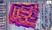
Ok I received my replacement Mavic 2 Enterprise Advanced and here is the output in Drone Deploy Enterprise.
 www.dronedeploy.com
Unfortunately I did not do 90/90 overlap. It was 85/80. But I will run another test soon and do it in a matching color palette as these other tests.
Also I ran the TIFFs from the Evo 640T in Metashape. Using the Raster Transform formula and there was a problem with the temperature values. They were not correct. Can someone tell me more about the formula, if I can understand it, I might be able to correct it.
DroneDeploy
www.dronedeploy.com
Unfortunately I did not do 90/90 overlap. It was 85/80. But I will run another test soon and do it in a matching color palette as these other tests.
Also I ran the TIFFs from the Evo 640T in Metashape. Using the Raster Transform formula and there was a problem with the temperature values. They were not correct. Can someone tell me more about the formula, if I can understand it, I might be able to correct it.
I normally do 80/80 overlap and seem to have zero issues...Ok I received my replacement Mavic 2 Enterprise Advanced and here is the output in Drone Deploy Enterprise.
DroneDeploy
Unfortunately I did not do 90/90 overlap. It was 85/80. But I will run another test soon and do it in a matching color palette as these other tests.
Also I ran the TIFFs from the Evo 640T in Metashape. Using the Raster Transform formula and there was a problem with the temperature values. They were not correct. Can someone tell me more about the formula, if I can understand it, I might be able to correct it.
Also, the EVO maps seem so much more sharp and crisp looking any idea why?
TIFFs I have no clue about how to use them in meta shape.
Attachments
ChristianH
Active Member
I did a crude comparison of pixel temperature values in the IR PC Tool program and the TIFF raw values. I inspected images from @jmason702 as well as some from my own 640T sensor and both ended up plotting along the same regression line of y=0.0991x-270.18. Granted that these points were from "eyeballing" locations on the JPEG/IRGs and TIFFs --> I modified the equation to y=0.100x-273.15 and recalculated the TIFF values in temperature ('y=mx+b' column). Ignore the "converted TIFF" column.Ok I received my replacement Mavic 2 Enterprise Advanced and here is the output in Drone Deploy Enterprise.
DroneDeploy
Unfortunately I did not do 90/90 overlap. It was 85/80. But I will run another test soon and do it in a matching color palette as these other tests.
Also I ran the TIFFs from the Evo 640T in Metashape. Using the Raster Transform formula and there was a problem with the temperature values. They were not correct. Can someone tell me more about the formula, if I can understand it, I might be able to correct it.
For a quick and dirty test, I feel confident that we can accurately determine the conversion equation by either using the exact pixel locations or analyzing many images using the max, min, and median values. I suspect it will be close to the second equation since the y-intercept is absolute zero (-273.15 C) and probably not a coincidence.
In Metashape, try the above modified conversion equation in the raster transform dialog box.
Cheers,
Christian
Attachments

Last edited:
CW3Drones
Member
- Joined
- Sep 18, 2021
- Messages
- 20
- Reaction score
- 11
- Age
- 62
- Location
- Kansas City, MO
- Website
- cw3drones.wixsite.com
 As a noob to Autel II Dual 640t V2, I was thrilled to finally get the Autel IRPCTOOL 1.3.3. I’ve only been flying the thermal for a couple of months and since it doesn’t come with any useful manual specific to the 640t, I’ve been learning through trial and error, FLIR articles, and YouTube.
I’ve began putting together a QuickStart guide for the IRPCTOOL based on what I’ve discovered so far, and would welcome the advice or learned experiences from others willing to share.
I’m doing some simple screenshots with comments and I’d be happy to share with anyone in the group that’s interested. I don’t know that it would be of much interest or benefit beyond Autel dual 640t users, and perhaps less so to seasoned experts.
That said, if you’re interested in contributing or collaborating DM me. If this isn’t the right place to post this topic, I don’t want to clutter this thread with off topic messages.
Thanks.
Eugene
[email protected]
————UPDATE (Finally)———
After several months of tweaking and weeks of research and writing, I finally finished my (unofficial) Autel IRPCTOOLS QuickStart Guide (https://a.co/d/gSVUW3g) You can download and read it for free with Kindle Unlimited on Amazon! I included screenshots, descriptions, and a couple of supplemental appendices. Check it out, share it with your network, as well as your honest feedback. I don’t have thin skin and if I didn’t hit the mark, it’d be good to know. It’s kindle, so I can update it if necessary.
Anyways, I want to give a shout out to Capt Avery, Platte County Sheriff’s Office, Missouri for his encouragement to create this guide.
-
EM
Last edited:
Hola,la 640T es una herramienta poderosa, y más aún ahora podemos usar FLIR Tools
me puedes explicar como conseguir eso...?
Thank you ...
Similar threads
- Replies
- 0
- Views
- 387
- Replies
- 3
- Views
- 1K
- Replies
- 0
- Views
- 663
- Replies
- 1
- Views
- 1K


Latest threads
-
-
-
Seeking Recommendations for Custom Voiceover Solutions
- Started by nobes
- Replies: 1
-
We need your Autel evo 2 V1 6K rugged bundle.
- Started by Autel-euducational
- Replies: 1
-
Questions on original Evo 1 and the new app Autel Sky
- Started by jaja6009
- Replies: 0