

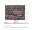
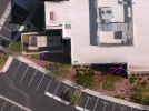
300-acre map using RS2 as ground Base
No CPs or GCPs as it was almost impossible due to a major highway crossing middle ground and so much housing development etc...
Can not show full features but can show reports from PIX and DD.
325ft AGL, .95 GSD, 12 MPH, 75 front, 65 side overlap
Lost fix to float for about 20 photos...
Thoughts please? always find it hard to read PIX as I am so used to DD
The client seemed very happy, a BIM and GIS company
They wanted the deliverable in.ECW format not sure what that is, so I sent the GeoTIFF ortho and DTM
all comments are welcome, and what is an ECW file type?


")


