Hi- still mulling potential purchase of of the Evo II E.
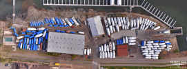
Would anyone be able to share some sample nadir images, ideally from a variety of altitudes (100ft, 200ft, 300ft, 400ft)?
There was one thread here previously that had a few, but the files are no longer shared.
Thanks much!
Would anyone be able to share some sample nadir images, ideally from a variety of altitudes (100ft, 200ft, 300ft, 400ft)?
There was one thread here previously that had a few, but the files are no longer shared.
Thanks much!