Welcome, Autel Pilots!
Join our free Autel drone community today!
Join Us

Autel Evo 2 Pro V2 PIX4d

Bunderwood1

New Member
Joined
May 3, 2022
Messages
1
Reaction score
1
Age
37
I am new to the Autel world but have heard a lot of good things. I am trying to make 2d ortho images of job sites. The last job site that I flew I had 8 Ground Control points set with Survey Grade equipment. This is a 10 acre site, and after I process everything the image looks great. Except its not matching up with the Ground Control that I have gone in and calibrated to. I was just wondering if anyone has had success using GCP's and getting the image to be fairly tight on the GCPS.
 
  • Like
Reactions: edgardcafe
I am new to the Autel world but have heard a lot of good things. I am trying to make 2d ortho images of job sites. The last job site that I flew I had 8 Ground Control points set with Survey Grade equipment. This is a 10 acre site, and after I process everything the image looks great. Except its not matching up with the Ground Control that I have gone in and calibrated to. I was just wondering if anyone has had success using GCP's and getting the image to be fairly tight on the GCPS.
I'm in the same boat. I've flown several test flights with GCP's and haven't been able to get close on any of them. I use a Emlid RS2+ for my base set on a known point and send correction to the drone/controller via elmid's caster service. The workflow has been working perfectly with my M300, everything with the EVO 2 connects fine get a fix but when I process it in Pix4D mapper horizontal and vertical are all over the place. Pix4d support wasn't much help and haven't heard from Autel support yet. The folks on the Emlid forum have been very helpful. I posted on this forum as well and jmason702 replied with this "On your mapping mission settings it has PIX4D setting, did you have that on?" I haven't found that setting yet.
This shouldn't be this difficult to get this drone working with Pix4d.
 
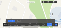
Regarding the Pix4D setting, if you scroll right on the bottom of your screen when you are constructing a mapping mission you see the option to select Pix4D. Hope this helps.
 
Regarding the Pix4D setting, if you scroll right on the bottom of your screen when you are constructing a mapping mission you see the option to select Pix4D. Hope this helps.
Yeah, jmason702 was saying the same thing. I'm running version 3.0.21 and it doesn't look like it's in there.
 

Latest threads

Members online

No members online now.

Forum statistics

Threads
11,281
Messages
102,959
Members
9,880
Latest member
chuckster58