AWESOMEGuess what showed up at the doorstep finally?
I won't have time to start flight tests until mid/end of next week. I have an RTK module coming mid week so I'll probably wait until that shows up for testing anyway.


You are using an out of date browser. It may not display this or other websites correctly.
You should upgrade or use an alternative browser.
You should upgrade or use an alternative browser.
640T and MAPPING
- Thread starter jmason702
- Start date


vr-pilot
Well-Known Member
- Joined
- Nov 11, 2021
- Messages
- 76
- Reaction score
- 50
- Age
- 56
Congratulations! That is great!Guess what showed up at the doorstep finally?
I won't have time to start flight tests until mid/end of next week. I have an RTK module coming mid week so I'll probably wait until that shows up for testing anyway.
I got a time vs. weather problem here. Although the unit came on the 20th I only had time and decent enough weather on the 23rd and 28th for less than 3 hours each. At least I got my eight batteries lined up and logged in DroneLogbook. Their integreation hub uses the Autel flight database and via the Cloud-Sync Integration I can import all my log-files. Battery management (serial numbers, flight cycles) is also integrated, 2D/3D map view replays, weather data etc. (and all that without any SD-card or USB connection hassle)
I would suggest that you could measwhile get to know quite some of that awesome UAS' functionalities before you start putting on the RTK module. (O.K., I did so too in the middle of the night (on ground!) just to see if the RTK loggin works and how good the values are, and they were great!)
The drone being small and lightwight made me think to get everything understood very fast, but the complexity that comes with the dual cams and their integration within the Explorer App for manual and mission flights is really huge.
Yesterday I wanted to do a first RTK-mission: on the last landing before that mission I got a warning for the left obstacle sensor and that I should calibrate it. Because I was so excited about the upcoming RTK mission and the "RTK-FIX" and "Safe to fly" all-green-messages I "disregarded" the sensor warning and took off. Some seconds later in the air at 35 m AGL and still in manual conrtol (RTK mission at 45 m not yet started) the bird began to behave quite eratically. I did not start the mission, deactivated RTK and Obstacle Avoidance and landed in my hand (what I do have to practice). So until now I don't know if RTK-floats, "disregarding" obstacle sensor calibration warnings (or a combination of both) caused this behaviour. Last night I calibarted the left sensor...
I nevertheless flew that mission without RTK module and OAS deactivated without any issues and very good flight performance.
In all I got 3 h 05 m flight time and the brid itself and the apps are great! One more example: I tried the oblique mission mode and interrupted it 3 times intentionally for battery changes (I fly new batteries down to 50% on the first and to 25% on the second mission). The oblique mission consists of a nadir part and four oblique parts and mission parameters can be set for both kinds individually. And although that mission was interrupted three times it did not miss one single picture or had any doublettes... The camera line up in DD was 100 % perfect for nadir and oblique.
Right now we have rain again and wind gusts of 40 kt (TAF going up to 50 kt), so it is one of these days where you better don't find yourself wishing to be on the ground. Although the EVO2 Enterprise claims wind resistance of 17 to 20 m/s (grade 8 beaufort scale, 34 - 40 kt), so it would still be fine considering the gusts ;-) No, just kidding and especially not with a new unit. One has to gradually find the own limits within the individual gained confidence, nevertheless within official limits.
Last edited:
vr-pilot
Well-Known Member
- Joined
- Nov 11, 2021
- Messages
- 76
- Reaction score
- 50
- Age
- 56
Little update on my "floating experience" during the first RTK-flight (it was not due to the left obstacle sensor that wanted a calibration):So until now I don't know if RTK-floats, "disregarding" obstacle sensor calibration warnings (or a combination of both) caused this behaviour. Last night I calibarted the left sensor...
Today I managed - during the second try - a very successful RTK-flight. (DD: X 0.02m Y 0.04m Z 0.02m RMSE 0.03m)
I noticed that on the first try I used a RTCM 3.2 NTRIP mount point connection offered by my provider. It contains the "newer" MSM4 RTCM3 messages for GPS (1074), GLONASS (1084), Galileo (1094) and BeiDou (1124) which I thought would be a good choice because these four GNSS systems are mentioned on the Smart Controller's RTK page and their sat counts are monitored.
But after getting (finally) a FIX on ground and being able to take-off the RTK FIX got lost and I had to switch off RTK on its settings page due to "floating and re-positioning" effects.
So today I tried the RTCM 3.1 NTRIP mount point connection that sends the "more legacy" RTCM3 messages. It only uses GPS (1004) and GLONASS (1012).
These two come along with the ARP message 1006 (antenna refernce point), message 1008 (Antenna descriptor and Serial Number) and 1033 (Receiver and antenna descriptors).
(Further messages 1021, 1023,1025, 1029, 1030, 1031, 1032)
Nevertheless the "RTK FIX" sat count icon on the Smart Controller (V2, Enterprise RTK) showed all four GNSSs (GPS, GLO, GAL, BDS) summed up (max. 37 sats IIRC).
In the end precision counts and being measured by DD at X=2 cm , Y=4 cm, Z=2 cm is a very good start at 5 m/s ;-) (on the second try)
RINEX observation and Timestamp files both were "nicely populated".
Afterwards I flew a mission with the RTK's page switch set to off (using Network "NONE" does not allow me to start motors because of a red "not safe to fly" message) and also here the L1+L2 from the RTK module with RINEX observation and Timestamp files both were written with according data amounts.
So "in a nutshell" or "long story short": for me the RTK module works stable and precise with RTCM 3.1 mounting point messages only. I could not find it documented.
Last edited:
vr-pilot
Well-Known Member
- Joined
- Nov 11, 2021
- Messages
- 76
- Reaction score
- 50
- Age
- 56
Just out of curiosity:when using my base I get a fix in less than 5 seconds
when you chose your base station there is no "A-RTK" selection on the Remote Controller's RTK settings screen, right?
You just chose "Custom Network", and then enter the NTRIP IP, Port, User and Password when connected via WLAN with your base station? And what about the last item "Mounting Point"? Does your base station settings provide a name for this?
I am asking because of thinking about using an A-RTK/Base Station (i.e. over a known geo location) in case of poor network availability. There are threads in cummunities (i.e. Emlid) that A-RTK only works with base stations that come from the drone manufacturers themselves (i.e. Yuneec and DJI). But at least for Autel this seems not to be true. One example here of my dealer from Italy:
Here they use a "South G7" base station successfully with an EVO2 RTK (not Enterprise as it seems) which they fly at the beginning of the video (with the Standard Remote Controller) and which is also depicted on the graphic at 3m05s. The video is labled "EVO2 RTK Enterprise NTRIP Host mode con South G7" though.
From 1m36s on and in the description below the video (in Italian, well worth reading/translating) they explicitly say that the successful RTK/PPK test also applies to the Enterprise with RTK module.
(I am always a bit sceptical if really all the functionalities of the "more dedicated" EVO2 RTK model also apply 1:1 to the EVO2 Enterprise with the RTK module. This scepticism derives from the M2EA that uses RTK only for positioning, not for imagery RTK/PPK).
You just chose "Custom Network", and then enter the NTRIP IP, Port, User and Password when connected via WLAN with your base station? (YES)Just out of curiosity:
when you chose your base station there is no "A-RTK" selection on the Remote Controller's RTK settings screen, right?
You just chose "Custom Network", and then enter the NTRIP IP, Port, User and Password when connected via WLAN with your base station? And what about the last item "Mounting Point"? Does your base station settings provide a name for this?
I am asking because of thinking about using an A-RTK/Base Station (i.e. over a known geo location) in case of poor network availability. There are threads in cummunities (i.e. Emlid) that A-RTK only works with base stations that come from the drone manufacturers themselves (i.e. Yuneec and DJI). But at least for Autel this seems not to be true. One example here of my dealer from Italy:
Here they use a "South G7" base station successfully with an EVO2 RTK (not Enterprise as it seems) which they fly at the beginning of the video (with the Standard Remote Controller) and which is also depicted on the graphic at 3m05s. The video is labled "EVO2 RTK Enterprise NTRIP Host mode con South G7" though.
From 1m36s on and in the description below the video (in Italian, well worth reading/translating) they explicitly say that the successful RTK/PPK test also applies to the Enterprise with RTK module.
(I am always a bit sceptical if really all the functionalities of the "more dedicated" EVO2 RTK model also apply 1:1 to the EVO2 Enterprise with the RTK module. This scepticism derives from the M2EA that uses RTK only for positioning, not for imagery RTK/PPK).
I use Emlids Caster to send corrections to the drone, just look up emlid caster, I really love this method of mapping
This method works great with EVO RTK, from what I have seen on here it seems the EVO RTK has fewer problems than the enterprise.
I have never had any issues with my RTK, The RTK uses a different firmware than the enterprise.
Emlid RS2 is GREAT, I did not know the A-RTK was available yet.
Emlid Caster gives you a mount point for the drone to connect to.
Last edited:
You set up Ntrip in from localhost, and Ntrip out to the drone, if that makes senseI use Emlids Caster to send corrections to the drone, just look up emlid caster, I really love this method of mapping
This method works great with EVO RTK, from what I have seen on here it seems the EVO RTK has fewer problems than the enterprise.
I have never had any issues with my RTK, The RTK uses a different firmware than the enterprise.
Emlid RS2 is GREAT, I did not know the A-RTK was available yet.
Emlid Caster gives you a mount point for the drone to connect to.
Attachments

Dave Pitman
Well-Known Member
Emlid caster actually works over the internet, just want to clarify that. But users have requested that the RS2 be able to act indipendantly as a caster and send corrections directly over a WLAN in order to use where internet is not available and Emlid is considering it.You just chose "Custom Network", and then enter the NTRIP IP, Port, User and Password when connected via WLAN with your base station? (YES)
Otherwise, carry on!
Last edited:
Dave Pitman
Well-Known Member
Update: The RS2 can now generate it's own WLAN and NTRIP caster without internet connectivity.users have requested that the RS2 be able to act indipendantly as a caster and send corrections directly over a WLAN in order to use where internet is not available and Emlid is considering it.
What's New
• We added the ability to edit the name and description of existing survey projects.
• ReachView 3 now supports DXF export with the point name and height as text objects.
• The collector tool now makes a sound upon successful point collection.
• Added a new option for the Correction output—“Local NTRIP.”
• Various fixes and improvements.
Last edited:
vr-pilot
Well-Known Member
- Joined
- Nov 11, 2021
- Messages
- 76
- Reaction score
- 50
- Age
- 56
That sounds great.Update: The RS2 can now generate it's own WLAN and NTRIP caster without internet connectivity.
So just for my understanding: in case of no internet connectivity using such a local WLAN from the RS2 to cast NTRIP data would require
a) positioning the RS2 as the base station antenna over a known geo location and enter these XYZ table values as its local reference fix (thus calculating phase corrections to be casted), or
b) when positioning the RS2 over an unkonwn geo location allowing the base sation to pre-collect phase shift GNSS data from 1 to 3 hours in advance in order to cast sufficiently precise/stable correction data to the rover for real time applications (suchs as handheld rover's point collection or drone's positioning and imagery geo tagging).
Would that be correct?
Dave Pitman
Well-Known Member
CorrectSo just for my understanding: in case of no internet connectivity using such a local WLAN from the RS2 to cast NTRIP data would require
a) positioning the RS2 as the base station antenna over a known geo location and enter these XYZ table values as its local reference fix (thus calculating phase corrections to be casted),
b) when positioning the RS2 over an unkonwn geo location allowing the base sation to pre-collect phase shift GNSS data from 1 to 3 hours in advance in order to cast sufficiently precise/stable correction data to the rover for real time applications (suchs as handheld rover's point collection or drone's positioning and imagery geo tagging).
Yes. I have not done this personally, so with that caveat stated...
In this case, if you had the time, it would be best if you collect and average on the RS2 for as long as practically possible, and back at the office use a PPK workflow on the base point if there is an available CORS network within a practical distance, or a PPP workflow if not. This would then give you a "know point" to use going forward with an RTK workflow casting corrections from the RS2 to your rover/drone just like the a above.
I am unsure if you could average with the RS2 and simultaneously cast corrections to rovers and then tighten everything up back at the office using either PPK or PPP workflows. But it's possible.
Alternatively, if you could occupy a point with the RS2 for a good period of time, like 1-3 hours with good metrics, sky view, DoP, etc., and then in the same session, use that point to then cast RTK corrections to the rover, that would logically give you much greater precision for your project than just using single solution coordinates on the rover, if that makes sense.
Dave Pitman
Well-Known Member
Re-reading your comment, I wanted to be clear that the the Local NTRIP over a local WLAN won't broadcast far enough for a typical rover. It is designed for working with drones where corrections are transmitted to the drone via the controller and not the RS2 directly.in order to cast sufficiently precise/stable correction data to the rover for real time applications (suchs as handheld rover's point collection or drone's positioning and imagery geo tagging).

Dave Pitman
Well-Known Member
I see you are on the Emlid forum. If Dirk is correct about port #s then Emlid will probably make something happen. If we have to wait for Autel to do something, well... probably won't happen.
Probably is an issue of the ports but if you enter an incorrect IP o Port number the message is other, something like "check the RTK settings". I have tested other GNSS brand (Comnav T300 Plus) with Local NTRIP where the port is 80, in the Autel Explorer the value I have had to enter is 0080, then it works perfect.I see you are on the Emlid forum. If Dirk is correct about port #s then Emlid will probably make something happen. If we have to wait for Autel to do something, well... probably won't happen.
your NTRIP HOST is wrongI have tried to use the local Ntrip from RS2 with an EVO II Pro RTK with the standard controller but I received this message.
View attachment 13118
I believe it is not a problem of the RS2 because in the Lefebure NTRIP Client app I can receive corrections with no problem.
should be emlidcaster.com I belive
Dave Pitman
Well-Known Member
your NTRIP HOST is wrong
should be emlidcaster.com I belive
This is with the new local caster that was just released. Reachveiw tells you the parameters to use.
Attachments
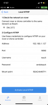
10-4This is with the new local caster that was just released. Reachveiw tells you the parameters to use.
Wow, this is exciting news!!!Update: The RS2 can now generate it's own WLAN and NTRIP caster without internet connectivity.
Unfortunately I went to the dark side on this and got the Phantom 4 RTK as I don't have time for Autel to fix the problems with the Evo 2 Enterprise and I have major mapping projects waiting for warmer weather.
This new feature should work with the P4RTK correct? As the P4RTK's GCS controller is what is receiving the corrections and then broadcasting to the drone?
Similar threads
- Replies
- 0
- Views
- 664
- Replies
- 0
- Views
- 2K
- Replies
- 0
- Views
- 705
- Replies
- 0
- Views
- 2K


Latest threads
-
-
-
Seeking Recommendations for Custom Voiceover Solutions
- Started by nobes
- Replies: 1
-
We need your Autel evo 2 V1 6K rugged bundle.
- Started by Autel-euducational
- Replies: 1
-
Questions on original Evo 1 and the new app Autel Sky
- Started by jaja6009
- Replies: 0